
Wildfire risk reduction and restoration projects
Kootenay National Park
Parks Canada’s fire management program is working to make the landscape in Kootenay National Park healthier and more resilient. This program includes projects that lower the risk of wildfires to people and infrastructure and help bring back healthy ecosystems.
In Kootenay National Park, a resilient landscape has a good mix of different ages forests. These areas have better ability to stay healthy as the climate changes and wildfire activity increases.
To reduce wildfire risk and restore these areas, we use methods such as prescribed fire, FireSmart™, hand thinning, and mechanical tree removal.
Prescribed fires
In Kootenay National Park, prescribed fire season is generally April to June, and mid-August to October.
A prescribed fire is a well-planned fire that is purposely lit by well-trained fire specialists. Each prescribed fire has clear goals and can only be lit when specific conditions from the prescribed fire plan are met. Conditions include things like weather and the state of the environment. Because of this, it may take several years before the right conditions happen, and the fire can be safely lit.
2026 prescribed fire details
Updates will be available here when a prescribed fire is underway.
Approved prescribed fire plans
Kootenay Crossing Meadow
Time of year: Spring/fall
Size: 22 hectares
Location: Near Kootenay Crossing Operations Centre, in central Kootenay National Park. 45 km north of the Village of Radium Hot Spring on highway 93 South.
Additional details: The Kootenay Crossing Meadow prescribed fire is part of a larger meadows restoration plan.
The prescribed fire will help to:
- help restore the natural fire cycle, which normally includes low to moderate‑severity wildfires
- reduce trees growing in the meadow to restore a healthy meadow ecosystem
- support the re‑growth of native grasses and shrubs
- lower the risk of severe wildfires and help the landscape become more resilient to future fires

Map of Kootenay Crossing Meadow prescribed fire treatment area — Text version
This map shows the Kootenay Crossing Meadow prescribed fire area in Kootenay National Park. The main map shows a satellite-style view. It has the treatment area shown in orange near the centre of the image. The treatment area is located beside Highway 93 South and close to the Kootenay Crossing Parks Canada Operations Centre. This map shows the surrounding landscape which includes forested valleys, and nearby river channels.
In the top-left corner, an inset map shows where the project is located within the larger region of Kootenay National Park. A key reference point is the Village of Radium Hot Springs at the bottom of the inset map. A 0 to 1.5 km scale bar and north arrow are directly below the inset map. The map is labeled “Kootenay Crossing Meadow prescribed fire” and includes an icon legend identifying the treatment area.
McLeod Meadows
Time of year: Spring/fall
Size: 1.8 hectares
Location: Near McLeod Meadows Campground, in the southern end of Kootenay National Park. 35 km north of the Village of Radium Hot Springs on Highway 93 South.
Additional details: The McLeod Meadows prescribed fire is part of a larger meadows restoration plan.
The prescribed fire will help to:
- help restore the natural fire cycle, which normally includes low to moderate‑severity wildfires
- reduce trees growing in the meadow to restore a healthy meadow ecosystem
- support the re‑growth of native grasses and shrubs
- lower the risk of severe wildfires and help the landscape become more resilient to future fires
- maintain the area used for the McLeod Meadows fire weather station

Map of McLeod Meadows prescribed fire treatment area — Text version
This map shows the McLeod Meadows prescribed fire area in Kootenay National Park. The main map shows a satellite-style view. It has the treatment area shown in orange near the centre of the image. The treatment area is located on the west side of Highway 93 South, close to the road. It is also close to McLeod Meadows Campground and Dog Lake Trailhead which are shown on the east side of Highway 93 South. This map shows the surrounding landscape which primarily includes a forested valley and the Kootenay River.
In the top-left corner, an inset map shows where the project is located within the larger region of Kootenay National Park. A 0 to 0.5 km scale bar and north arrow are directly below the inset map. The map is labeled “McLeod Meadows prescribed fire” and includes an icon legend identifying the treatment area.
Redstreak Ecosystem Restoration Project
Time of year: Spring/fall
Size: 437 hectares
Location: Along the southern boundary of Kootenay National Park. Approximately 50 to 500 m from the Village of Radium Hot Springs.
Additional details: The Redstreak Ecosystem Restoration Project area is made up of two units – the Bench Unit and the Mountain Unit. The Bench Unit is made up of several smaller areas called sub-units:
- North Guard – 8.6 ha
- Lower Guard – 36.2 ha
- Main Bench Unit –81.7 ha
- Lower Bench Unit – 53.7 ha
- Campground Unit – 19.2 ha
The Mountain Unit is 231.20 ha and includes a 2.51 ha fireguard that will be burned separately to the main Mountain Unit.
Prescribed fire operations may target a single unit or smaller sub‑units rather than the whole project area at once. Each prescribed fire contributes to the project’s goals by:
- reducing forest fuels near the Village of Radium Hot Springs to lower wildfire risk
- restoring open grassland and Douglas-fir forest ecosystems that support wildlife such as bighorn sheep, badgers, and nighthawks.
Open meadows and grasslands require low to moderate intensity fire on a regular basis. To take care of the Bench Unit, Parks Canada aims to use prescribed fire every 10 to 20 years. Learn more about previous prescribed fire in the Redstreak restoration area.
Vermilion Guard
Time of year: Spring/fall
Size: 75 hectares
Location: Northern end of Kootenay National Park. 2.4 Km west of the Kootenay – Banff National Park boundary and 3.8 Km east of Marble Canyon Campground.
Additional details: Two large wildfires have burned through Vermilion Pass in the last 60 years. During the 2003 Tokumm-Verendrye Wildfire, the Vermilion Guard was established to stop the wildfire from entering Banff National Park. Parks Canada plans to maintain the guard using prescribed fire to keep the strategic fuel break between Kootenay and Banff national parks.
The prescribed fire will help to:
- create a long-term fire break that helps protect communities in the Bow Valley from wildfires
- improve habitat for species at risk like grizzly bears and whitebark pine

Map of Vermilion Guard prescribed fire treatment area — Text version
This map shows the Vermilion Guard prescribed fire area in Kootenay National Park. The main map shows a satellite-style view. It has the treatment area shown in orange near the centre of the image. It is just east of the Stanley Glacier Trailhead along Highway 93 South. In the upper right portion (northeast of the prescribed fire area), the map borders Banff National Park, with the Continental Divide Day-use Area identified near the boundary. In the lower left portion (southwest of the prescribed fire area) the map shows Marble Canyon Campground and the Paint Pots Day-use Area.
In the top-left corner, an inset map shows where the project is located within the larger region of Kootenay National Park. A 0 to 3 km scale bar and north arrow are directly below the inset map. The map is labeled “Vermilion Guard prescribed fire” and includes an icon legend identifying the treatment area. The bottom of the map has the Government of Canada black bar with the Parks Canada and Government of Canada identifiers.
Prescribed fire plans in development
Prescribed fire planning is a complex process. Each prescribed fire plan can take years to complete. Once the prescribed fire plan is approved, the fire can be carried out in the same year if the weather and on site conditions are right.
Mitchell Ridge II
Time of year: Spring/fall
Size: 4,500 hectares
Location: South end of Kootenay National Park on the east side of the Kootenay River Valley near Settler’s Road. Approximately 5 km south of McLeod Meadows Campground, 3km east of the Kootenay Valley viewpoint and 16.5km east of the Village of Radium Hot Springs.
Additional details: In 2008 Parks Canada successfully burned 1,800 ha during the Mitchell Ridge prescribed fire. In 2023, a 307-ha wildfire burned the southern end of the same area. The Mitchell Ridge II prescribed fire will build off the previous prescribed fire and wildfire to improve ecosystem health and reduce woody debris that will lower future wildfire risk by restoring open forest–grassland conditions.
The Mitchell Ridge II prescribed fire includes three smaller areas called sub‑units. Fire specialists will focus on Unit B, which is 1,408 hectares in size.
The prescribed fire will help to:
- create a fuel break across the valley to lower the risk of a large wildfire in the southern end of Kootenay National Park
- imitate the natural fires that once happened regularly in this area, helping keep the forest’s plants varied, healthy, and of different ages
- improve habitat for Rocky Mountain bighorn sheep and for species at risk, such as grizzly bears and whitebark pine

Map of Mitchell Ridge prescribed fire treatment area — Text version
This map shows the Mitchell Ridge prescribed fire area in Kootenay National Park. The main map shows a satellite-style view. It has the treatment area shown in orange near the upper right side of the image. It is just east of the Kootenay River day use area, and McLeod Meadows campground.
In the top-left corner, an inset map shows where the project is located within the larger region of Kootenay National Park. A 0 to 8 km scale bar and north arrow are directly below the inset map. The map is labeled “Mitchell Ridge Prescribed Fire” and includes an icon legend identifying the treatment area. The bottom of the map has the Government of Canada black bar with the Parks Canada and Government of Canada identifiers.
Frequently asked questions
Why does Parks Canada conduct prescribed fires?
Parks Canada uses prescribed fire for two main reasons –to maintain and restore the health of ecosystems and to reduce the risk of wildfire. Parks Canada has also used prescribed fire to restore and maintain cultural landscapes and cultural resources such as archaeological sites. Prescribed fire is an important tool to remove excess vegetation that can fuel dangerous wildfires, recycle nutrients into the soil, and create habitats for plants and wildlife that depend on fire.
What goes into assessing where, when and how a prescribed fire is implemented?
Prescribed fires are complex operations that may need several years of preparation. Before a prescribed fire is set, a detailed plan – also called a prescription – is developed. It outlines very specific conditions in which the prescribed fire must meet, before being implemented. Conditions include:
- outlining the goals of the prescribed fire. Parks Canada conducts prescribed fires for two main reasons – improve the health of ecosystems and reduce the risk of wildfire
- identifying the local weather and environmental conditions, including wind direction and speed needed during the prescribed fire
- identifying mitigations to reduce impacts on the environment and on cultural sites
- determining the resources, for example personnel and equipment, needed to complete the work
Each prescribed fire plan is peer-reviewed and requires an environmental impact assessment
Does each prescribed fire have its own plan?
Every prescribed fire requires its own detailed plan because each prescribed fire is different. Differences include the shape and size, the objectives, the fuels present, the environmental conditions and desired fire intensity. Some prescribed fires are designed to be low intensity and low complexity, such as burning grass in backcountry meadows. These fires usually make less smoke and can be finished in a day or two. Other prescribed fires are higher intensity and aim to burn most of the mature trees (stand replacing fire). These are used in areas where fire has been absent for a long time, and forest conditions are no longer following their natural cycle. These fires reduce dense, flammable trees and help a healthier, more resilient forest grow back. Although they require more planning, they also create fuel breaks in steep or remote areas where mechanical tree removal is impossible.
How is prescribed fire work carried out?
After the prescribed fire plan is approved, fire specialists wait for the right “burn window.” This very specific window appears when all the conditions in the fire plan are met.
Before lighting the prescribed fire, the National Fire Duty Officer, Field Unit Superintendent and the Incident Commander give final approval. They use a checklist to confirm that all conditions identified in the plan are met and ensure resources are in place for safety.
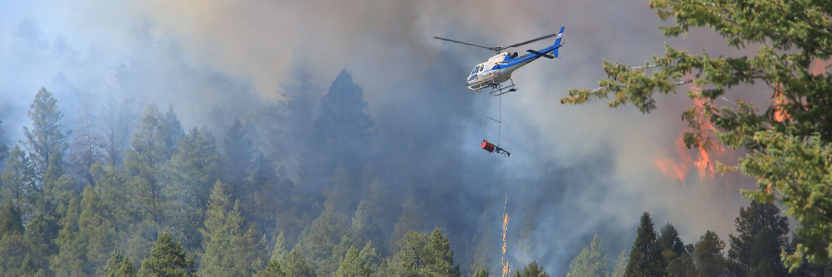
Depending on the plan, fire specialists may light the fire from the ground with drip torches, from the air with helicopters, or both. During operations, people can expect to see flames, smoke, equipment like sprinklers and hoses, and fire crews working in the area. Helicopters bucketing water may also take place. These are all part of normal prescribed fire operations.
Several tools are used to ensure a fire stays within its planned boundaries including:
- natural features such as lakes, rivers and avalanche paths
- man-made control lines such as fuel treatments and sprinkler systems
- ground crews and helicopters
Right after a prescribed fire, crews monitor the area closely. Fire crews action hotspots near the boundary of the prescribed fire area. Long-term checks continue for years to see if the goals of the burn are met. These goals can include creating wildlife habitat, restoring plant species, and protecting communities.
Why are prescribed fires lit when it’s hot out?
Lighting a prescribed fire when it’s hot out might seem counterintuitive, but there are strategic reasons for doing it under those conditions. Here’s why:
- Fuel moisture is low: Hot weather usually means dry vegetation, which burns more predictably and allows a cleaner burn to identified control lines, reducing the chance of escape. Prescribed fires located at higher elevations and/or in a confined valley may require higher than normal conditions, like temperature and dryness, to meet objectives. This is because fuels can be wetter than in the valley bottom and in areas sheltered by the wind. However, some environments, like meadows, have fuels that dry out quickly. This means that they require less hot and dry conditions to successfully burn and can burn in less hot periods – like the early spring or late fall. Fire specialists want fuels to be dry enough to ignite easily but not so dry that the fire is uncontrollable.
- Desirable fire behavior: In hot conditions, fire behavior can be more consistent and easier to regulate especially if humidity and wind are also within acceptable ranges. This helps crews manage the prescribed fire more safely.
- Meeting ecological objectives: Some ecosystems (like certain forest types) require hotter fires to stimulate native plant growth or clear out trees and vegetation. Historically, these areas naturally burned during periods of dry weather. Prescribed fires are now carefully planned and carried out during similar dry conditions to help copy natural fire patterns. Burning under these conditions allows fire to do its work on the land while still being safely managed.
- Wind and atmospheric stability: Hot days often come with unstable atmospheric conditions, which can help smoke rise and disperse rather than linger near the ground—important for air quality and visibility.
It’s all about balance – prescribed fires are only lit when very specific criteria (called a prescribed fire plan) are met. These include:
- temperature
- humidity
- wind speed and direction
- fuel moisture
- crew availability and safety resources
- desired time of year
How do prescribed fires affect residents and visitors in the national park?
Prescribed fires are planned to minimize impacts on people, but they can still affect residents and visitors inside and outside of the national park.
Parks Canada fire specialists make every effort to limit smoke during prescribed fire operations. Prescribed fires only go ahead if conditions allow smoke to disperse into the atmosphere. However, unpredicted changes in weather can increase and redirect smoke. Smoke can reduce visibility on sections of highways which can potentially cause delays.
Safety is always the top priority for Parks Canada in all fire management operations. During a prescribed fire, area closures are often in place until the area is deemed safe to enter.
While smoke may temporarily reduce air quality or visibility, and some areas may have restricted access, these effects are short-term and carefully managed. In the long run, prescribed fires help protect communities by reducing the risk of severe wildfires and improving forest health.
Why are you creating/adding to smoky conditions?
While prescribed fires may cause temporary smoke, they play a vital role in reducing the risk of severe wildfires — which can blanket communities in smoke for weeks or even months. Parks Canada uses prescribed fires and managed wildfire to reduce the likelihood and intensity of wildfires by reducing fuels during desirable conditions.
Fire protection and restoration projects in nearby national parks:
Wildfire risk reduction and FireSmart™ projects
Any community that borders a vegetated or forested landscape can be impacted by wildfire. Parks Canada’s fire management efforts help lessen this risk.
In addition to prescribed fire and managed wildfires, fire personnel use a variety of other wildfire risk reduction strategies. These include:

Did you know: Parks Canada is an active member of the FireSmart™ program. The FireSmart™ program empowers the public and increases community resilience to wildfire across Canada.
Learn more about how you can protect yourself and your community.
Visit FireSmart Canada to learn what you can do to FireSmart™ your home and community.
- FireSmart™
- forest thinning
- mechanical tree removal
Each of these strategies reduces the amount of fuel (trees) in the area. This helps protect the public, communities, and infrastructure by:
- limiting fire intensity
- reducing the potential for spot fires from windblown embers
- improving the effectiveness of fire suppression techniques
Approved wildfire risk reduction and FireSmart™ projects
Dry Gulch open Douglas fir forest restoration and wildfire risk reduction (seasonal, ongoing)
Annually, between October and March, Parks Canada will selectively remove/limb vegetation (branches, logs, shrubs, trees) in the Dry Gulch area of southwestern Kootenay National Park.
This is part of a multi-year project to reduce Douglas fir forest encroachment on approximately 800 hectares of grassland ecosystems.
The thinning of dense vegetation helps to reduce wildfire risk and supports habitat restoration for a variety of wildlife species, including Rocky Mountain bighorn sheep. This project contributes to the larger grassland restoration efforts that have been conducted in southern Kootenay National Park such as Sinclair Canyon and Redstreak.
During operations:
- There are no anticipated impacts to visitors or residents.
- All tree falling will be conducted by hand.
- Woody debris will be piled and burned on site. Smoke may be visible along Highway 93-95 near Dry Gulch Provincial Park.
Redstreak Campground wildfire risk reduction (seasonal, ongoing)
During Redstreak Campground’s seasonal closure, Parks Canada will work on thinning and limbing vegetation within forested areas as well as removing Douglas fir regeneration.
Thinning and regular maintenance (removing regrowth) are important to keep areas open, reducing the risk of wildfire. Work at Redstreak Campground will help reduce wildfire risk to campers, staff and the Village of Radium Hot Springs.
Work areas will be closed. These closure details will be posted on site. For visitor and staff safety, please respect all closures and warning signs.
Woody debris will be piled and burned onsite. Smoke may be visible coming from Redstreak Campground.
Kootenay Crossing Meadow wildfire risk reduction work (seasonal, ongoing)
Annually, between October and March, work will focus on reducing the number of trees within Kootenay Crossing Meadow. This work will improve conditions for future meadow prescribed fire operations in this area.
Woody debris will be piled and burned onsite. Smoke may be visible along Highway 93 South in the Kootenay Crossing area.
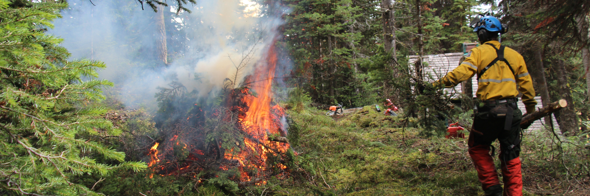
Pile Burning (seasonal, ongoing)
During wildfire risk reduction work, trees, tree limbs, and brush are put into piles. Sometimes these piles of woody debris are too wet, or venting conditions are too poor to burn. These piles are left, and crews return to burn when the piles are dry, and conditions are good.
The piles of woody debris are in different locations around Kootenay National Park.
Burning at each location will only take place when safe to do so and when appropriate venting conditions exist. Visitors and residents can expect to see smoke. Treatment areas will be closed when crews are burning the piles of woody debris. The work will not affect trails, roads, or facilities. Closure details will be posted on site. Please respect all closures and warning signs.
Learn more about Parks Canada's efforts in reducing the risk of wildfires across the country.
Email notification lists
Stay informed about fire management activities by joining the Fire information email list.
When you subscribe, you’ll receive updates on:
- Wildfire activity and incidents
- Prescribed burns
- Wildfire risk reduction projects
- Fire bans and restrictions
- Smoke advisories and air quality impacts
- Date modified :