
Bulletins
Rouge National Urban Park
Partial closure of Northeast Trail for invasive species management
Issued: June 22, 2026
Ends: June 25, 2026
Starting Tuesday, June 23, the Toronto and Region Conservation Authority will conduct invasive species management targeting reed canary grass near Black Walnut Day Use Area as well as in a restored habitat near Ninth Line and Donald Cousens Parkway.
A section of Northeast Trail will be closed from Black Walnut Day Use Area to York Durham Line between Tuesday, June 23 and Thursday, June 25. Visitors may still access Northeast Trail east of York Durham Line from Concession Road 9, Sideline 30 and Glasgow Day Use Area trailheads.
Visitors are asked to respect all closures, signage and the direction of work crews in the vicinity. Please consider visiting other areas of the park while work is being carried out.
Reed canary grass is an aggressive invasive plant species that poses a substantial threat to native wetland plants and wildlife. Toronto and Region Conservation Authority contractors will apply herbicide as an action to reduce its abundance and provide opportunity for native wetland tree and shrub restoration plantings to establish and naturally out-compete the grass as they grow.
Application is conducted in accordance with Health Canada guidelines and by trained and licensed contractors. Signage is posted 24 hours in advance of herbicide use in restoration sites and is removed 48 hours after the treatment is complete.
Planned invasive species management is integral to restoring healthy ecosystems in Rouge National Urban Park and increasing habitat for species at risk and other wildlife. The effectiveness of management actions is monitored seasonally to determine future actions. By managing invasive species, Parks Canada is working to improve ecosystems and achieve restoration goals in Rouge National Urban Park.
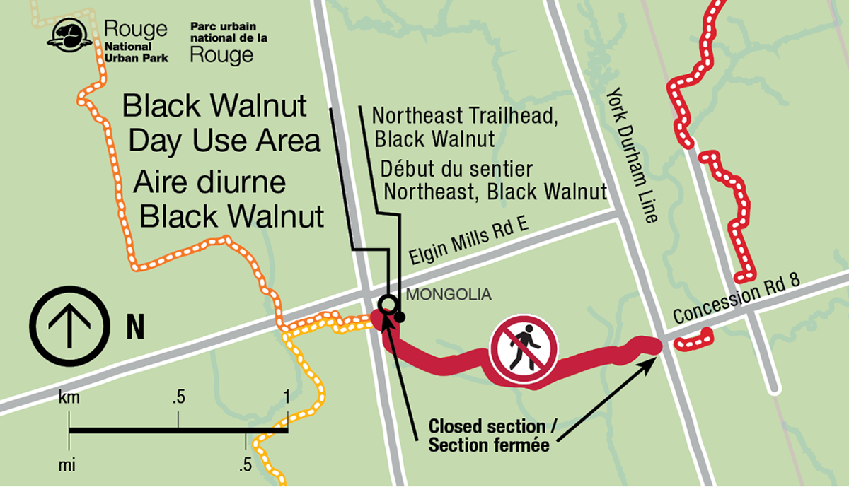
Text version
Map of a section of Rouge National Urban Park showing a trail closure near the Black Walnut Day Use Area.
The map is oriented north-up, with a north arrow on the left side and a scale bar showing distances in kilometres and miles. The Black Walnut Day Use Area is located in the upper-left portion of the map. A dotted orange trail runs through this area and connects to the trail network.
The Northeast Trailhead, Black Walnut is marked near the centre-left of the map, just north of Elgin Mills Road East. A trailhead symbol indicates the access point.
Roads shown include Elgin Mills Road East, running east–west across the centre of the map; York Durham Line, running north–south to the east of the trailhead; and Concession Road 8, intersecting York Durham Line farther east.
A thick red line highlights a closed section of trail extending eastward from the Northeast Trailhead area toward York Durham Line and Concession Road 8. A circular symbol showing a pedestrian crossed out indicates that this trail segment is closed to public access. Text beside the red line reads “Closed section / Section fermée.”
An arrow points from the closure notice toward the highlighted red trail segment, emphasizing the location of the closure. Additional trail segments appear east of York Durham Line, but the connection between the trailhead and those eastern segments is interrupted by the closure.
Key information: The trail connection east of the Northeast Trailhead at Black Walnut is closed, preventing through access between the trailhead area and trail sections east of York Durham Line.
- Date modified :