
Marmot Basin Ski Area Site Guidelines for Development and Use
Jasper National Park
Downhill skiing has a long history in Canada's mountains national parks. In the 1940's ski areas had rustic and basic facilities reflective of the emerging tourism industry of the parks at that time. Over the years, the ski areas have grown and updated their facilities, become internationally recognized and now attract over a million skiers. Winter visitors come to the mountain national parks each year to pursue the rewards of skiing with their families and friends within the backdrop of unparalleled mountain scenery, diverse ski terrain, reliable snow conditions and protected wilderness settings. The Marmot Basin Ski Area is located in Jasper National Park and was established in the late 1960's. The ski area has played an increasingly important role in tourism in the park over the last 40 years and now directly supports the economic well being of the community in winter. The park is an important international symbol of Canada and the national park system. It is part of the Canadian Rocky Mountain Parks World Heritage Site. Jasper, like all national parks, is dedicated to protecting and presenting a special part of Canada's natural and cultural heritage for the benefit, education and enjoyment of present and future generations. One of the biggest questions for national parks is how to clearly state and implement the direction national parks are taking in managing development, growth and use. At Marmot Basin, growth has been carefully controlled to ensure ecological integrity. However because of the evolving nature of the skiing industry and the close ties of the ski area to the well being of the tourism industry, there are demands for expanded services and facilities at the ski area to assist the ski area in remaining competitive. The role of these site guidelines is to guide change and ensure that Parks Canada's mandate is achieved for years to come. On December 8, 2006, the Minister of Environment announced refinements to Ski Area Management Guidelines to guide the ski area planning process for the mountain national park ski areas. The primary goal of the Guidelines is to provide land use certainty for the ski areas, the Canadian public and Parks Canada. The Ski Area Management Guidelines are based on a number of principles to guide the preparation of ski area Long-Range Plans. These Site Guidelines outline how this direction is to be achieved at Marmot Basin. The Marmot Basin Site Guidelines for Development and Use apply the principles as follows: 1. The approach taken to manage growth and the preparation of site guidelines and long-range plans at ski areas will be similar to that taken for communities and outlying commercial accommodation. The Marmot Basin Site Guidelines apply this principle by establishing permanent growth limits and ensuring that potential growth does not compromise the ecological health of the park. Ecological parameters have been established to ensure ecosystem functioning is maintained. Long-Range Plans, that are required to advance development, will need to demonstrate that the parameters will be achieved. The growth limits that have been negotiated with Marmot Basin include: the Developed Area (437 ha); the amount of ski terrain (275 ha); and the amount of commercial space (6,270 m2). Ski area development will be based on a design capacity of 6,500 skiers per day and balancing ski area resort components such as lifts, ski terrain, day lodges, parking and other services within terrain limitations to support a quality skiing experience while addressing ecological challenges. Growth will take place over time and issues surrounding infrastructure and staff housing will be addressed before related expansion takes place. In tandem with the growth limits established for communities and outlying commercial accommodation, the growth limits for Marmot Basin represent a significant long-term measure to ensure that the ecological integrity of the park is maintained. The potential development contemplated in these site guidelines will be advanced through the preparation of one or more Long-Range Plans and application of the Canadian Environmental Assessment Act (CEAA) and will need to be consistent with the Ski Area Management Guidelines and the Marmot Basin Site Guidelines for Development and Use. 2. Inside the Developed Area, new development can be considered where potential ecological impacts can be mitigated. The existing developed area represents the area that has been previously modified for skiing purposes. This includes ski runs, gladed areas, buildings, parking areas and other physical works. Within the existing developed area, the initiatives that Marmot may wish to pursue that can be considered if advanced as part of a formal Long-Range Plan proposal include: new lifts, lift upgrades and replacements; new runs and new gladed areas; run widening, terrain park development, expansion of snowmaking, expansion of parking within disturbed areas, mass transit, expansion of mid mountain and base area day lodges; terrain modification to address safety and environmental issues; and the consolidation and relocation of the maintenance buildings. A broad range of mitigation measures have been identified to ensure no significant impact to wildlife, vegetation and aquatic environments. Key ecological management parameters include: criteria for ski terrain design and vegetation management that reflect naturally occurring conditions; protection of sensitive and rare vegetation; protection of unique terrain features; preventing displacement of sensitive wildlife from important regional habitat; ensuring minimum flow requirements are maintained to support aquatic habitat; and maintaining water quality. 3. Outside the exiting Developed Area, new development can be considered if there is a Substantial Environmental Gain within or adjacent to the leasehold. Marmot Basin has proposed a substantial leasehold reconfiguration that would result in the removal of the Whistlers Creek bed area and surrounding up-slopes, to the extent shown on Map 1, from the ski area leasehold in exchange for consideration of potential initiatives that would be exceptions to the Ski Area Management Guidelines. The proposed lease reduction (approximately 18% overall) will provide greater certainty that Whistlers Creek bed and surrounding up-slopes will remain undeveloped. As such, it will provide greater long-term protection of ecological integrity in that portion of Whistlers Creek than would be the case if the area remained in the lease, including enhanced protection of valuable caribou habitat and enhanced protection of an important goat mineral lick. This improved level of long-term certainty and protection is considered a substantial environmental gain that will contribute meaningfully to Parks Canada's objective of maintaining or improving ecological integrity in Jasper National Park. In exchange for this voluntary lease reduction, Parks Canada is prepared to consider the following potential future initiatives as exceptions to the Ski Area Management Guidelines: expansion of the Developed Area; extension of the Knob Chairlift outside of the existing Developed Area; significant terrain modification for a realigned Knob Chairlift if alternatives prove impractical; development of a new beginner ski area and Nordic ski trails outside of the existing lease boundary; terrain modification to support the development of a terrain park and mid mountain reservoir; the development of a skier egress from the Tres Hombres off-piste area; and the development of a new ticket and group sales building in one of the parking lots. The ski area also wishes to pursue the development of ski lifts in the Tres Hombres and Outer Limits areas. Because the potential impact of development in these areas is not well understood, a decision on whether to potentially consider lifts in these areas will only be made upon completion of a caribou risk assessment. At a minimum, off-piste skiing can continue. 4. Ski areas will contribute to a unique, memorable national park experience and promote public appreciation and understanding of the heritage values of the park and world heritage site and local conservation initiatives. Improvements to lifts, day lodges, parking and additional ski terrain, if advanced as proposals, would all contribute to enhancing the skiing experience. To complement these efforts and reinforce the location of the ski area in a national park, Marmot Basin will carefully apply Best Management Practices for viewscapes, noise and external lighting and implement an architectural theme for building developments, renovations and expansions. A heritage tourism strategy will be developed that includes approaches for winter education. Visitor and Marmot Basin staff education programs will be put in place to help reduce potential impacts on sensitive species. 5. Ski areas will be leaders in the application of environmental management, stewardship and best practices. Marmot Basin will develop and implement an environmental management and monitoring system geared to improving environmental performance. They will also apply Mountain Park Ski Area Best Management Practices that outline environmental protection measures for routine projects and activities. The removal of the Whistlers Creek bed area, and surrounding up-slopes, to the extent shown on Map 1, in tandem with the establishment of permanent, negotiated limits to growth, the enhancement of environmental stewardship programs and new education programs for skiers and Marmot Basin staff on environmental issues collectively represent a major conservation effort that will contribute to the protection of ecological integrity over the long term. At the same time, improvements to ski terrain, lifts, facilities, services and public education opportunities will enhance the unique experience of skiing in a national park and World Heritage Site. The Marmot Basin Site Guidelines for Development and Use is a tool that will help Parks Canada and Marmot Basin make decisions that are consistent with Parks Canada's mandate and the vision for Jasper National Park while supporting the needs of the ski area. The direction outlined in these site guidelines provide the basis for Marmot Basin to prepare one or more future Long-Range Plans with the duration of each depending upon Marmot's unique planning requirements over time. Parks Canada supports carefully managed, limited growth that will help Marmot Basin be healthy - environmentally and economically. By applying the ski area management principles and the provisions of these Site Guidelines, Marmot Basin will continue to play an important role in the future of Jasper National park. Marmot Basin Site Guidelines for Development and Use Approved by: Recommended by: Marmot Basin supports the content and intent of these Site Guidelines. Marmot Basin understands that future development proposals that are clearly consistent with these Site Guidelines and are advanced through a Long-Range Plan and associated application of the Canadian Environmental Assessment Act, will be supported by Parks Canada. Marmot Basin requests that a new 42-year lease be negotiated as part of the long-range planning process. We understand that Parks Canada will grant a new, negotiated 42-year lease upon ministerial approval of Marmot Basin's first Long-Range Plan and that projects approved in the Long-Range Plan that do not require legislative undertakings may proceed to the permitting stage at that time. Marmot Basin agrees that the new, negotiated 42-year lease will reflect the voluntary leasehold reduction and will confirm mutual intentions, subject always to appropriate legislative amendments, regarding any new license(s) of occupation provided for in an approved Long-Range Plan. It is understood that projects related to any new license(s) of occupation provided for in a Long-Range Plan may only proceed to the permitting stage following the completion of relevant legislative amendments. Marmot Basin agrees to the Site Guidelines on our expectation that the projects described herein are attainable, subject to the terms outlined in the approved Site Guidelines document and relevant legislation. It is understood that the Marmot Board retains the right to internally approve its Long-Range Plan submissions and the new, negotiated 42-year lease prior to the completion of those documents, in accordance with its own approval processes. Marmot Basin would like to thank Parks Canada for the collaborative approach in preparing these Site Guidelines and their intent to support the initiatives contained herein, which from a policy perspective Parks Canada has determined to be acceptable. John Day On behalf of the people of Canada, Parks Canada protects and presents nationally significant examples of Canada's natural and cultural heritage, fosters public understanding, appreciation and enjoyment in ways that ensure the ecological and commemorative integrity of these places for present and future generations. Jasper National Park, along with Banff, Kootenay and Yoho national parks and three provincial parks in British Columbia, make up the UNESCO Canadian Rocky Mountain World Heritage Site. Marmot Basin is the only ski area in Jasper National Park, but one of four in the mountain national parks. Parks Canada supports a healthy and viable ski industry within the context of achieving its mandate. A carefully planned and managed ski area can address the needs of skiers, the ski area and the environment and complement the broader strategies of the park. The Jasper National Park Management Plan confirms downhill skiing as an acceptable activity. "Parks Canada's primary goal for the management of ski areas is to achieve long term land use certainty that: Page 1, Ski Area Management Guidelines , Minister of Environment, December 7, 2006 Ski Area Management Guidelines (See Appendix 1) were established in 2000 to guide the development of new Long-Range Plans. In order to facilitate improvements to ecological integrity, reflect the full scope of Parks Canada's mandate and address the concerns of communities, ski areas, tourism associations and environmental groups, the Minister of Environment announced refinements to the Guidelines in December 2006. Through out these Site Guidelines, the Ski Area Management Guidelines 1 are referenced to provide context. These quotes are highlighted in a shaded box for ease in use. "Based on the Ski Area Management Guidelines, ski area specific Site Guidelines outline what development and use may be permitted, Growth Limits, the broad parameters for the type, nature and location of development and use and the approaches to enhance the character of the ski area's operation to reflect its location in a national park and World Heritage Site. They provide the direction for the preparation of Long-Range Plans. Site Guidelines are intended to guide development and use for the foreseeable future." Page 9, Ski Area Management Guidelines , Minister of Environment, December 7, 2006. The Site Guidelines outline the scope, nature and location of development and use changes that will be considered and under what conditions. The Site Guidelines and associated strategic environmental assessment will not be used to approve projects or changes in use. However, they are a reflection of the application of the Ski Area Management Guidelines to Marmot Basin and Parks Canada's intent. The Site Guidelines are intended to provide land use certainty as Long-Range Plans are developed. Decisions on projects and changes in use will be made through Long-Range Plans and related application of the Canadian Environmental Assessment Act (CEAA). These Site Guidelines were developed based on a list of potential future initiatives that Marmot Basin indicated it might wish to pursue at some time in the future if possible. Parks Canada reviewed the list to determine which of the potential projects were consistent with the Ski Area Management Guidelines and which ones were not. Those that were consistent with the guidelines are included in these Site Guidelines as possible future initiatives that the ski hill could advance proposals for should they decide to do so. The Site Guidelines also stipulate the conditions that must be met before Parks Canada will consider the potential future projects. If a proposal is consistent with the Site Guidelines, clearly responds to the conditions in these Site Guidelines and is advanced through a Long-Range Plan and associated application of the CEAA, then it will be supported by Parks Canada. In specific, limited circumstances, the Ski Area Management Guidelines allow some initiatives to be considered before a Long-Range Plan is in place ( Ski Area Management Guidelines , page 7 and 8). In these cases, the environmental effects of potential initiatives will be evaluated through the environmental screening process in compliance with the requirements of the CEAA. The Site Guidelines are a site-specific policy direction that provides the guide rails for Marmot Basin's preparation of Long-Range Plans. They reflect the Ski Area Management Guidelines and offer certainty about land use. The Site Guidelines and associated strategic environmental assessment do not consider any specific development proposals and may not be used as instruments with which to approve projects or changes in use. The direction in these Site Guidelines provides a framework for Marmot Basin to prepare one or more Long-Range Plans. The duration of each plan will depend on Marmot Basin's unique circumstances and planning horizon. In the future, it is conceivable that Marmot Basin may wish to advance potential initiatives that have not been foreseen by the operator or contemplated by these Site Guidelines. These may be considered if they are consistent with the intent of the Ski Area Management Guidelines , the Site Guidelines and if they are advanced through a Long-Range Plan and application of the CEAA. In preparing the 2006 Ski Area Management Guidelines , several opportunities were provided to a broad range of stakeholders and ski area operators to comment on a preliminary draft of the guidelines. This input played a major role in shaping the final Guidelines that were announced by the Minister of Environment in December 2006. Environmental groups voiced "cautious optimism" with the revised Guidelines, provided that Parks Canada diligently applied them and that they result in the development of Long-Range Plans. Following the release of the Ski Area Management Guidelines , Parks Canada commenced the development of these Site Guidelines in collaboration with Marmot Basin. In addition, Parks Canada invited and considered input from a broad range of organizations, individuals and experts who are interested in the future of Marmot Basin and Jasper National Park. Public open houses were held in Jasper and Edmonton and attracted more than 100 people. Summary documents were made available at the open houses and were also posted on the Parks Canada website to facilitate broader public comment. The views of community leaders, the ski area, Parks Canada specialists, environmental organizations, other stakeholders and interested individuals have all influenced the concepts and approaches that are presented in these Site Guidelines. Public views concerning the draft Marmot Basin Site Guidelines and draft strategic environmental assessment were mixed. While there was general support for establishing limits to growth, advancing environmental stewardship and education initiatives, views on other aspects were polarized. Perspectives ranged from those respondents who fully supported the draft guidelines to those who challenged key concepts, in particular initiatives related to achieving substantial environmental gain. Parks Canada has carefully considered these views in finalizing the Site Guidelines to ensure that they reflect the principles and direction of the Ski Area Management Guidelines . Notwithstanding the consultations that have occurred throughout the process to date, substantial additional consultation opportunities will also be provided to stakeholders and the general public during the long-range planning process and the associated application of the CEAA. There are four major steps in the planning and development process for ski areas. These are: preparation of a vision, preparation of Site Guidelines, preparation of a Long-Range Plan and associated Comprehensive Study and Project Permitting. The vision outlines concepts and initiatives that can be considered in the planning process; the Site Guidelines outline permanent growth limits and provide site specific direction for development and use; and the Long-Range Plan describes the group of project proposals, consistent with the direction in the Site Guidelines, that the ski area wishes to advance in a 5 to 15 year time frame. Once a Long-Range Plan is implemented, a subsequent Long-Range Plan can be prepared based on the Site Guidelines to advance another group of projects (this process is repeated until Marmot Basin reaches build out as defined by the permanent, negotiated limits to growth). Elements of a previous approved plan that have not been implemented, can be carried forwarded to the permitting stage at any time. An overview of the process is provided in Appendix 2. 1 The complete Ski Area Management Guidelines area located in Appendix 1. Economic, ecological and ski area operational context are key factors that need to be considered in ski area planning. The main economic considerations are: The main ecological considerations are: The operational considerations are: The following are Parks Canada's major goals and priorities for the management of Marmot Basin. The Ski Area Management Guidelines provide direction for managing the size and nature of ski area development in order to ensure ecological integrity and reinforce the national park setting. However there may be some circumstances where the rigid application of policy restricts consideration of initiatives that may result in Substantial Environmental Gain. The Guidelines allow for the consideration of exceptions in certain circumstances. "Exceptions to the Guidelines for facilities, parking, terrain modification limits and adjustments to the perimeter of the Developed Area can be considered if there if there are Substantial Environmental Gains. Exceptions will not be considered for on-hill accommodation, Growth Limits, water permits and infrastructure requirements. Ski area expansion into Undeveloped Areas, Un-skied Terrain and Un-serviced Terrain can only be considered if there are Substantial Environmental Gains. An example of an exception that can be considered is a leasehold reduction or reconfiguration that results in better protection of sensitive areas in exchange for development in less sensitive areas. New land, in exchange for removal of the sensitive areas from the leasehold, will be managed through a licence of occupation consistent with the tenure of the lease." "Substantial Environmental Gain is defined as: a positive change in key ecological conditions (wildlife movement and habitat, wildlife mortality, sensitive species/areas and ecosystems) that leads to the restoration or the long-term certainty of maintaining ecological integrity. In order to determine if an ecological gain is substantial, the following criteria will be considered: Page 5, 6 and 10, Ski Area Management Guidelines, Minister of Environment, December 7, 2006 The Marmot Basin leasehold includes rangelands of the woodland caribou, listed as "threatened" under the Species At Risk Act (SARA). Of specific interest is the Whistlers Creek drainage, which has been identified as an important source of terrestrial and arboreal lichens, and as a movement corridor for caribou. The Whistlers Creek area also contains an important goat mineral lick. Marmot Basin has proposed a substantial leasehold reconfiguration that would result in the removal of the Whistlers Creek bed area and surrounding up-slopes, to the extent shown on Map 1, from the ski area leasehold in exchange for consideration of a suite of potential proposals that would be exceptions to the Ski Area Management Guidelines . The Ski Area Management Guidelines clearly indicate that an example of a substantial environmental gain is "a leasehold reduction or reconfiguration that results in better protection of sensitive areas in exchange for development in less sensitive areas." The guidelines also define substantial environmental gain and identify the criteria for determining if the gain is substantial. The removal of the Whistlers Creek bed area and surrounding up-slopes, to the extent shown on Map 1, reflects the intent of the Ski Area Management Guidelines and as such is considered a Substantial Environmental Gain because: Based on the benefits of removing such a large portion of this ecologically important area from the leasehold and ensuring no future development, Parks Canada will consider several exceptions to the Ski Area Management Guidelines subject to formal proposals being advanced in a Long-Range Plan, final decisions on the Long-Range Plan and the application of Canadian Environmental Assessment Act. The exceptions are outlined throughout Section 5.0 of this document. One of the exceptions that can be considered is the development of a new beginner's ski pod and nordic ski trail system outside of the existing leasehold boundary. This area would be managed under a Licence of Occupation (see map #1). The strategic environmental assessment for the Site Guidelines was undertaken at a significant level of detail and subjected to thorough scientific peer review. This work provides useful information with respect to magnitude, geographic and environmental context of the proposed gains. The removal of the lands from the leasehold in combination with the identification of ecological management parameters (section 5.2), mitigations and research requirements that must be met for all potential initiatives is anticipated, on balance, to contribute meaningfully to Parks Canada's objectives for protecting ecological integrity. Potential projects approved as exceptions that are related to any new license(s) of occupation provided for in a Long-Range Plan may only proceed to the permitting stage following the completion of relevant legislative amendments. Other potential exceptions can proceed to the permitting stage when the following have been achieved: This section outlines the existing situation, policy direction, objectives and Marmot Basin specific Site Guidelines for development and use. The Site Guidelines reflect concepts that Marmot Basin wishes to have considered and that Parks Canada has determined to be acceptable from a policy basis subject to approval of a Long-Range Plan and a positive determination under CEAA. They also outline how Marmot Basin can further contribute to Parks Canada's mandate. Over time it is anticipated that the ski area may wish to advance initiatives beyond those identified in the Site Guidelines. These may be considered if they are consistent with the intent of the Ski Area Management Guidelines, the Site Guidelines, the Park Management Plan and advanced through a Long-Range Plan. Projects that are consistent with an approved Long-Range Plan can proceed to the permitting stage. Projects that are advanced that are variations of those outlined in an approved in a Long-Range Plan but consistent with the intent of the plan will need to be assessed to determine whether the associated environmental assessment adequately assesses the project. "The existing Developed Area represents the area modified for skiing or other uses within the leasehold through construction of physical works, or through clearing/removal of trees and other vegetation, landscaping, terrain modification or other activity associated with ski area operation. It includes ski runs, lift lines, parking areas, commercial buildings, operational buildings and forested areas between ski runs. It does not include Undeveloped Areas, Un-serviced Terrain or Un-skied Terrain. The perimeter of the Developed Area will be determined by: Inside the existing Developed Area, new development can be considered where potential ecological impacts can be mitigated. Outside the existing Developed Area, new development can be considered if there is a Substantial Environmental Gain within or adjacent to the leasehold." Page 2 and 3, Ski Area Management Guidelines , Minister of Environment, December 7, 2006 5.1.1 As an exception to the Ski Area Management Guidelines, as set out in Section 4.0, an expansion to the Developed Area can be considered as shown in Map #3. The adjusted Developed Area covers 437 ha and will be the basis for preparation of Long-Range Plans once the leasehold has been reconfigured to remove the Whistlers creek bed area, and surrounding up-slopes, to the extent shown on Map 1. 2 The existing Developed Area, as illustrated in map #2, reflects the definition in the Ski Area Management Guidelines and is the basis for Parks Canada's review of the existing situation. Marmot Basin has indicated they do not concur with the definition or the Developed Area boundary as indicated on the map. "Within the Developed Area, improvements to services and facilities can be considered. Additional infill ski runs, glading, run widening and parking can be considered. However to ensure ecological integrity and address aesthetic issues, modification of physical terrain and forest cover will be carefully managed. Site Guidelines will identify ecological management parameters to ensure ecosystem functioning is maintained and that sensitive areas are protected. At a minimum, this will include maximum run width, minimum distance between runs, maximum number of new runs and the prohibition of development in sensitive areas. Other parameters will be determined on a ski area by ski area basis." Page 3, Ski Area Management Guidelines, Minister of Environment, December 7, 2006 Ski area leaseholds are relatively large and as such may have potential impacts on the ecological health of the park. To ensure ecosystem functioning is maintained and that sensitive areas are protected, valued components of ecological integrity have been identified based on known ecological issues related to past ski area development and consultation with resource specialists. Valued components that require careful management to ensure ecological integrity at Marmot Basin are: native vegetation diversity; rare and sensitive species and communities; small mammal habitat structure; historic fire regime; earth flow features, saturated glacial till and soils; water quality; surface and subsurface water flow regimes; grizzly bear; mountain goat; mountain caribou; wolverine; and lynx. Adherence to the ecological parameters will mitigate adverse effects and ensure continued ecosystem functioning at Marmot Basin. For more information on the valued components, related issues, context and intent for the ecological parameters, users of this document should refer to the Strategic Environmental Assessment (SEA) for the Marmot Basin Site Guidelines for Development and Use. The ski area will need to carefully utilize the SEA in the preparation of Long-Range Plans. All future development proposals must demonstrate they meet the ecological parameters for each valued ecosystem component. The parameters listed below apply to all proposals for development and use. The following parameters are intended to address wildlife movement, habitat requirements and habituation: In the past, the management of ski areas has been controlled by facility design. Parks Canada used the capacity of ski area base lifts 3 as the basis for managing the capacity of the ski area. This approach has limited value in managing ski areas in a manner that ensures ecological integrity or supports a quality national park skiing experience. In the future, negotiated, permanent Growth Limits will be used as the basis for managing growth of the ski area. In developing Growth Limits, balancing of resort components within ecological and terrain limitations, is important. "The capacity of ski areas can increase but development will be permanently capped through Site Guidelines. Growth Limits will be established for Ski Terrain, the Developed Area and commercial buildings. These limits will represent build out. Within the Developed Area and the context of ensuring ecosystem functioning and terrain limitations, the balancing of ski area components can be considered. These components are Ski Terrain, commercial buildings, out-of-base lift capacity, total lift capacity and parking (including transportation shuttle systems). Ski area development to the maximum Growth Limits can be considered if the principles and conditions set out in the approved Site Guidelines and Long-Range Plans are met." Page 3 and 4, Ski Area Management Guidelines, Minister of Environment, December 7, 2006 5.3.1 Subject to advancing proposals that respond to the ecological parameters, a design capacity of 6,500 skiers per day will be the basis for reviewing future development proposals. 5.3.2 New development at Marmot Basin will be limited. The chart below indicates the negotiated permanent Growth Limits for the ski area. These Growth Limits cannot be exceeded. These limits are based upon: 5.3.3 Development that is in balance with the Growth Limits will be considered. Proposals that are aimed at achieving the design capacity of 6,500 and related balancing of ski terrain, commercial space, out-of-base lift capacity, total lift capacity and parking will be considered subject to: terrain limitations; achieving the ecological management parameters; and consistency with the Growth Limits. Proposals that would create or exacerbate imbalances beyond supporting 6,500 skiers will not be considered. The negotiated Growth Limits represent the maximum potential build-out for Marmot Basin. 3 Out-of-base capacity is the number of skiers per hour that can be carried by lifts originating at the ski area base. The Ski Area Management Guidelines define Ski Terrain as: "An area that is routinely skied over the course of a normal ski day (subject to avalanche and snow conditions). The terrain includes alpine areas, formally cut runs/trails, gladed areas, cat tracks, roads, liftlines or connectors. The terrain has been developed or is serviced. It does not include areas that require ski touring, hiking, or climbing to access or egress areas that are not serviced." Page 10, Ski Area Management Guidelines, Minister of Environment, December 7, 2006 "Within the Developed Area, improvements to services and facilities can be considered. Additional infill ski runs, glading, run widening and parking can be considered. The Long-Range Plan will include a run improvement and vegetation management strategy." Page 3, Ski Area Management Guidelines, Minister of Environment, December 7, 2006 5.4.1 Allow new runs, glading and run widening consistent with the ecological management parameters (see section 5.2) and the run/vegetation management strategy (see section 5.11). New runs and glading should be carefully designed and apply Best Management Practices to minimize viewscapes impacts. 5.4.2 Terrain parks can be considered in the sub-alpine as outlined in section 5.6. Terrain modification may be considered. 5.4.3 In the alpine, terrain parks can be considered where there is no terrain modification. 5.4.4 On an exception basis as set out in section 4.0, Parks Canada is prepared to consider the following potential initiatives: 4 The Licence of Occupation area will not be part of the Developed Area. Specific conditions for the management of the area will be outlined in the Licence of Occupation. "Within the Developed Area the following can be considered: lift replacement, upgrade, realignment and new lifts". Page 4, Ski Area Management Guidelines , Minister of Environment, December 7, 2006 5.5.1 Within the adjusted Developed Area, new lifts and the replacement, upgrade, realignment of existing lifts will be considered in balance with other ski area components including ski terrain, commercial buildings, out-of-base lift capacity, total lift capacity and parking. Map # 5 outlines the potential lift initiatives (and general locations) that Marmot Basin may wish to pursue within the adjusted Developed Area and that can be considered. The replacement or realignment of existing lifts can be considered following approval of these Site Guidelines, in accordance with the Ski Area Management Guidelines , and do not need to be advanced through a Long-Range Plan. 5.5.2 Consider, on an exception to policy basis as described in Section 4.0, the following initiatives: To assist in preparing specific proposals, Marmot Basin will investigate important goat habitat features, activity and movement adjacent to the leasehold (see SEA). Marmot will need to demonstrate that the sustainability of the regional goat population will not be compromised and that impacts of additional human use on caribou habitat or its utilization can be appropriately mitigated. Marmot staff and skier/boarder education will play an important role to prevent off-lease skiing in this area. Goat management protocols will be developed as part of the Long-Range Plan in order to minimize the disturbance to goat habitat and movement on and adjacent to the leasehold. A Licence of Occupation can be considered should it be necessary to locate the upper terminal outside of the existing lease in order to minimize terrain modification. A Licence of Occupation will be subject to appropriate legislative approvals. Marmot Basin will join Parks Canada in completing, within three years of its initiation, a mutually agreed on risk assessment 5 . It will examine the impact on caribou of potential development in the Whistlers Creek area and the effectiveness of potential mitigations to manage human use in this area. Upon the completion of the risk assessment a final decision regarding the potential consideration of lift access in the Outer Limits and Tres Hombres areas will be made. If adverse impacts cannot be effectively mitigated, no lift access will be considered and the current situation will continue. If the decision is favourable, Marmot Basin will be in a position to put forward proposals for consideration as part of a Long-Range Plan and associated application of CEAA. The risk assessment will be led by an objective third party and agreed upon by Parks Canada and Marmot Basin. In the event that an agreement cannot be reached, then the process will be determined in accordance with the Alberta Arbitration Act. Terms of reference for the caribou risk assessment will: reflect the intent of the Species at Risk Act , these Site Guidelines and the associated Strategic Environmental Assessment; and identify mitigations to ensure that current off-piste skiing, managed in accordance with Section 5.5.2.3, below, contributes to achieving the ecological parameters. 5 The caribou risk assessment, to be effective, will need to address visitor activity in the broader Whistlers Creek valley as a whole and not just activities on the ski area leasehold. On the leasehold, the primary area of focus is identified as the "study area" on maps in these Site Guidelines. "Significant terrain modification will be prohibited. No new alpine ski ways will be permitted. Existing ski ways can be improved to address skier safety, terrain stability and aesthetic issues. Changes must minimize ground disturbances, address aesthetic impacts and be reversible." Page 4, Ski Area Management Guidelines, Minister of Environment, December 7, 2006 5.6.1 Terrain modification will be limited to locations where there is good slope stability and reclamation potential can be assured and to those areas that reflect the objectives. 5.6.2 Best Management Practices will guide evaluation of individual terrain modification proposals. 5.6.3 Firm commitments for rehabilitation will be required. 5.6.4 In the alpine: 5.6.5 In the sub-alpine reclamation potential is greater allowing for greater flexibility for the scope and nature of terrain modification. Proposals will be considered subject to site-specific investigations to consider the appropriateness, scope of work, suitability of terrain and the ability to apply the Best Management Practices. Where terrain is already heavily disturbed, the scope of terrain modification can be greater than would be considered in previously undisturbed areas if it results in improved erosion control and aesthetics, and respects the ecological parameters. 5.6.6 On an exception basis, as set out in Section 4.0, Parks Canada is prepared to consider significant terrain modification to address requirements for the safe unloading of skiers on a potentially realigned Knob Chairlift proposal with egress in the summit area in order to minimize aesthetic concerns and potential impacts on the regional goat population, subject to a full exploration of alternatives. "Expansion, modification or introduction of snowmaking can be considered. Long-term decisions on snowmaking will be made in the long range planning process. Where applicable, long-term water withdrawal limits and protocols will be established to ensure minimum stream flows are maintained and a healthy aquatic environment. Limits and protocols will be subject to review and adjustment based on the hydrological information available at the time the application for a water permit is sought. Ongoing monitoring will be required. Snowmaking operations will be addressed as part of the Best Management Practices component of the Long-Range Plan." Page 4 and 5, Ski Area Management Guidelines , Minister of Environment, December 7, 2006 5.7.1 A review of the interim snowmaking system will take place as part of a Long-Range Plan to determine its effectiveness for long-term operation. Expansion of snow making capacity and making the interim system permanent (including burial of piping) can be considered subject to the results of the review of the interim snow making system. Map #6 indicates the existing area covered by snowmaking and the expanded area Marmot Basin wishes to pursue and that can be considered. A strategy for water withdrawal and water management, proposals to make the interim system permanent and any proposal for expansion of the terrain covered by snow making will be addressed through a Long-Range Plan. The water management strategy will addresses the following: 5.7.2 Water use limits and protocols will be determined in a Long-Range Plan. A water permit will be established. 5.7.3 Water transfers from off-lease will not be permitted. 5.7.4 Alternate water storage can be considered. 5.7.5 Below tree line, structures to reduce snowmaking requirements can be considered. 5.7.6 On an exception to policy basis as set out in Section 4.0, the potential construction of a mid-mountain reservoir can be considered, subject to the results of the water management strategy, to minimise the power demands associated with pumping water uphill and to address broader ski area water requirements. If a proposal is advanced, the reservoir will be designed in accordance with ecological management parameters (see section 5.2) and to collect water flow during high water flow times allowing for seasonal variations in downstream water flow that correspond to the needs of aquatic and riparian communities. Facilities refer to buildings (lodges, commercial accommodation, huts, maintenance sheds, etc). Staff housing is addressed in section 5.15. Public facilities include: day lodges, warming huts, ski school facilities, medical facilities, day care etc. Public facilities are considered commercial space. Operational facilities include: maintenance yards /buildings, offices, 'stores', paint/sign shops, lift huts, ski patrol huts, waste water treatment operations, etc. "Within the Developed Area the following can be considered: Development of new on-hill commercial accommodation will not be permitted. New facilities, including day lodges, will not be permitted. Exceptions will not be considered for on-hill accommodation." Pages 4 and 5, Ski Area Management Guidelines , Minister of Environment, December 7, 2006 Public Buildings - Three day lodges, one at the mountain base and two at mid-mountain, with a total of 5,044 m2. Washroom facilities may need to be upgraded and amenities such as day care services, rental facilities and food services require expansion to balance resort components. Overnight Visitor Accommodation - No facilities on site. Overnight accommodation is available in the Town of Jasper, the Jasper Park Lodge, two OCAs that operate year round and regional communities (Hinton). The existing bed base in the community and OCAs in tandem with accommodation in the broader region is adequate to support the ski area currently and is anticipated to be adequate at full build out should it occur. Operations Buildings - These facilities are spread throughout the ski area. Public Facilities 5.8.1 Expansion of the existing lodges will be considered to address basic visitor needs and balancing of ski area components within the Growth Limits. 5.8.2 Additional space for an interpretive area to showcase the national park and world heritage site status of Jasper National Park will be encouraged and will not be included in the calculation of commercial space. 5.8.3 Small warming huts can be considered in areas remote from lodges. Facilities will be located near lift terminals where practical to consolidate the footprint of development. These facilities will be limited to providing basic services for winter use only. If they include commercial elements, then they will be included in the commercial space Growth Limit. 5.8.4 A new washroom facility will be considered to support the new beginner ski terrain in the Licence of Occupation area. 5.8.5 Visitor accommodation will continue to be provided in the community of Jasper, at OCAs and nearby communities. Long-Range Plans will need to demonstrate that accommodation needs can be met while respecting existing established growth limits in the park. 5.8.6 As an exception to the Ski Area Management Guidelines , and as set out in Section 4.0, a group lift-ticket sales facility can be considered for the bus parking lot as outlined in Section 5.9.6. Operational Facilities 5.8.7 Allow the replacement and expansion of patrol huts. 5.8.8 Consider the consolidation of the vehicle and maintenance, lift and building maintenance and eight other maintenance and employee related buildings, into one facility to be constructed on the existing parking lot # 2 (see map #7). The existing facilities would need to be decommissioned and the areas rehabilitated. 5.8.9 Uses consistent with the Ski Area Management Guidelines and Growth Limits can be considered on the top floor of a parkade structure. Page 4, Ski Area Management Guidelines , Minister of Environment, December 7, 2006 5.9.1 Encourage the expansion of mass transit opportunities. 5.9.2 Ensure effective utilization of available car parking. 5.9.3 Parking on the road can continue. 5.9.4 Working with the Town of Jasper, Parks Canada and other commercial operators, develop an integrated mass transportation strategy before considering any expansion of the parking lots as set out in 5.9.6. 5.9.5 A parkade structure can be considered. 5.9.6 Expansion of existing parking lots 1, 3 and 4 into Home Run will be considered as shown in map #7. Parking lot expansion to include rehabilitation and restoration strategies to address erosion, water and vegetation issues of the new and existing parking lots. Terrain modification may be considered consistent with section 5.6. 5.9.7 A bus parking lot in the current vehicle maintenance area relocated to the existing parking lot 2 as part of a consolidation of all ski area maintenance buildings (see Section 5.8.8) will be considered. Leveling and terrain modification consistent with section 5.6 can be considered. 5.9.8 There will be no net increase in operational service roads/trails to lifts and facilities. 5.9.9 Roads/trails should be consolidated where possible and those no longer required should be rehabilitated. Impacts of operational road use, such as erosion, will be addressed. 5.9.10 Strategies for expansion of mass transit, parking lot expansion and overall ski area expansion are to address potential impacts on wildlife mortality and public safety on the access road. "In winter new activities will be consistent with the park management plan or related park wide direction. Motorized (excluding ski lifts) activities will not be permitted. Activities that take place inside commercial buildings and non-motorized activities, that take place on ski runs and that involve sliding downhill similar to skiing and snowboarding, can be considered outside of a Long-Range Plan subject to Superintendent approval." Page 6 and 7, Ski Area Management Guidelines, Minister of Environment, December 7, 2006 Existing activities include: downhill skiing and snowboarding, snow biking, access to adjacent backcountry skiing opportunities, regional ski races and ski related sporting events. The season of operation is generally from early November to mid May depending upon snow conditions. 5.10.1 The following existing activities and services can continue: downhill skiing, snow boarding, regional ski races and ski related sporting events, cross-country skiing, snowshoeing, snow biking, food services, ski school, day care, retail in direct support of skiing activities and rental equipment. 5.10.2 Hang gliding and paragliding will not be permitted. 5.10.3 New activities and new special events will require Superintendent approval. 5.10.4 A Best Management Practice will be developed to address racecourse management in order to mitigate potential ecological impacts. 5.10.5 Terrain modification to support competitive events can be considered but subject to the terrain modification guidelines identified in section 5.6. "The Long-Range Plan will include a run improvement and vegetation management strategy that ensures: Page 3, Ski Area Management Guidelines , Minister of Environment, December 7, 2006 5.11.1 Prepare a run improvement and vegetation management strategy as part of a Long-Range Plan. The strategy is to address: 5.11.2 A Best Management Practice will be developed to guide glading activity and tree removal. 5.11.3 An Integrated Pest Management Plan will be a component of an Environmental Management System. "Proposals for changes in summer use or new initiatives will only be considered where it can be clearly demonstrated that ecological issues can be successfully addressed. A precautionary approach will be applied to decisions on summer use. In order to consider new summer use and changes to existing summer use, proposals must demonstrate that the following criteria will be met: New activities will only be considered if they are consistent with the park management plan or related park wide direction. Site Guidelines for each ski area will identify site-specific requirements. Decisions on summer use will be determined through a Long-Range Plan and application of the Canadian Environmental Assessment Act. Where summer use is permitted it will be carefully managed to ensure ecological values are not compromised. Ongoing monitoring programs will be put in place to ensure ecological issues are being effectively addressed. Additional mitigations will be put in place if necessary." Pages 5 and 6, Ski Area Management Guidelines, Minister of Environment, December 7, 2006 5.12.1 Decisions on any future proposals for new or expanded summer use will only made through a Long-Range Plan, application of CEAA and if the criteria identified in the Ski Area Management Guidelines are met. 5.12.2 Develop protocols for summer construction and maintenance activities for ski area staff and contractors to minimize the impacts on grizzly bears similar to those used at the Lake Louise ski area. The look and nature of the facilities, services and operational practices of the ski area can contribute directly to a unique and memorable national park experience. "The nature of ski area operations and visitor experiences will reflect and reinforce its location in a national park and world heritage site consistent with expectations for communities and outlying commercial accommodation. Ski areas will be encouraged to provide winter educational opportunities that focus on the heritage values of the park and world heritage site as a component of the skiing/snowboarding experience. Page 6 and 7, Ski Area Management Guidelines, Minister of Environment, December 7, 2006 5.13.1 Matters related to viewscapes, noise and external lighting will be addressed in Best Management Practices. 5.13.2 Park-wide direction for new signage and new external advertisement will be applied at the ski area. 5.13.3 A heritage tourism strategy will be outlined in a Long-Range Plan. It will include approaches for winter education. 5.13.4 A winter education program will be put into place for Marmot staff and visitors to better protect sensitive areas/species, promote environmental stewardship and to facilitate public safety. "An environmental management system and monitoring system, consistent with the environmental policies and the principles identified in Sustainable Slopes, The Environmental Charter for Ski Areas, will be a component of a Long-Range Plan." Page 7, Ski Area Management Guidelines , Minister of Environment, December 7, 2006 5.14.1 An environmental management and monitoring system geared to improving environmental performance based on the Sustainable Slopes, Environmental Charter for Ski Areas 7 will be outlined in a Long-Range Plan. 7 The Sustainable Slopes charter is a voluntary program that was developed by the USA National Ski Areas Association. "New employee housing, except those required for security reasons, will be provided in the communities." Page 4, Ski Area Management Guidelines , Minister of Environment, December 7, 2006 5.15.1 A housing strategy will be required as part of the Long-Range Plan. The strategy must be consistent with community plan direction and the Ski Area Management Guidelines . 5.15.2 Housing to support increases in the number of employees will be in place prior to the completion of those ski area projects that require additional staff. "Infrastructure (eg. water, sewer, power) capacity increase can be considered. Infrastructure must have sufficient capacity and meet environmental standards before ski area growth can take place. Exceptions will not be considered for infrastructure requirements". Page 5, Ski Area Management Guidelines , Minister of Environment, December 7, 2006 5.16.1 The power system must have the capacity and capability to support growth before development proposals that require additional power are implemented. 5.16.2 Installation of a new water line from parking lot 4 to the base chalet can be considered. 5.16.3 Ensure waste water effluent targets, established in a Long-Range Plan are met. An addition of a third 'cell' to the existing lagoon system can be considered. 5.16.4 The use of alternative, clean power can be explored (eg wind generated). Specific monitoring requirements will be identified in Long-Range Plans. "At the request of a ski area operator, a new 42-year lease will be negotiated as part of the long-range planning process. Exceptions to the Ski Area Management Guidelines and development in less sensitive areas can be considered, as previously noted, for those areas that advance leasehold reconfiguration during the planning process, to expedite better protection of park lands. Alternatively, a ski area operator may elect to negotiate a new 42 year lease upon expiration of their current lease. The new lease will rationalize the leasehold boundary with the perimeter of the new Developed Area and reflect the negotiated Growth Limits. New leases will continue to be subject to legislation, regulations, policy and guidelines in force and as modified from time to time." "New land, in exchange for removal of sensitive areas from the leasehold, will be managed through a Licence of Occupation. Leasehold expansion will be prohibited. Licence of Occupations will be used to manage avalanche trigger zones that are outside of existing leasehold areas." Page 6 and 7, Ski Area Management Guidelines , Minister of Environment, December 7, 2006 7.1 Lease boundary changes and new licences of occupations are subject to appropriate approvals. 7.2 Marmot Basin has requested that a new 42-year lease be negotiated as part of the long-range planning process. Parks Canada will grant a new, negotiated 42-year lease upon ministerial approval of Marmot Basin's first Long-Range Plan and projects approved in the Long-Range Plan that do not require legislative undertakings may proceed to the permitting stage at that time. The new, negotiated 42-year lease will reflect the voluntary leasehold reduction and will confirm mutual intentions, subject always to appropriate legislative amendments, regarding any new license(s) of occupation provided for in an approved Long-Range Plan. Projects related to any new license(s) of occupation provided for in a Long-Range Plan may only proceed to the permitting stage following the completion of relevant legislative amendments. Environmental considerations shaped the Ski Area Management Guidelines and the Marmot Basin Development and Use Site Guidelines . Parks Canada undertook a strategic environmental assessment of the Site Guidelines to examine their implications and help decision-makers understand their potential consequences. Because of the scale of the ski areas operation and the complexity of the potential issues, the SEA was undertaken at a significant level of detail and rigour and subjected to thorough scientific peer review. Key aspects of the SEA have been incorporated into the Site Guidelines. The SEA is neither the first nor the last step in the environmental analysis of the ski hill. It falls between a very broad overview and specific assessments for projects brought forward in the long-range plan. The SEA concluded that ski area development that proceeds according to the Marmot Basin Site Guidelines and addresses the planning and information requirements identified in the Strategic Environmental Assessment is expected to achieve the desired outcomes for ecological integrity, visitor experience and infrastructure capacity. During the public review of the draft Site Guidelines and draft SEA, some environmental organizations suggested that the Canadian Environmental Assessment Act should be triggered by the site guidelines. This is not the case as there are no proposals or physical works being advanced at this time and the site guidelines do not commit Parks Canada to specific development permits or approvals. The Site Guideline document is a ski area planning tool, based on a precautionary approach that provides policy clarity to guide the preparation of future Long-Range Plans by Marmot Basin. Specific future development proposals will be advanced through Long-Range Plans and will at that time trigger the application of the CEAA. The SEA identifies a number of specific information gaps related to some of the types of future development proposals that Marmot Basin may choose to advance in the future. The SEA identifies specific requirements that must be addressed in future Long-Range Plan proposals and environmental assessments. A summary of the SEA is included as Appendix 3. The complete report is available from Parks Canada upon request.
Printable Version (PDF, 67 kb) Downhill skiing has a long history in Canada’s national parks. The Banff Ski Club was formed in 1917 and the first commercial ski facility began operations in 1934. Downhill skiing has since become a cornerstone of winter tourism in the Rocky Mountain national parks. Banff and Jasper National Parks of Canada are international ski destinations attracting hundreds of thousands of skiers each year. Due to the pressures placed on alpine and sub-alpine environments, the 2000 Canada National Parks Act prohibits developing new commercial ski areas inside the national parks. The nature of skiing and skier expectations, as well as national parks policies have changed considerably since the initial Long-Range Plans were developed for the Lake Louise, Sunshine Village, Mount Norquay and Marmot Basin ski areas in the 1980s. In order for these areas to operate in a manner that will not impair the ecological integrity of the parks and assist them to remain competitive, a clear and consistent approach to managing ski areas is required. Ski Area Guidelines were established in 2000 to guide the development of new Long-Range Plans. In order to facilitate improvements to ecological integrity, reflect the full scope of Parks Canada’s mandate and address the concerns of communities, ski areas, tourism associations and environmental groups, some refinements to the guidelines are necessary. These refinements reflect the original intent of the guidelines and will be the basis for managing ski areas in the mountain national parks. The following outlines the broad approach that will be taken to manage the mountain national park ski areas: The following principles will guide the preparation of Long-Range Plans: The following information outlines how the principles will be applied.
Existing Developed Area
Summer Use
The summer season in the parks is the busiest visitor season. To address park ecological issues a range of visitor experience and ecological strategies have been developed for each park. While the number of summer users at ski areas will likely be substantially lower at most ski areas than the winter season, the ecological impacts at both the ski area and the broader park ecosystem are potentially greater. The ecological circumstances, sensitivities and adjacent land use strategies are different at each ski area. For these reasons ski areas will be managed on a ski area by ski area basis and proposals for changes in summer use or new initiatives will only be considered where it can be clearly demonstrated that ecological issues can be successfully addressed. A precautionary approach will be applied to decisions on summer use. In order to consider new summer use and changes to existing summer use, proposals must demonstrate that the following criteria will be met: Site Guidelines for each ski area may identify additional site-specific requirements. Decisions on summer use will be determined through a Long-Range Plan and application of the Canadian Environmental Assessment Act. Where summer use is permitted it will be carefully managed to ensure ecological values are not compromised. Ongoing monitoring programs will be put in place to ensure ecological issues are being effectively addressed. Additional mitigations will be put in place if necessary.
Outside the Developed Area
• Ski area expansion into Undeveloped Areas, Un-skied Terrain and Un-serviced Terrain can only be considered if there are Substantial Environmental Gains. An example of an exception that can be considered is a leasehold reduction or reconfiguration that results in better protection of sensitive areas in exchange for development in less sensitive areas. New land, in exchange for removal of the sensitive areas from the leasehold, will be managed through a Licence of Occupation consistent with the tenure of the lease. • Leasehold expansion will be prohibited. Licences of Occupation will be used to manage avalanche trigger zones that are outside of existing leasehold areas.
Memorable Experiences
• The nature of ski area operations and visitor experiences will reflect and reinforce its location in a national park and world heritage site consistent with the expectations for communities and outlying commercial accommodation operations. • In winter, new activities will be consistent with the park management plan or related park wide direction. Motorized (excluding ski lifts) activities will not be permitted. Activities that take place inside commercial buildings and non-motorized activities, that take place on ski runs and that involve sliding downhill similar to skiing and snowboarding, can be considered outside of a Long-Range Plan subject to Superintendent approval.
Education
• Ski areas will be encouraged to provide winter educational opportunities that focus on the heritage values of the park and world heritage site as a component of the skiing/snowboarding experience.
Environmental Stewardship
• An environmental management system and monitoring system, consistent with the environmental policies and the principles identified in Sustainable Slopes, The Environmental Charter for Ski Areas , will be a component of a Long-Range Plan.
Leases
• At the request of a ski area operator, a new 42-year lease will be negotiated as part of the long-range planning process. Exceptions to the Ski Area Management Guidelines and development in less sensitive areas can be considered, as previously noted, for those ski areas that advance leasehold reconfiguration during the planning process, to expedite better protection of park lands. Since 2002, criteria have been in place that allowed the consideration of projects that had minimal potential to impact cumulative effects, to be considered in advance of a new Long-Range Plan. Several projects have met the previous criteria and have either been approved or are at an advanced stage of discussion. These can continue to be considered and are listed below:
Marmot Basin
Sunshine Village
Following the completion of Site Guidelines, and in recognition that it will take time to prepare a Long-Range Plan, Parks Canada may consider additional projects if they are entirely within the existing Developed Area, do not contribute significantly to cumulative effects, are not linked to other projects and Long-Range Plan decisions and do not result in incremental expansion. The following are the types of projects that may be considered: Beyond the types of projects noted above, the consideration of future projects in advance of Site Guidelines and Long-Range Plans will be strictly restricted to those that are maintenance, repair, replacement on a true ‘like-for-like’ basis or that are supported by Parks Canada for environmental reasons.
Developed Area
Growth Limits
Like for Like
Long-Range Plan
Serviced Terrain
Site Guidelines
Ski Terrain/Run
Substantial Environmental Gain
In order to determine if an ecological gain is substantial, the following criteria will be considered:
Undeveloped Area
is a natural area that has not been previously developed or altered for skiing or other uses.
Un-serviced Terrain
may or may not be accessed from existing lifts, however services as described in Serviced Terrain are not provided.
Un-skied Terrain
is an area that is Undeveloped and not serviced. Skiing is limited to those activities that typically occur in backcountry areas and involves ski touring, hiking, climbing and personal avalanche safety management. 8 Parks Canada will undertake consultation with key stakeholders. Environmental considerations and a precautionary approach have shaped the Marmot Basin Site Guidelines . Parks Canada undertook a strategic environmental assessment (SEA) to examine the implications of the guidelines and help decision-makers understand their potential consequences. The strategic assessment is neither the first nor the last step in the environmental analysis of potential ski area development. It falls between strategic policy direction as established in the Ski Area Management Guidelines and subsequent assessments of specific project proposals brought forward as part of Long-Range Plans. The SEA asked three main questions: An important step in a strategic environmental assessment is to consider alternatives. A number of development alternatives that could have been considered for Marmot Basin were rejected in advance as part of the development of the Ski Area Management Guidelines . These included on-hill accommodation, unrestricted year-round use, and unrestricted development within the leasehold. The SEA also considered potential exceptions to development restrictions as permitted by the Ski Area Management Guidelines . The objective of the SEA was to examine the site guidelines and present information about how potential ski area development and activity carried out according to those guidelines would affect the ecology, culture and visitor experience in Jasper National Park of Canada. Legislation, policy and management plan direction was used to focus the SEA on the most important issues and to provide a benchmark against which the potential environmental impacts of the site guidelines were assessed. The SEA did not attempt to identify or assess all potential environmental impacts arising from ski area development and use. Parks Canada, with the help of resource specialists, identified valued components that reflect key threats and issues related to ecological integrity, visitor experience and infrastructure capacity. The SEA relied on existing information and research. Information gaps were identified and future information requirements to be addressed in future Long-Range Plans and associated application of CEAA were noted. Mitigating measures in the SEA take the form of ecological management parameters aimed at achieving expected outcomes associated with the key issues. Mitigations also take the form of planning, operational and knowledge requirements to be addressed in future Long-Range Plans and project design proposals. The SEA did not address mitigations related to specific development proposals or on-going operations. These will be evaluated separately through a combination of best management practices, an environmental management system and the environmental assessment of the Long-Range Plan as required by the Canadian Environmental Assessment Act. Marmot Basin sits in an alpine bowl high on the western slopes of the Athabasca Valley. A trip to the summit passes through all three of the park's major ecoregions - montane in the valley, forest in the subalpine, and the rock and ice of the alpine. At the regional scale, key threats to ecosystem integrity identified in the park management plan include habitat fragmentation and wildlife displacement, security of large ranging carnivores, and the viability of woodland caribou populations [a species listed as endangered under the Species At Risk Act (SARA) ]. Wildfire and watershed processes are key ecological factors also potentially affected by ski area development activities. The following discussion summarizes the expected outcomes, management parameters and residual environmental effects - those remaining after the successful implementation of mitigation - on valued components as a result of all ski area development activities. Native vegetation diversity -- The area's diverse, native vegetation anchors the soil and provides year-round forage for wildlife, including Mountain goats and Mountain caribou. Already stressed at higher elevations by extreme conditions, vegetation suffers from development, operations and visitor use. The impact of construction and clearing is obvious. Less evident is the on-going physical damage to plant life from grooming and skiing. Ski area development cannot take place without modifying vegetation; some impact on diversity is unavoidable. The mitigating measures ensure that, in spite of this impact, native vegetation diversity will continue to support local flora and fauna and reflect the patterns found in the region's other naturally fragmented areas. An increase in the developed area affects less than .01% of the alpine and subalpine ecoregions in the park. Applying best management practices to construction and maintaining adequate snow cover will minimize long-term damage. By simulating natural patterns, glading will preserve vegetation that is typical of the region and serves as habitat for a variety of native species. The direct impact of a potential Knob Chairlift extension proposal is minimal; a potential new terrain park and mid-mountain reservoir in areas already modified have little potential to further affect vegetation diversity. While it is clear that development will change the structure and composition of vegetation locally, the proposed mitigations are expected to preserve regional natural diversity and achieve the expected outcomes. Small mammal habitat -- Mitigations are intended to support a range of wildlife species as consistent as possible with those found in naturally disturbed subalpine sites. While potential ski area development is expected to affect wildlife that relies on forest cover, it may benefit species that prefer open habitats and mature forests. Snow compaction as a result of grooming, vehicles and skiing will continue to have an impact on underlying vegetation and habitat. This is not expected to displace small mammals completely but it may affect their abundance and distribution. Marmot Basin's leasehold represents a small proportion of the park's subalpine ecosites, and small mammals found at the ski area are neither threatened nor sensitive in a regional context. As a precautionary measure, the guidelines apply conservative ski industry standards for run width, patch size and the pattern of terrain. This will prevent the exclusion of interior forest species from the leasehold. The identification and protection of sensitive sites and the maintenance of a range of species and habitats will be consistent with natural diversity. The management parameters, combined with the successful implementation of mitigations, are expected to address potential cumulative effects and realize the expected ecological outcomes. Rare and Sensitive Species -- Marmot Basin is home to a number of rare and sensitive plant species. Controls on the location and design of development will prevent any direct impact to sensitive sites as a result of construction or modifications. Protecting these sensitive sites will maintain the composition and diversity of vegetation that is characteristic of the natural region. The design of a potential mid-mountain water reservoir, a water management strategy, and the environmental management system will combine to preserve seasonal flow and the natural function of sensitive riparian ecosystems. A run improvement and vegetation management strategy will address the effect of the ski hill's operation on rare and sensitive species. The management parameters combined with the successful implementation of mitigations are expected to address potential cumulative effects and realize the expected ecological outcomes. Fire - Fire is the most important of the natural disturbances that shape patterns of vegetation, the age of forests and wildlife habitat. In addition, wildfire helps control insect activity, an important consideration in western Canada where the mountain pine beetle is of particular concern. Historically, frequent low intensity surface fires have burned in the montane and less frequent high intensity crown fires in the subalpine. To protect the ski area, Parks Canada suppresses fires within a 10-km radius of its boundary. Management parameters focus on restoring fire in the region and reducing the risks to the ski hill. The adoption of Firesmart principles may ease the need for regional fire suppression. Simulating the historic forest mosaic will support ecosystems and habitat that are characteristic of the natural region. Coordinating fuel management and fire suppression with plans for run clearing, glading, snowmaking and water storage can address multiple ecological objectives. While mitigations will not fully restore the role of fire, and fire suppression will still be necessary, the measures are expected to result in an improvement over the current situation. The ski area will achieve the expected ecological outcomes locally and regionally by creating the necessary conditions to restore fire and by simulating some of the effects of fire within the leasehold. Soils and terrain - The instability of certain features, valuable as examples of glacial and geological processes, make these areas unsuitable for construction. In addition, ecosystems that are frequently flooded or waterlogged are more prone to erosion. With proper mitigation, the disturbance of soil, glacial till and saturated soils is expected to be limited to the immediate area around specific projects. Development is not expected to result in persistent erosion or mass wasting or to affect natural drainage and terrain flow. For the most part, disturbances are expected to be site-specific, limited in area, and reversible. The long-range planning process will need to explore alternatives for the location of the upper terminal of the potential Knob Chairlift extension if it is advanced as a proposal in order to address issues associated with its effect on terrain. Some impacts related to a potential Knob Chairlift extension proposal may not be reversible. Grooming and skiing need careful management as vegetation reclamation may be difficult in the alpine. Water quality - Specific information about water quality in the ski area's streams is not available. Increases in ski area use may increase the volume of effluent, adding more nutrients downstream. Soil erosion may result in more sediment. Mitigations are intended to keep the quality of water and wastewater within guidelines, to maintain or restore natural nutrient levels downstream, and to minimize the potential impact of hazardous materials and pollutants as a result of accidents or operation of the ski hill. Effluent guidelines will set reasonable standards to safeguard ecological integrity and health. Water permits and an environmental management system to monitor water and wastewater will ensure compliance with relevant regulations. The use of eco-friendly products will minimize the potential for cumulative or accidental release of toxic materials. Careful planning, product selection and monitoring will achieve the expected ecological outcomes for water quality. Water flow - Basin Creek and Whistlers Creek are the two main streams in the area. Water for drinking and snowmaking comes from Basin Creek. Underground, streams shape vegetation in and near the leasehold. Excavation may release these hidden water sources, causing erosion, instability and unnaturally wet areas. Management parameters require the ski hill to maintain and restore the natural variability in flow and to maintain minimum in-stream flows to support aquatic and riparian flora and fauna. The actual withdrawal of water is not expected to impair aquatic or riparian ecosystems. Perhaps the most important impact of the operation of the ski hill is the diversion of water from Basin Creek, which could result in a shortage of water downstream. Collecting excess flow, trickle loading and water conservation may reduce the amount of water diverted from Basin Creek. Water collection systems designed to allow natural variations in flow could largely mitigate the impact of water diversion, as will the identification and restoration of artificial drainage channels that currently divert water from the Basin Creek system. Grizzly Bear -A species of special concern (SARA), grizzly bears are sensitive to disturbances. Grizzly bears have been seen on the lower ski runs, the access road, and near the sewage lagoon and lower Whistlers Creek. From late summer to fall, they are more common at higher elevations. Summer activities such as construction and maintenance could displace grizzly bears and give rise to conflicts. Mitigations focus on eliminating human/bear interactions that could lead to increased displacement, habituation, conflict and mortality. To comply with the ecological management parameters, potential development plans must consider food sources, movement patterns and potential den sites. With these considerations in mind, development and summer maintenance are expected to have a minor additional impact on grizzly bears. Mountain Caribou - Caribou populations throughout the Rocky Mountains are in decline. The southern mountain woodland caribou are listed as threatened in Canada (SARA). The potential reconfiguration of the leasehold in return for certain concessions would secure important caribou habitat. The potential Knob Chairlift extension may displace caribou by attracting skiers to off-piste and out-of-bounds areas. A decision regarding the potential consideration of potential development of the Tres Hombres and Outer Limits areas will follow the completion of a caribou risk assessment, which will provide objective, scientifically sound information. The potential development of the Rockgardens will have little impact on caribou or caribou habitat. Mitigating measures focus on avoiding the displacement of caribou as a result of off-piste and out-of-bounds skiing and preventing easier access to key caribou habitat by predators. The potential reduction in the size of the leasehold offers greater certainty that the Whistlers Creek area will remain undeveloped, providing better long-term protection of ecological integrity in the area by enhancing the protection of valuable caribou habitat and an important goat mineral lick. This is considered a substantial environmental gain that will contribute meaningfully to Parks Canada's objective of maintaining or improving ecological integrity in Jasper National Park. Greater certainty about the desired ecological outcomes for woodland caribou depends on the results of the caribou risk assessment. To achieve success, Marmot Basin will participate in the caribou risk assessment, and should work closely with the Woodland Caribou Southern Population Recovery Strategy and Jasper National Park. Mountain Goats - Goats use the slopes of Marmot Mountain in summer and its wind-swept ridges and passes in winter. Winter is particularly stressful and disturbances could affect the health and survival of individuals. Temporary displacement of mountain goats as a result of potential construction is possible. Maintaining access to a popular mineral lick in the potential area for removal from the leasehold is considered important. A clear understanding of the role of the ridge in the movement of goats in winter and its importance to the regional population is required to properly determine impacts to ecological integrity and assess lift options in the long-range plan. Mitigations are intended to prevent permanent displacement of goats from habitat essential to the regional population. Expected ecological outcomes can be realized if potential use and development along the summit ridge do not have a significant impact on the movement of goats. Impacts on the mountain goat population in the Trident Range are unlikely if regionally important movement patterns are maintained. Wolverines - Opportunistic scavengers, wolverines occupy large home ranges and diverse habitats. Current winter use at Marmot Basin already likely displaces wolverines and it is unlikely more development or use would have an additional impact. Mitigations focus on maintaining movement through the ski area and preventing further displacement or mortality as a result of expansion. Maintaining the composition and structure of vegetation as described in the management parameters for small mammals is expected to allow wolverine to move through the ski area and forage during the off-season. Effective waste management will discourage wolverine from frequenting populated areas and prevent the associated habituation and mortality. Small-scale development is unlikely to affect wolverine at the regional scale. Expected ecological outcomes are intended to prevent further displacement locally and control the potential for habituation and mortality. Lynx - Lynx require a variety of habitats for foraging and denning. Fairly tolerant of humans, lynx in the Rocky Mountains are sensitive to environmental change; care must be taken when modifying their habitat. More traffic may lead to greater mortality. Vegetation management strategies may offset the effect of development on lynx, provided forested areas are sufficiently large. The mitigations for lynx focus on maintaining snowshoe hare habitat and allowing lynx to use and travel through the leasehold. The effect on lynx at a regional or local scale is likely not significant as the entire leasehold represents less than one per cent of an adult lynx's home range. The expected ecological outcomes for lynx can be achieved by maintaining habitat and vegetation that support their use of the leasehold. Needs and Expectations - The guidelines allow for potential initiatives related to new beginner terrain, additional expert terrain, modernized lifts, a balance of services and facilities, expanded day lodge facilities and improved parking. The potential development, if proposals are advanced, is expected to contribute to a quality visitor experience and the economic sustainability of the ski hill and the Town of Jasper. No published standards exist for the design of ski terrain. Modern designers typically create a 35/65 ratio between cleared areas and natural forest cover. Runs are typically between 30m and 50m wide depending on the desired difficulty. The distance between runs is usually wider than the runs themselves. These parameters are similar to those required to maintain small animal habitat. Education - Visitors and Marmot Basin employees will have the opportunity to learn about natural and cultural heritage. Visitor education is important in gaining the support and cooperation of visitors for the management parameters. The desired outcomes for water conservation and protection of caribou and mountain goats is closely linked to goals for visitor education. Aesthetics -Simulating a naturally fragmented landscape will contribute to a natural look and feel. The Long-Range Plans will explore ways to minimize disruption to the profile of the summit ridge in the event a potential summit terminal for the Knob Chairlift is advanced. It is important to understand that potential development at Marmot Basin may affect the aesthetic experience of other visitors. Visitor Use Conflicts - An increase in out-of-bounds skiing could affect the experience of backcountry users. Mitigations that prevent disruptions to caribou and mountain goats are expected to deal with visitor use conflicts in backcountry areas. Roads and Transportation - The site guidelines stress the importance of public transit and of improving the efficiency of existing parking lots. There will be no net increase in the number of service roads, which will be consolidated where possible. The use of mass transit will reduce the need to build or expand facilities. Long-Range Plans will address the effect more traffic on the access road will have on wildlife and public safety. Water Supply - With effective planning, operation and monitoring, no downstream water supply or water quality issues are anticipated. Application of the site guidelines and appropriate mitigations will achieve the expected outcomes. Electricity - Energy efficient technologies (e.g. snow guns) will reduce the need for additional electrical power. If more power is required, Marmot Basin will investigate alternative energy sources, avoiding the need to draw on the local power grid. If a specific development proposal requires more energy from the power grid, capacity must be in place before the project is implemented. Application of the site guidelines and appropriate mitigations will achieve the expected outcomes. Accommodation - All employee housing and visitor accommodation is currently provided in the Town of Jasper, at Outlying Commercial Accommodations (OCAs) or in nearby communities. An employee housing strategy will be required as part of a Long-Range Plan before projects that require the hiring of additional staff can be implemented. The need for extra staff at Marmot as a result of development is minimal. Visitor accommodation needs must be met within the established growth limits for the community and OCAs and as well as outside the park. This will need to be clearly demonstrated in Long-Range Plans Additional information is needed to properly evaluate proposals brought forward in the long-range plan. The most important information requirements for the long-range planning process are: Development and use allowed by the site guidelines reflect existing legislation and policy, including the Jasper National Park Management Plan and the Ski Area Management Guidelines . Adjustments to Schedule 5 of the Canada National Parks Act will need to be in place prior to issuing permits for potential development that is outside of the existing leasehold boundary. Leasehold boundary reconfiguration must be approved before consideration of an exception to the Ski Area Management Guidelines . The cumulative effects of all potential ski area development activities contemplated by the site guidelines were considered with respect to the expected outcomes for ecological integrity, visitor experience and infrastructure capacity. The cumulative effects associated with potential ski area development are not expected to compromise ecological integrity in the region. Removing the lower Whistlers Creek Valley from the leasehold is expected to result in long-term protection of important caribou habitat and to benefit other wildlife in the area including grizzly bears, wolverines, lynx, and mountain goats. This is a substantial environmental gain as defined in the Ski Area Management Guidelines . As a result, Parks Canada is willing to consider exceptions to that policy. The environmental gain depends in part on the ability to control skier access from a potential Knob Chairlift extension proposal, should it be advanced, down the backside of Marmot Mountain. A precautionary approach is being taken to address potential development issues where uncertainty exists. The effect of a potential Knob Chairlift extension proposal on mountain goat and caribou habitat and the effectiveness of mitigating measures are unclear. As a result, precautionary measures have been applied throughout the site guidelines and the SEA, in particular with respect to potential adverse effects on the habits and habitats of both mountain goats and woodland caribou. The potential extension of the Knob Chairlift may disrupt mountain goat migration routes, depending on the location and design of the upper terminal. An objective and scientifically sound assessment of the impact of the long-range plan on the regional mountain goat population will require more information about goat habitat, movement and their use of Marmot Basin. A caribou risk assessment will examine the effect of potential development in Tres Hombres and Outer Limits on caribou and caribou habitat before a decision is made regarding the consideration of potential development in these areas. The risk assessment may also identify mitigations to ensure that current off-piste skiing contributes to achieving the ecological parameters. Negotiated, permanent growth limits will decrease the size of the leasehold and provide greater certainty about long-term land use. While recognizing that additional analysis will take place as part of the caribou risk assessment and future environmental assessments, potential development that may be advanced in a Long-Range Plan, is not expected to threaten sensitive wildlife, including regional populations of grizzly bears, wolverines, lynx, woodland caribou, and mountain goats. Vegetation management and ski terrain design will support regional fire and vegetation strategies. The artificial modification and management of ecosystems will resemble naturally disturbed landscapes such as bowls and slopes shaped by avalanches. At the local scale, sensitive species, communities, and features are expected to be protected, maintained, and restored with appropriate mitigation. The cumulative effects of potential development are not expected to result in the local extirpation of any sensitive species, communities or wildlife. In spite of possible increased water use, aquatic ecosystems are expected to function naturally. Seasonal flows will continue to support aquatic and riparian vegetation and wildlife. Additional research and planning is needed to ensure development and use achieves intended outcomes for the environment and visitor experience. The SEA describes initiatives to reduce uncertainty and to provide objective, scientifically sound information to support future decision-making that must be addressed as specific proposal are advanced in long-range plans. To achieve the expected outcomes for ecological integrity, Long-Range Plans and subsequent environmental assessments must clearly respond to the ecological management parameters in the site guidelines and the planning and information requirements of the SEA. Expectations for visitor education and experiences are consistent with those required of communities and outlying commercial accommodation. The potential development, if advanced, is expected to contribute to a balanced resort and a quality visitor experience that enables the ski area to remain competitive. Visitors and employees of Marmot Basin will have opportunities to learn about Jasper's natural and cultural heritage and its status as a World Heritage Site. Visitor education is closely linked to expected ecological outcomes for the protection of caribou and mountain goats. The site guidelines address the impact on the view and visitor use conflicts, both on and off the hill. The existing infrastructure is expected to accommodate resource use related to transportation, accommodation and electricity. Including limits to growth for the ski area in updates to the park's management plan will ensure changes at the ski area are considered in regional plans and assessments. Potential future ski area development proposals that are advanced according to the Marmot Basin Site Guidelines and the planning and information requirements of the Strategic Environmental Assessment are expected to achieve the desired outcomes for ecological integrity, visitor experience and infrastructure capacity while providing clear parameters for Marmot Basin to conduct business planning in support of a financially healthy operation. See also definitions in the Ski Area Management Guidelines in Appendix 1. The following definition is intended to guide decisions in ski area planning and is not to be used in the development review process. Development includes: The area within exterior foundation walls of buildings and structures, excluding decks, patios and unenclosed spaces. Electrical grounding and filters for ski lifts to prevent problems associated with surges, overheating and instability. Harmonic protection of lifts also contributes to energy conservation. The World Tourism Organization defines heritage tourism as "an immersion in the natural history, human heritage, arts, philosophy and institutions of a region or country". "For national parks, this definition has been expanded to include environmental stewardship." In Jasper National Park of Canada, "this means it will be a place where people find a range of opportunities to enjoy, understand, appreciate and participate in the preservation of its natural, cultural and scenic features. Powerful and memorable experiences will contribute to Jasper's reputation as one of the world's most unique and environmentally sound tourism destinations." (Jasper National Park of Canada Management Plan, 2000, page 30) A ski run that is developed between existing ski terrain/developed areas. A condition or limitation placed on development or use. A long, narrow, gentle traverse across steep terrain that is used to move from one ski node to another. Any human activity that occurs on or adjacent to the leasehold. A small, modestly sized facility, providing shelter and rudimentary and basic facilities such as washrooms, heat and limited snacks. Foreword
Working Towards Land Use Certainty
Alan Latourelle
Chief Executive Officer
Parks Canada Agency
Greg Fenton
Superintendent
Jasper National Park of Canada
Ron Hallman
Executive Director
Mountain ParksMarmot Basin Statement of Concurrence
Chairman
Rocky Mountain Skiing Inc1.0 Introduction
1.1 Ski Area Management Guidelines
1.2 Site Guidelines
1.3 Stakeholder and Public Consultation
1.4 Ski Area Planning and Development Process
2.0 Current Situation
2.1 Economic Considerations
2.2 Ecological Considerations
2.3 Ski Area Construction and Development Considerations
3.0 Goals and Priorities
3.1 Ecological
3.2 Visitor Experience and Education
3.3 Economic
4.0 Exceptions to Ski Area Management Guidelines - Substantial Environmental Gain
4.1 Ski Area Management Guidelines
4.2 Existing Situation
4.3 Objectives
4.4 Proposals - Substantial Environmental Gain and Related Exceptions

4.5 Implementation of Exceptions
5.0 Site Guidelines
5.1 Developed Area
Ski Area Management Guidelines
Objectives
Existing Situation
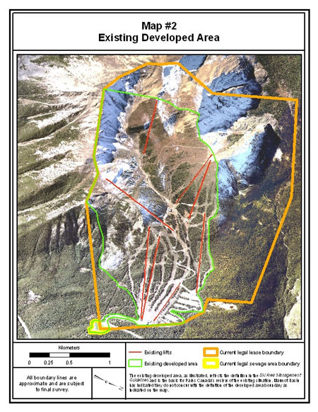
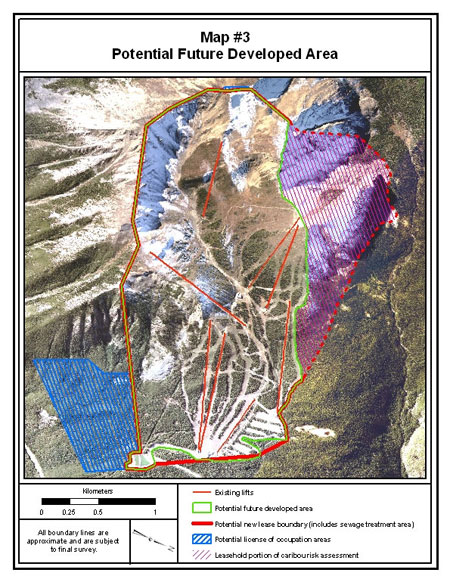
Site Guidelines
5.2 Ecological Management Parameters
Ski Area Management Guidelines
Background and Purpose
5.2.1 Vegetation, Terrain and Soil Ecological Parameters
5.2.2 Aquatic Ecological Parameters
5.2.3 Wildlife Ecological Parameters
5.3 Growth Limits and Ski Area Resort Balancing
Ski Area Management Guidelines
Objectives
Existing Situation
Site Guidelines
Existing Situation
Change
Permanent Growth Limit (future total)
Developed Area
361 ha
76 ha
437 ha
Ski Terrain
218 ha
57 ha
275 ha
Commercial Space
4,379 m 2
1,891 m 2
6,270 m 2
5.4 Ski Terrain/Run
Ski Area Management Guidelines
Objectives
Existing Situation
Site Guidelines
5.5 Ski Lifts
Ski Area Management Guidelines
Objectives
Existing Situation


Site Guidelines
6 A limited amount of grooming currently takes place in the upper portion of Outer Limits to reduce the potential for wind erosion of the snowpack. This is desirable to protect visitors and protect vegetation and as such can continue subject to application of Best Management Practices for grooming. 5.6 Visitor Safety - Terrain Modification
Ski Area Management Guidelines
Objectives
Existing Situation
Site Guidelines
5.7 Snowmaking and Support System
Ski Area Management Guidelines
Park Management Plan Direction
Objectives
Existing Situation
Site Guidelines

5.8 Facilities - Public Buildings, Accommodation and Operational Buildings
Ski Area Management Guidelines
Objectives
Existing Situation
Site Guidelines
5.9 Parking and Access
Ski Area Management Guidelines
Objectives

Existing Situation
Site Guidelines
5.10 Winter Activities
Ski Area Management Guidelines
Objectives
Existing Situation
Site Guidelines
5.11 Vegetation Management
Ski Area Management Guidelines
Park Management Plan Direction
Objectives
Existing Situation
Site Guidelines
5.12 Summer Use
Ski Area Management Guidelines
Park Management Plan Direction
Objectives
Existing Situation
Site Guidelines
5.13 National Park Experience and Education
Ski Area Management Guidelines
Objectives
Existing Situation
Site Guidelines
5.14 Environmental Stewardship
Ski Area Management Guidelines
Objectives
Existing Situation
Site Guidelines
5.15 Employee Accommodation
Ski Area Management Guidelines
Jasper Community Land Use Plan
Objectives
Existing Situation
Site Guidelines
5.16 Utilities and Infrastructure
Ski Area Management Guidelines
Objective
Existing Situation
Site Guidelines
6.0 Monitoring
7.0 Lease
Ski Area Management Guidelines
Objective
Existing Situation
Site Guidelines
8.0 Strategic Environmental Assessment (SEA)
Appendix 1: Ski Area Management Guidelines - December 7, 2006
SKI AREA MANAGEMENT GUIDELINES
INTRODUCTION
BASIC APPROACH
PRINCIPLES TO GUIDE NEW LONG RANGE PLANS
APPLICATION OF PRINCIPLES
Existing and potential summer use of ski areas presents ecological challenges beyond those of winter operations. There are more and different wildlife species that utilize ski area slopes in summer than in winter including sensitive species such as grizzly bears, woodland caribou, mountain goat, lynx and wolverine. Wildlife are particularly vulnerable during the spring and early summer because of sensitive life cycle requirements such as nesting and rearing newborn. In addition, several of the ski areas have important wildlife routes adjacent to the leaseholds or transecting them that are essential to the long-term health of wildlife populations.
• Alternatively, a ski area operator may elect to negotiate a new 42-year lease upon expiration of their current lease.
• The new lease will rationalize the leasehold boundary with the perimeter of the new Developed Area and reflect the negotiated Growth Limits. New leases will continue to be subject to legislation, regulations, policy and guidelines in force and as modified from time to time.PROJECTS IN ADVANCE OF A NEW LONG RANGE PLAN
• Lower chalet deck expansion
• Terrace Wing hotel replacement
• Temporary snowmaking on lower ski out
DEFINITIONS
The Developed Area represents the area modified for skiing or other uses within the leasehold through the construction of physical works, or through clearing/removal of trees and other vegetation, landscaping, terrain modification or other activity associated with ski area operation. It includes ski runs, lift lines, parking areas, commercial buildings, operational buildings and forested areas between ski runs. It does not include Undeveloped Areas, Un-serviced Terrain and Un-skied Terrain. The perimeter of the Developed Area will be determined by:
The maximum amount of development/resource utilization over time; represents build out.
Buildings and facilities can be replaced if they remain essentially the same. Lifts can be replaced, but the nature and location cannot. Buildings can be replaced with ones that have the same size, functions, capacity and location.
Outline the development and operation of the ski area for all seasons for a period of 5 to 15 years. Long-Range Plans will include an environmental management system and Best Management Practices. As required by the Canadian Environmental Assessment Act, ski area Long-Range Plans are subject to a comprehensive study. Following the approval of a Long-Range Plan, development, consistent with the plan, can proceed to the permitting stage without the need for additional environmental assessments.
An area that is lift accessible and regularly maintained to facilitate or improve visitor use and safety including the provision of signage, avalanche control, ski patrol, grooming, snowmaking, brushing, individual tree removal and access/egress.
Based on the Ski Area Management Guidelines, ski area specific Site Guidelines outline what development and use may be permitted, Growth Limits, the broad parameters for the type, nature and location of development and use and the approaches to enhance the character of the ski area’s operation to reflect its location in a national park and world heritage site. They provide direction for the preparation of Long-Range Plans. Site Guidelines are intended to guide development and use for the foreseeable future.
Ski terrain/run is an area that is routinely skied over the course of a normal ski day (subject to avalanche and snow conditions). The terrain includes alpine areas, formally cut runs/trails, gladed areas, cat tracks, roads, lift lines or connectors. The terrain has been developed or is serviced. It does not include areas that require ski touring, hiking, or climbing to access or egress areas that are not serviced.
An environmental gain is a positive change in key ecological conditions (wildlife movement and habitat, wildlife mortality, sensitive species/areas and aquatic ecosystems) that leads to the restoration or the long-term certainty of maintaining ecological integrity.
Appendix 2: Ski Area Planning Process
Vision (prepared by ski area with Parks Canada input)
Site Guidelines (prepared by Parks Canada with ski area input) [6 - 8 months]
Ski Area Long-Range Plan (LRP) (ski area prepares) [ 9 - 12 months]
CEA Agency Consultation on Comprehensive Study [minimum 3 months]
Decision on Long-Range Plan [minimum 2 months]
Project Permitting 11 (if LRP is approved)
Follow-up and Monitoring
9 Ski area prepares consultation strategy for LRP and CS for review and approval by Parks Canada.
10 Best Management Practices address ski hill routine projects and activities for which environmental effects are well known, predictable and can be largely managed though standardized environmental protection measures.
11 Once implementation of a Long Range-Plan is complete, the ski area may identify another suite of project proposals they wish to advance and prepare a new Long-Range Plan and associated comprehensive study based on the ski area Site Guidelines and proceed to the permitting stage once again, as outlined above, following approval of a new Long-Range Plan. Appendix 3: Strategic Environmental Assessment Summary
As part of the planning and development process for the ski area, Parks Canada, in collaboration with Marmot Basin, has prepared the Marmot Basin Site Guidelines . The guidelines describe possible development and use, set permanent limits to growth and provide direction for the foreseeable future.
Strategic Approach
Impact on Ecological Integrity
Vegetation, Terrain, Soils
Expected Ecological Outcomes
Management Parameters: Vegetation, Terrain, Soil
Aquatics
Expected Outcome
Management Parameters: Aquatic
Wildlife
Expected Outcomes
Management Parameters: Wildlife
Impact on the Visitor Experience
Expected Outcomes
Impact on Resources and Infrastructure
Expected Outcomes
Information Requirements
Legislation and Policy
Cumulative Effects/Conclusions
Ecological Integrity
Visitor Experience
Infrastructure Capacity
Conclusion
Appendix 4: Glossary
Development:
Development Footprint:
Harmonic Protection:
Heritage Tourism:
Infill:
Parameter:
Ski-way:
Use:
Warming Hut:
- Date modified :