
Wood Buffalo National Park wildfire updates
Wood Buffalo National Park
Report any wildfires or suspicious smoke to the Fire Duty Officer
867-621-0136
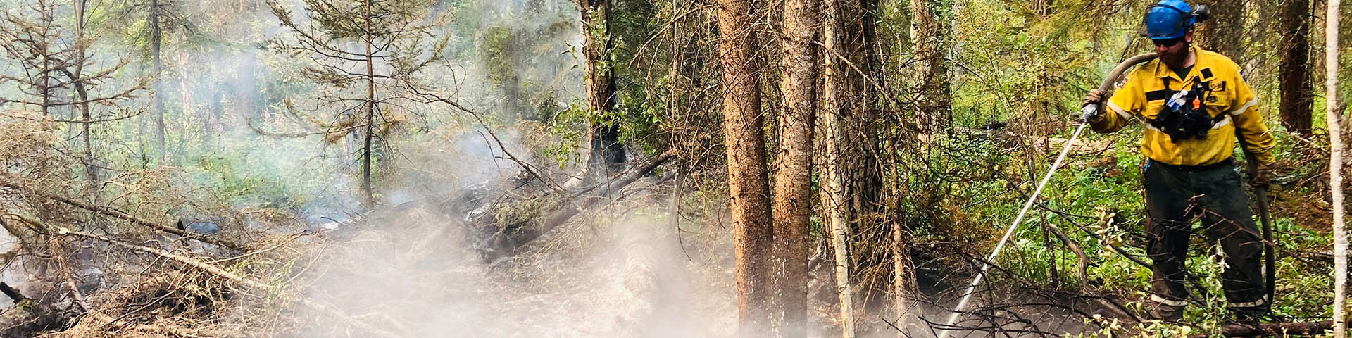
Safety is Parks Canada’s number one priority. Fire management personnel monitor Wood Buffalo National Park and surrounding areas for wildfire starts and are ready to respond if needed. Do your part and stay informed on the current fire danger status and park regulations.
Check this page regularly for updates on wildfire preparedness, response, and risk reduction activities in the park. Join our email notification lists to receive wildfire-related updates directly to your email. To be added, please email wbnpfire-feupnwb@pc.gc.ca.

2026 fire information updates
Fire Information Update – Monday June 22, 2026
The current fire danger level for Wood Buffalo National Park is VERY HIGH.
There is one new fire in Wood Buffalo National Park.
Klewi Complex (2026WB009, 2026WB004, SS004-26)
Location: This fire is on the northeastern side of Wood Buffalo National Park near the Whooping Crane nesting area, approximately 21 km northeast of Highway 5.
Status: This fire is estimated at 51,774 ha and is classified as being held.
Details: At this time, there is no threat to communities or infrastructure.
Resources: 50 personnel and 4 helicopters
The Klewi Complex is currently “being held” meaning the wildfire is not likely to spread beyond existent or predetermined boundaries under current and forecasted conditions.
With 100% containment achieved on the complex, stabilization of the incident and minimal fire activity, out-of-area resources are currently demobilizing and travelling back to their home locations. Wood Buffalo National Park fire management personnel will now manage this incident and action any fire activity as required.
Moving forward, Wood Buffalo National Park will issue fire information updates for the week on Fridays unless the situation changes. Updates will be shared on Facebook and posted on the park website: parks.canada.ca/wbnp-fire
Sprinklers continue to be maintained on values at Grande Détour and north of Salt River by GNWT wildfire management staff as a precaution.
There is no risk to communities, infrastructure or cabins at this time.
Report new fires to 1-877-NWT-FIRE (698-3473).
2026WB013
Location: This fire is located approximately 25 km north of Garden River and approximately 45 km southwest of Isidore Lake.
Status: Being Held
Details: Parks Canada fire crews actioned this new lightning-caused fire today. There is currently no threat to communities, infrastructure, or cabins.
2026WB008
Location: This fire is located approximately 28 km south of Peace Point, and 3 km south of the Peace River.
Status: This fire is estimated to be 1357.0 ha in size and is being held.
Details: This fire is exhibiting extremely low fire behaviour.
2026WB007 and 2026WB008
Status: These fires are being monitored, there is no change in size.
Details: Both fires are exhibiting low or no fire behaviour and no growth observed.
2026WB001, 2026WB002, 2026WB005, 2026WB010, 2026WB011 and 2026WB012
Status: These fires are classified as extinguished.
Current weather and forecast
Over the weekend, temperatures remained in the low 20s with light winds and no precipitation near the Klewi Complex. Today, temperatures reached mid 20s with light wind, no precipitation and partly cloudy skies.
This week, temperatures are expected to increase to the high 20s with light winds and no precipitation.
For more information, contact:
Fire information – Wood Buffalo National Park
867-621-0136
wbnpfire-feupnwb@pc.gc.ca
Report wildfires or suspicious smoke to the Fire Duty Officer at 867-621-0136.
For more information, visit: WBNP Fire Status Dashboard
Fire Information Update – Friday June 19, 2026
The current fire danger level for Wood Buffalo National Park is VERY HIGH.
There are no new fires in Wood Buffalo National Park.
Note: Wildfire area and perimeter length continue to be refined as more accurate data, including satellite imagery, are incorporated into mapping.
Klewi Complex (2026WB009, 2026WB004, SS004-26)
Location: This fire is on the northeastern side of Wood Buffalo National Park near the Whooping Crane nesting area, approximately 21 km northeast of Highway 5.
Status: This fire is estimated at 51,803 ha and is classified as being held.
Details: At this time, there is no threat to communities or infrastructure.
Resources: 125 personnel and 9 helicopters
As of this evening, the Klewi Complex perimeter is now 100% “contained” meaning the wildfire is not likely to spread beyond existent or predetermined boundaries under current and forecasted conditions.
Crews continue to address the few remaining areas of fire activity that require action along the eastern flank.
With this progress, incident personnel and resources are working to process surplus equipment and demobilize as needed. As resources are released, Wood Buffalo National Park fire management personnel will closely monitor the wildfire perimeter and suppress any fire activity if needed.
Today, the last remaining resources from the GWNT Forest Management Division assigned to the Klewi Complex have been released. Parks Canada is extremely grateful to assisting agencies including the Government of Northwest Territories for their support in managing this incident.
Sprinklers continue to be maintained on values at Grande Détour and north of Salt River by GNWT wildfire management staff as a precaution.
There is no risk to communities, infrastructure or cabins at this time.
Report new fires to 1-877-NWT-FIRE (698-3473).
2026WB006, 2026WB007, and 2026WB008
Status: These fires remain under their previous classifications with no change in size.
Details: Rainfall across the park contributed to reduced fire activity, with all fires exhibiting low or no fire behaviour and no growth observed.
2026WB001, 2026WB002, 2026WB005, 2026WB010, 2026WB011 and 2026WB012
Status: These fires are classified as extinguished.
Current weather and forecast
Yesterday, temperatures reached 19°C with partly cloudy skies, light to moderate winds and no precipitation. Cooler conditions prevailed today with a high of 17°C, mixed clouds, light winds and no precipitation.
Warmer temperatures are expected tomorrow with a high of 20°C, light winds, partly cloudy skies and trace precipitation. There is a possibility of lightning later in the day.
For more information, contact:
Fire Information Officer
250-299-3957
pc-imt-io@pc.gc.ca
Report wildfires or suspicious smoke to the Fire Duty Officer at 867-621-0136.
For more information, visit: WBNP Fire Status Dashboard
Fire Information Update – Wednesday June 17, 2026
The current fire danger level for Wood Buffalo National Park is VERY HIGH.
There are no new fires in Wood Buffalo National Park.
Note: Wildfire area and perimeter length continue to be refined as more accurate data, including satellite imagery, are incorporated into mapping.
Klewi Complex (2026WB009, 2026WB004, SS004-26)
Location: This fire is on the northeastern side of Wood Buffalo National Park near the Whooping Crane nesting area, approximately 21 km northeast of Highway 5.
Status: This fire is estimated at 52,116 ha and is classified as being held.
Details: At this time, there is no threat to communities or infrastructure.
Resources: 151 personnel and 11 helicopters
Thanks to the exceptional work of incident response personnel, as of yesterday, the Klewi Complex has been classified as “being held”. This means the wildfire is not likely to spread beyond existent or predetermined boundaries under current and forecasted conditions.
Currently, 359 km of the approximately 403 km total perimeter is considered “contained” or “controlled”.
Crews continue to make steady progress toward full control of the complex with support from helicopter bucketing. Nightly infrared drone scans are ongoing to identify remaining hot spots and support targeted suppression efforts.
Reminder: a NOTAM remains in effect for the airspace around this fire until further notice. A NOTAM establishes controlled airspace which prevents non-incident-related aircraft including drones from entering and colliding with firefighting aircraft.
Sprinklers continue to be maintained on values at Grande Détour and north of Salt River by GNWT wildfire management staff as a precaution.
There is no risk to communities, infrastructure or cabins at this time.
Report new fires to 1-877-NWT-FIRE (698-3473).
2026WB008
Location: This fire is located approximately 28 km south of Peace Point, and 3 km south of the Peace River.
Status: This fire is estimated to be 1357.0 ha in size and is being held.
Details: This fire is exhibiting extremely low fire behaviour, with recent rainfall across the park and cooler temperatures.
2026WB007
Location: This fire is located approximately 65 km northeast of Garden River and approximately 9 km southeast of Isidore Lake.
Status: This fire remains under its previous classification with no change in size.
Details: There is currently no threat to communities, infrastructure, or cabins.
2026WB006
Location: This fire is located approximately 82 km northeast of Garden River and approximately 19 km northeast of Isidore Lake.
Status: This fire is estimated to be 659 ha in size and is being monitored.
Details: Fire crews have observed no fire behaviour in recent surveys. There is currently no threat to communities, infrastructure, or cabins at Isidore Lake.
2026WB001, 2026WB002, 2026WB005, 2026WB010, 2026WB011 and 2026WB012
Status: These fires are classified as extinguished.
Current weather and forecast
Yesterday, temperatures reached 22°C with partly cloudy skies, light winds and no precipitation. Similar conditions continued into today with a high of 21°C, scattered clouds, light winds and no precipitation.
Cooler temperatures are expected tomorrow with a high of 20°C, light winds, partly cloudy skies and no precipitation.
For more information, contact:
Fire Information Officer
250-299-3957
pc-imt-io@pc.gc.ca
Report wildfires or suspicious smoke to the Fire Duty Officer at 867-621-0136.
For more information, visit: WBNP Fire Status Dashboard
Fire Information Update – Tuesday June 16, 2026
The current fire danger level for Wood Buffalo National Park is VERY HIGH.
There are no new fires in Wood Buffalo National Park.
Klewi Complex (2026WB009, 2026WB004, SS004-26)
Location: This fire is on the northeastern side of Wood Buffalo National Park near the Whooping Crane nesting area, approximately 21 km northeast of Highway 5.
Status: This fire is estimated at 52,154 ha and is classified as out of control.
Details: At this time, there is no threat to communities or infrastructure.
Resources: 192 personnel and 13 helicopters
Note: While the size of the fire has not changed, wildfire area and perimeter length continue to be refined as more accurate data, including satellite imagery, are incorporated into mapping.
Wildfire response activities continue to stabilize and progress toward containment. Approximately 330 km of the perimeter (about 397 km in total) is now classified as contained or controlled.
Warm and dry conditions are helping fire crews locate the few remaining areas of fire activity that require action before full containment is achieved.
Previous infrared drone scanning along 52 km of the southwest perimeter identified only 2 “hotspots” that require action. Scanning will continue in priority areas along the north and east perimeter in the coming days.
As progress continues toward incident objectives and fire activity remains stable, updates will be provided on Wednesday and Friday this week unless conditions change. This adjustment reflects the positive trajectory of the response while ensuring timely, accurate information continues to be shared. Update frequency will be reassessed next week based on conditions.
Sprinklers continue to be maintained on values at Grande Détour and north of Salt River by GNWT wildfire management staff as a precaution.
There is no risk to communities, infrastructure or cabins at this time.
Report new fires to 1-877-NWT-FIRE (698-3473).
2026WB006, 2026WB007, and 2026WB008
Status: These fires remain under their previous classifications with no change in size.
Surveys across all three fires were conducted by crews today, with low or no fire behaviour observed. There is currently no threat to communities, infrastructure, or cabins. Structural protection measures remain in place for cabins at Isidore Lake as a precaution.
2026WB001, 2026WB002, 2026WB005, 2026WB010, 2026WB011 and 2026WB012
Status: These fires are classified as extinguished.
Current weather and forecast
Yesterday, temperatures reached 26°C with sunny skies, minimal cloud cover, light winds and no precipitation.
Today, a high of 23°C is expected with light to moderate winds and no precipitation in the forecast.
For more information, contact:
Fire Information Officer
250-299-3957
pc-imt-io@pc.gc.ca
Report wildfires or suspicious smoke to the Fire Duty Officer at 867-621-0136.
For more information, visit: WBNP Fire Status Dashboard
Fire Information Update – Monday June 15, 2026
The current fire danger level for Wood Buffalo National Park is HIGH.
There are no new fires in Wood Buffalo National Park.
Klewi Complex (2026WB009, 2026WB004, SS004-26)
Location: This fire is on the northeastern side of Wood Buffalo National Park near the Whooping Crane nesting area, approximately 21 km northeast of Highway 5.
Status: This fire is estimated at 52,236 ha and is classified as out of control.
Details: At this time, there is no threat to communities or infrastructure.
Resources: 201 personnel and 13 helicopters
Note: While the size of the fire has not changed, wildfire area and perimeter length continue to be refined as more accurate data, including satellite imagery, are incorporated into mapping.
Containment efforts continue to progress well on all sides of the wildfire. Currently, 270 km of the total wildfire perimeter (approximately 386 km) is now considered “contained” or “controlled”.
Again yesterday, fire activity generally remained low across most of the complex. Three areas of increased activity along the north and west perimeter were actioned by ground crews supported by helicopter bucketing.
Previous infrared drone scanning along 66 km of the northern perimeter identified only 6 “hotspots” that require further action in the coming days.
Reminder: a NOTAM remains in effect for the airspace around this fire until further notice. A NOTAM establishes controlled airspace which prevents non-incident-related aircraft including drones from entering and colliding with firefighting aircraft.
Sprinklers continue to be maintained on values at Grande Détour and north of Salt River by GNWT wildfire management staff as a precaution.
There is no risk to communities, infrastructure or cabins at this time.
Report new fires to 1-877-NWT-FIRE (698-3473).
2026WB006, 2026WB007, and 2026WB008
Status: These fires remain under their previous classifications with no change in size.
Fire crews have observed extremely low fire behaviour with recent rainfall and cooler temperatures. There is currently no threat to communities, infrastructure, or cabins. Structural protection measures remain in place for cabins at Isidore Lake as a precaution.
2026WB001, 2026WB002, 2026WB005, 2026WB010, 2026WB011 and 2026WB012
Status: These fires are classified as extinguished.
Current weather and forecast
Yesterday, temperatures reached 24°C with sunny skies, minimal cloud cover, light winds and trace precipitation in isolated areas.
Today, temperatures are expected to increase to 27°C with light winds and no precipitation.
For more information, contact:
Fire Information Officer
250-299-3957
pc-imt-io@pc.gc.ca
Report wildfires or suspicious smoke to the Fire Duty Officer at 867-621-0136.
For more information, visit: WBNP Fire Status Dashboard
Fire Information Update – Sunday June 14, 2026
The current fire danger level for Wood Buffalo National Park is MODERATE.
There are no new fires in Wood Buffalo National Park.
Klewi Complex (2026WB009, 2026WB004, SS004-26)
Location: This fire is on the northeastern side of Wood Buffalo National Park near the Whooping Crane nesting area, approximately 21 km northeast of Highway 5.
Status: This fire is estimated at 52,319 ha and is classified as out of control.
Details: At this time, there is no threat to communities or infrastructure.
Resources: 201 personnel and 13 helicopters
Note: While the size of the fire has not changed or grown, wildfire area and perimeter length continue to be refined as more accurate data, including satellite imagery, are incorporated into mapping.
Further progress was made towards containment of the wildfire yesterday, with approximately 219 km of the total perimeter (currently 378 km) now considered “contained” or “controlled”.
- "Contained” fire perimeter means this portion of wildfire is not likely to spread beyond existent or predetermined boundaries under current and forecasted conditions.
- “Controlled” perimeter means this portion of the wildfire has received sufficient suppression action to ensure no further spread of the fire.
Infrared drone scanning along 25 km of the norther perimeter identified only 8 “hotspots” that will be actioned to further strengthen of containment lines.
As of today, Parks Canada and Northwest Territories have made the decision to dissolve unified command for the Klewi Complex. This change was made by both organizations in light of significant containment progress and low risk of further fire spread outside the park boundary, beyond the current perimeter. Moving forward, Parks Canada will continue to manage this incident with support from NWT Fire and other assisting agencies. Incident management priorities remain the same – contain spread of fire towards communities and values at risk, as well as minimizing impacts on endangered whooping cranes in the area.
Reminder: a NOTAM remains in effect for the airspace around this fire until further notice. A NOTAM establishes controlled airspace which prevents non-incident-related aircraft including drones from entering and colliding with firefighting aircraft.
Sprinklers continue to be maintained on values at Grande Détour and north of Salt River by GNWT wildfire management staff as a precaution.
There is no risk to communities, infrastructure or cabins at this time.
Report new fires to 1-877-NWT-FIRE (698-3473).
2026WB012
Location: This fire is located approximately 30 km north of Garden River.
Status: This fire is now classified as EXTINGUISHED.
Suppression efforts from Parks Canada crews this week have been successful, and this fire is now extinguished.
2026WB006, 2026WB007, and 2026WB008
Fire crews have observed extremely low fire behaviour with recent rainfall and cooler temperatures. There is currently no threat to communities, infrastructure, or cabins. Structural protection measures remain in place for cabins at Isidore Lake as a precaution.
2026WB001, 2026WB002, 2026WB005, 2026WB010, 2026WB011 and 2026WB012
Status: These fires are classified as extinguished.
Current weather and forecast
Yesterday, temperatures reached 26°C with sunny skies, light winds and no precipitation.
Today, similar conditions are forecasted to be a high of 24°C with light to moderate winds. No precipitation is expected.
For more information, contact:
Fire Information Officer
250-299-3957
pc-imt-io@pc.gc.ca
Report wildfires or suspicious smoke to the Fire Duty Officer at 867-621-0136.
For more information, visit: WBNP Fire Status Dashboard
Fire Information Update – Saturday June 13, 2026
The current fire danger level for Wood Buffalo National Park is LOW.
There are no new fires in Wood Buffalo National Park.
Klewi Complex (2026WB009, 2026WB004, SS004-26)
Location: This fire is on the northeastern side of Wood Buffalo National Park near the Whooping Crane nesting area, approximately 21 km northeast of Highway 5.
Status: This fire is estimated at 53,609 ha and is classified as out of control.
Details: At this time, there is no threat to communities or infrastructure.
Resources: 205 personnel and 13 helicopters
Note: Fire size estimates have recently been updated to reflect more accurate mapping. As crews gain improved access and use updated data, fire perimeters are refined, which can result in noticeable changes to reported fire sizes. These updates do not necessarily indicate recent fire growth, but rather improved measurement accuracy.
Crews continued to make great progress towards containment of the wildfire perimeter. As of yesterday evening, around 178 km of the total perimeter length (currently 343 km) is now considered “contained” or “controlled”.
- "Contained” fire perimeter means this portion of wildfire is not likely to spread beyond existent or predetermined boundaries under current and forecasted conditions.
- “Controlled” perimeter means this portion of the wildfire has received sufficient suppression action to ensure no further spread of the fire.
Most of the secured perimeter is located along the north, east and south flanks of the fire where further wildfire growth would pose the greatest risk to incident management priorities. These priorities remain the same – protecting human life, communities, infrastructure, and other values at risk, while also minimizing impacts on whooping cranes, a species at risk.
Recent infrared drone scanning identified 44 hotspots along a 23 km stretch of the eastern perimeter. These areas were actioned today by fire crews. Last evening, further scanning was completed to identify hotspots near the northern perimeter to be actioned in the coming days.
Reminder: a NOTAM remains in effect for the airspace around this fire until further notice. A NOTAM establishes controlled airspace which prevents non-incident-related aircraft including drones from entering and colliding with firefighting aircraft.
Sprinklers continue to be maintained on values at Grande Détour and north of Salt River by GNWT wildfire management staff as a precaution.
There is no risk to communities, infrastructure or cabins at this time.
Report new fires to 1-877-NWT-FIRE (698-3473).
2026WB012
Location: This fire is located approximately 30 km north of Garden River.
Status: This fire is estimated to be 0.2 ha in size and is now classified as under control.
Parks Canada fire crews have undertaken ground suppression efforts, and this fire is now classified as under control.
2026WB008
Location: This fire is located approximately 28 km south of Peace Point, and 3 km south of the Peace River.
Status: This fire is estimated to be 1,533 ha in size and is classified as out of control.
This fire is exhibiting extremely low fire behaviour, with recent rainfall across the park and cooler temperatures.
2026WB007
Location: This fire is located approximately 65 km northeast of Garden River and approximately 9 km southeast of Isidore Lake.
Status: This fire is estimated to be 35 ha in size and is classified as out of control.
Recent rainfall and cooler temperatures across the park have contributed to reduced fire activity. No growth observed.
2026WB006
Location: This fire is located approximately 82 km northeast of Garden River and approximately 19 km northeast of Isidore Lake.
Status: This fire is estimated to be 908 ha in size and is classified as out of control.
Fire crews have observed extremely low fire behaviour with recent rainfall and cooler temperatures. There is currently no threat to communities, infrastructure, or cabins at Isidore Lake. Structural protection measures remain in place for cabins at Isidore Lake as a precaution.
2026WB001, 2026WB002, 2026WB005, 2026WB010 and 2026WB011
Status: These fires are classified as extinguished.
Current weather and forecast
Yesterday, temperatures reached 22°C with sunny skies, light winds and no precipitation.
Today, similar conditions are forecasted with a high of 22°C and light winds. No precipitation is expected.
For more information, contact:
Fire Information Officer
250-299-3957
pc-imt-io@pc.gc.ca
Report wildfires or suspicious smoke to the Fire Duty Officer at 867-621-0136.
For more information, visit: WBNP Fire Status Dashboard
Fire Information Update – Friday June 12, 2026
The current fire danger level for Wood Buffalo National Park is LOW.
There are no new fires in Wood Buffalo National Park.
Klewi Complex (2026WB009, 2026WB004, SS004-26)
Location: This fire is on the northeastern side of Wood Buffalo National Park near the Whooping Crane nesting area, approximately 21 km northeast of Highway 5.
Status: This fire is estimated at 53,588 ha and is classified as out of control.
Details: At this time, there is no threat to communities or infrastructure.
Resources: 198 personnel and 13 helicopters
Note: Fire size estimates have recently been updated to reflect more accurate mapping. As crews gain improved access and use updated data, fire perimeters are refined, which can result in noticeable changes to reported fire sizes. These updates do not necessarily indicate recent fire growth, but rather improved measurement accuracy.
Operations yesterday focused primarily on advancing containment efforts along all sides of the fire perimeter. Crews from Parks Canada, the Northwest Territories (NWT), Alberta, and British Columbia worked to establish and strengthen containment lines near the perimeter.
This work will continue over the next several days, with the objective of securing a 100-foot perimeter in areas where fire growth remains a risk. Bucketing helicopters are also continuing to support ground crews, helping reinforce containment efforts from above.
Previous infrared drone scanning identified 49 hotspots along a 35 km section of the northeast perimeter. Additional scanning was completed last night along the east perimeter to identify any further hotspots in the area. Identifying these areas significantly reduces the risk of fire spread, as crews can extinguish them before they develop into spot fires beyond the perimeter.
Sprinklers continue to be maintained on values at Grande Détour and north of Salt River by GNWT wildfire management staff as a precaution.
There is no risk to communities, infrastructure or cabins at this time.
Report new fires to 1-877-NWT-FIRE (698-3473).
2026WB012
Status: Being held
Fire crews conducted suppression operations on this fire today, with support from helicopter bucketing. This fire continues to exhibit low fire behaviour.
2026WB006, 2026WB007, and 2026WB008
Status: These fires remain under their previous classifications with no change in size.
Recent rainfall and cooler temperatures across the park have contributed to reduced fire activity, with all fires exhibiting low fire behaviour and no growth observed. There is currently no threat to communities, infrastructure, or cabins at Isidore Lake. Structural protection measures remain in place for cabins at Isidore Lake as a precaution.
2026WB001, 2026WB002, 2026WB005, 2026WB010 and 2026WB011
These fires are classified as extinguished.
Weather and forecast
Yesterday, overcast conditions shifted to partly cloudy skies with a maximum temperature of 16°C, no precipitation, and lighter winds.
Today, temperatures will increase to a high of 18°C with light winds and no precipitation expected.
For more information, contact:
Fire Information Officer
250-299-3957
pc-imt-io@pc.gc.ca
Report wildfires or suspicious smoke to the Fire Duty Officer at 867-621-0136.
For more information, visit: WBNP Fire Status Dashboard
Fire Information Update – Thursday June 11, 2026
The current fire danger level for Wood Buffalo National Park is LOW.
There are no new fires in Wood Buffalo National Park.
Klewi Complex (2026WB009, 2026WB004, SS004-26)
Location: This fire is on the northeastern side of Wood Buffalo National Park near the Whooping Crane nesting area, approximately 21 km northeast of Highway 5.
Status: This fire is estimated at 53,124 ha and is classified as out of control.
Details: At this time, there is no threat to communities or infrastructure.
Resources: 195 personnel, 12 helicopters and 6 fuel bowsers (The temporary increase in personnel is due to transition periods as individuals reaching their maximum time on the incident are replaced).
Note: Fire size estimates have recently been updated to reflect more accurate mapping. As crews gain improved access and use updated data, fire perimeters are refined, which can result in noticeable changes to reported fire sizes. These updates do not necessarily indicate recent fire growth, but rather improved measurement accuracy.
Yesterday, improved flying conditions allowed aerial and ground operations to resume on the Klewi Complex. Incident management priorities remain the same – prevent spread of fire towards communities and values at risk, as well as minimizing impacts on whooping cranes in the area.
Recent precipitation has temporarily reduced fire activity throughout the wildfire area and operations staff are using this to make progress towards containment. Along the northeast perimeter, crews made progress on containment to prevent further spread beyond the national park boundary. Similar work towards containment was conducted along the north and south edges of the fire with support from bucketing helicopters.
Last evening, infrared drone scanning was completed along the northern edge of the perimeter to identify fire hotspots that can be actioned in the coming days. This work will reduce the likelihood of fire spread to the north.
Sprinklers continue to be maintained on values at Grande Détour and north of Salt River by GNWT wildfire management staff as a precaution.
There is no risk to communities, infrastructure or cabins at this time.
Report new fires to 1-877-NWT-FIRE (698-3473).
2026WB012, 2026WB008, 2026WB007, and 2026WB006
Status: These fires remain under their previous classifications with no change in size.
Rainfall across the park contributed to reduced fire activity, with all fires exhibiting low fire behaviour and no growth observed. There is currently no threat to communities, infrastructure, or cabins at Isidore Lake. Structural protection measures remain in place for cabins at Isidore Lake as a precaution.
2026WB001, 2026WB002, 2026WB005, 2026WB010 and 2026WB011
These fires are classified as extinguished.
Weather and forecast
Yesterday, overcast conditions shifted to partly cloudy skies with a maximum temperature of 16°C, no precipitation, and lighter winds.
Today, temperatures will increase to a high of 18°C with light winds and no precipitation expected.
For more information, contact:
Fire Information Officer
250-299-3957
pc-imt-io@pc.gc.ca
Report wildfires or suspicious smoke to the Fire Duty Officer at 867-621-0136.
For more information, visit: WBNP Fire Status Dashboard
Fire Information Update – Wednesday June 10, 2026
The current fire danger level for Wood Buffalo National Park is LOW.
There are no new fires in Wood Buffalo National Park.
Klewi Complex (2026WB009, 2026WB004, SS004-26)
Location: This fire is on the northeastern side of Wood Buffalo National Park near the Whooping Crane nesting area, approximately 21 km northeast of Highway 5.
Status: This fire is estimated at 53,124 ha and is classified as out of control.
Details: At this time, there is no threat to communities or infrastructure.
Resources: 244 personnel, 17 helicopters and 6 fuel bowsers (The temporary increase in personnel is due to transition periods as individuals reaching their maximum time on the incident are replaced).
Note: Fire size estimates have recently been updated to reflect more accurate mapping. As crews gain improved access and use updated data, fire perimeters are refined, which can result in noticeable changes to reported fire sizes. These updates do not necessarily indicate recent fire growth, but rather improved measurement accuracy.
Again yesterday, unfavourable flying conditions prevented operations staff from accessing the fire perimeter. Fire crews used this opportunity to complete mandatory safety briefings and stretcher exercises to maintain important safety-related skills.
No infrared drone scanning was completed overnight due to inclement weather. Further scanning is planned along the northeast perimeter of the wildfire once conditions allow, near the Little Buffalo River. This will help identify “hot spots” of fire activity that can be actioned when crews can access the perimeter.
Yesterday, Parks Canada’s National Incident Management Team Charlie completed their transition with Team Bravo and have assumed command of the incident for Parks Canada. The Klewi Wildfire Complex continues to be managed in a unified command structure with the Government of Northwest Territories (GNWT). This structure is expected to remain active for the foreseeable future.
Sprinklers continue to be maintained on values at Grande Détour and north of Salt River by GNWT wildfire management staff as a precaution.
There is no risk to communities, infrastructure or cabins at this time.
Report new fires to 1-877-NWT-FIRE (698-3473).
2026WB012, 2026WB008, 2026WB007, and 2026WB006
Status: These fires remain under their previous classifications with no change in size.
Details: Rainfall across the park contributed to reduced fire activity, with all fires exhibiting low fire behaviour and no growth observed. There is currently no threat to communities, infrastructure, or cabins at Isidore Lake. Structural protection measures remain in place for cabins at Isidore Lake as a precaution.
2026WB001, 2026WB002, 2026WB005, 2026WB010 and 2026WB011
These fires are classified as extinguished.
Current weather and forecast
Yesterday, overcast skies and steady rain continued through mid-morning, with scattered rain into the afternoon. Light winds were present with gusts up to 25 km/h through the afternoon.
Today, temperatures are expected to reach a maximum of 12°C with scattered clouds and light rain possible throughout the day. Winds are forecasted at 15 km/h gusting up to 25 km/h.
Although decreased temperatures and increased humidity are favourable for wildland firefighting efforts, these conditions are not uniform across the fire perimeter. Certain areas are receiving more precipitation than others. Long-term drought conditions in the area mean substantial precipitation is required to meaningfully change the fire situation.
For more information, contact:
Fire Information Officer
250-299-3957
pc-imt-io@pc.gc.ca
Report wildfires or suspicious smoke to the Fire Duty Officer at 867-621-0136.
For more information, visit: WBNP Fire Status Dashboard
Fire Information Update – Tuesday June 9, 2026
The current fire danger level for Wood Buffalo National Park is LOW.
There are no new fires in Wood Buffalo National Park.
Note: Fire size estimates have recently been updated to reflect more accurate mapping. As crews gain improved access and use updated data, fire perimeters are refined, which can result in noticeable changes to reported fire sizes. These updates do not necessarily indicate recent fire growth, but rather improved measurement accuracy.
Klewi Complex (2026WB009, 2026WB004, SS004-26)
Location: This fire is on the northeastern side of Wood Buffalo National Park near the Whooping Crane nesting area, approximately 22 km northeast of Highway 5.
Status: This fire is estimated at 53,124 ha and is classified as out of control.
Details: At this time, there is no threat to communities or infrastructure.
Resources: 244 personnel, 15 helicopters and 6 fuel bowsers
Aircraft operations were suspended yesterday due to safety concerns created by a 200-foot ceiling between the treetops and cloud cover. Crews, while unable to access the fire due to its roadless location, spent the day refurbishing and maintaining equipment, as well as assessing potential helicopter landing sites along Highway 5 for future instances when inclement weather prevents aircraft from landing in Fort Smith.
Sunday night’s infra-red scan revealed more than 600 hot spots along 34 km of the southern perimeter. A hot spot is any remaining source of heat after the main fire front has passed. It can include smouldering roots or stumps, burning organic material in soil, partially burned logs or debris. Hot spots often don’t have visible flames, but they can hold heat for days or weeks. If a hot spot is close to the fire perimeter, it can cross containment lines and start spot fires outside the line. Crews, with bucketing helicopter support, will work in this area once the ceiling improves. Weather permitting, another infrared scan will occur overnight, starting at the Little Buffalo River and moving south along the eastern flank of the fire.
Yesterday, Team Bravo, Parks Canada’s outgoing incident management team, spent the day completing evaluations and preparing for the arrival of Team Charlie. A full day of transition is planned for today, with Team Charlie assuming command on the Parks Canada side Wednesday morning. Team Charlie will continue to work under a Unified Command with GNWT Fire.
Sprinklers continue to be maintained on values at Grande Détour and north of Salt River by GNWT wildfire management staff as a precaution.
There is no risk to communities, infrastructure or cabins at this time.
Report new fires to 1-877-NWT-FIRE (698-3473).
2026WB012, 2026WB008, 2026WB007, and 2026WB006
Status: These fires remain under their previous classifications with no change in size.
Details: Rainfall across the park contributed to reduced fire activity, with all fires exhibiting low fire behaviour and no growth observed. There is currently no threat to communities, infrastructure, or cabins at Isidore Lake. Structural protection measures remain in place for cabins at Isidore Lake as a precaution.
2026WB001, 2026WB002, 2026WB005, 2026WB010 and 2026WB011
These fires are classified as extinguished.
Weather
Steady rain tapers by mid-morning, with light showers lingering. High of 11°C, with north winds shifting to north-northwest at 10 km/h, gusting to 25 km/h early this afternoon. Tomorrow, cloudy, high of 13 °C with light rain.
While 25 mm fell on the fire yesterday, it’s important to keep in mind that a handful of rainy days won’t be enough to extinguish the fire.
For more information, contact:
Fire Information Officer
403-497-4989
pc-imt-io@pc.gc.ca
Report wildfires or suspicious smoke to the Fire Duty Officer at 867-621-0136.
For more information, visit: WBNP Fire Status Dashboard
Fire Information Update – Monday, June 8, 2026
The current fire danger level for Wood Buffalo National Park is HIGH.
There are no new fires in Wood Buffalo National Park.
Note: Fire size estimates have recently been updated to reflect more accurate mapping. As crews gain improved access and use updated data, fire perimeters are refined, which can result in noticeable changes to reported fire sizes. These updates do not necessarily indicate recent fire growth, but rather improved measurement accuracy.
Klewi Complex (2026WB009, 2026WB004, SS004-26)
Location: This fire is on the northeastern side of Wood Buffalo National Park near the Whooping Crane nesting area, approximately 22 km northeast of Highway 5.
Status: This fire is an estimated at 52,966 ha and is classified as out of control.
Details: At this time, there is no threat to communities or infrastructure.
Resources: 176 personnel, 15 helicopters and 6 fuel bowsers
Yesterday’s favourable weather conditions set the stage for a series of targeted ignitions in the bay between the two north fingers of the fire. While this increased the size of the fire, it lessened the fuel load in this area. This will give our crews an advantage to secure this area of the perimeter. While significant progress was made yesterday, crews and heavy helicopters will continue the arduous good work in the area in the days to come.
Ground crews and air support continued to work the perimeter on all sides of the fire, ensuring the fire line is cool.
Last night’s infra-red scan revealed more than 600 hot spots along 34 km of the southern perimeter. A hot spot is any remaining source of heat after the main fire front has passed. It can include smouldering roots or stumps, burning organic material in soil, partially burned logs or debris. Hot spots often don’t have visible flames, but they can hold heat for days or weeks. If a hot spot is close to the fire perimeter, it can cross containment lines and start spot fires outside the line. Crews, with the assistance of bucketing helicopters, will be actively working to remove these sources of heat today.
Fighting wildfires takes teamwork. Ground crews, overhead personnel, contractors, and air support are all working together toward one goal: containing the fire. With improving weather conditions on their side, crews are making steady progress on suppression efforts.
Sprinklers continue to be maintained on values at Grande Détour and north of Salt River by GNWT wildfire management staff as a precaution. There is no risk to communities, infrastructure or cabins at this time. Report new fires to 1-877-NWT-FIRE (698-3473).
2026WB012
Location: This fire is located approximately 30 km north of Garden River.
Status: This fire is estimated to be 0.2 ha in size and is classified as being held.
Yesterday, fire crews were unable to access this fire due to bear activity, however; the fire was observed to be exhibiting low fire behaviour.
2026WB008
Location: This fire is located approximately 28 km south of Peace Point, and 3 km south of the Peace River.
Status: This fire is estimated to be 752 ha in size and is classified as out of control.
Details: Yesterday, fire activity remained low due to cooler temperatures, with no growth observed. The fire continues to be monitored, and there is currently no threat to communities or infrastructure.
2026WB007
Location: This fire is located approximately 65 km northeast of Garden River and approximately 9 km southeast of Isidore Lake.
Status: This fire is estimated to be 35 ha in size and is classified as out of control.
Details: Yesterday, fire activity remained low due to cooler temperatures, with no growth observed. As a precaution, structural protection measures remain in place for cabins at Isidore Lake; however, there is currently no threat to these structures.
2026WB006
Location: This fire is located approximately 82 km northeast of Garden River and approximately 19 km northeast of Isidore Lake.
Status: This fire is estimated to be 538 ha in size and is classified as out of control.
Details: Yesterday, fire activity remained low due to cooler temperatures, with no growth observed. As a precaution, structural protection measures remain in place for cabins at Isidore Lake; there is currently no threat to these structures.
2026WB001, 2026WB002, 2026WB005, 2026WB010 and 2026WB011
These fires are classified as extinguished.
Weather
Rain today with a high of 12 °C today. Winds northeast shifting to north 15 km/h gusting to 30 km/h early this afternoon. Rain is expected to intensify overnight.
For more information, contact:
Fire Information Officer
403-497-4989
pc-imt-io@pc.gc.ca
Report wildfires or suspicious smoke to the Fire Duty Officer at 867-621-0136.
For more information, visit: WBNP Fire Status Dashboard
Fire Information Update – Sunday, June 7, 2026
The current fire danger level for Wood Buffalo National Park is HIGH.
There are no new fires in Wood Buffalo National Park.
Fire size estimates have recently been updated to reflect more accurate mapping. As crews gain improved access and use updated data, fire perimeters are refined, which can result in noticeable changes to reported fire sizes. These updates do not necessarily indicate recent fire growth, but rather improved measurement accuracy.
Klewi Complex (2026WB009, 2026WB004, SS004-26)
Location: This fire is on the northeastern side of Wood Buffalo National Park near the Whooping Crane nesting area, approximately 22 km northeast of Highway 5.
Status: This fire is an estimated at 52,130 ha and is classified as out of control.
Details: At this time, there is no threat to communities or infrastructure.
Resources: 146 personnel, 15 helicopters and 6 fuel bowsers.
Crews had a productive day yesterday thanks to cooler and wetter conditions.
Crews continued efforts to safely connect the two northern fingers of the fire using planned ignitions. Yesterday, specialists burned unburned fuels between them, working northward and using north winds to bring fire into previously burned areas. Heavy helicopters continue to support these efforts, which should cool the area enough for ground crews to access it today.
Ground crews, supported by bucketing and heavy helicopters, pumps, and aerial ignition, have secured all fire within the NWT east of the Little Buffalo River along the east side of the fire’s northern finger. The fire line is close to being held.
Ground and air crews continued to work south of the Buffalo River on the mid-eastern side of the fire as it continues to hold heat. Sustained use of various types of helicopters to cool off the area for additional work by ground crews today.
In the south-eastern portion of the fire, Parks Canada and Alberta crews supported by bucketing helicopters, continue to secure the perimeter, with crews continuing to make their way west and north. At the bottom of the northwest corner of the fire, crews are actioning hotspots and looking for opportunities for small-scale hand ignitions to burn out unburned fuel this weekend.
These various methods of perimeter work are crucial, because perimeter is where the fire continues to grow. By working along the edges, they can stop the fire from spreading into new areas, while the interior typically burns out on its own.
Sprinklers continue to be maintained on values at Grande Détour and north of Salt River by GNWT wildfire management staff as a precaution.
There is no risk to communities, infrastructure or cabins at this time. Report new fires to 1-877-NWT-FIRE (698-3473).
An overnight infrared scanning flight along the northwest perimeter identified fewer hotspots than anticipated. This technology enables crews to detect residual heat, beyond visible flames, improving the speed, safety, and effectiveness of suppression operations.
2026WB012
Location: This fire is located approximately 30 km north of Garden River.
Status: This fire is estimated to be 0.2 ha in size and is classified as being held.
Details: Yesterday, the Alberta Wildfire crew finished building the helipad to facilitate access to the fire. Today, Parks Canada fire crews were unable to access the fire due to reduced visibility. Crews are anticipated to be able to action the fire tomorrow.
2026WB008
Location: This fire is located approximately 28 km south of Peace Point, and 3 km south of the Peace River.
Status: This fire is estimated to be 752 ha in size and is classified as out of control.
Details: Yesterday, fire crews successfully completed ignition operations tying the fire into the Peace River, helping to keep it south and east of the river. Today, this fire exhibited low fire behaviour due to cooler temperatures.
2026WB007
Location: This fire is located approximately 65 km northeast of Garden River and approximately 9 km southeast of Isidore Lake.
Status: This fire is estimated to be 35 ha in size and is classified as out of control.
Details: Yesterday, this fire exhibited low fire behaviour due to cooler temperatures. As a precaution, structural protection measures remain in place for cabins at Isidore Lake; however, there is currently no threat to these structures. Crews continue to assess opportunities to use planned ignition to tie the fire into natural features.
2026WB006
Location: This fire is located approximately 82 km northeast of Garden River and approximately 19 km northeast of Isidore Lake.
Status: This fire is estimated to be 538 ha in size and is classified as out of control.
Details:Yesterday, this fire exhibited low fire behaviour due to cooler temperatures. As a precaution, structural protection measures remain in place for cabins at Isidore Lake; there is currently no threat to these structures. Crews continue to assess opportunities for planned ignition to tie the fire into natural features.
2026WB001, 2026WB002, 2026WB005, 2026WB010 and 2026WB011
These fires are classified as extinguished.
Weather Report
Expect weather conditions similar to yesterday. High of 17°C with east-northeast winds gusting to 25 km/h, then shifting from the east 10 km/h to 15 km/h. Possibility of light showers late in the afternoon.
Visit Firesmoke.ca for information about wildland fire weather and smoke.
For more information, contact:
Fire Information Officer
Report wildfires or suspicious smoke to the Fire Duty Officer at 867-621-0136
For more information, visit:
Fire Information Update – Saturday, June 6, 2026
The current fire danger level for Wood Buffalo National Park is VERY HIGH.
There are no new fires in Wood Buffalo National Park.
Fire size estimates have recently been updated to reflect more accurate mapping. As crews gain improved access and use updated data, fire perimeters are refined, which can result in noticeable changes to reported fire sizes. These updates do not necessarily indicate recent fire growth, but rather improved measurement accuracy.
Klewi Complex (2026WB009, 2026WB004, SS004-26)
Location: This fire is on the northeastern side of Wood Buffalo National Park near the Whooping Crane nesting area, approximately 22 km northeast of Highway 5.
Status: This fire is an estimated at 53,070 ha and is classified as out of control.
Details: At this time, there is no threat to communities or infrastructure.
Resources: 127 personnel, 13 helicopters and 6 fuel bowsers.
Heat continues to persist along portions of the perimeter between the two northern fingers of fire, resulting in some movement. Yesterday, fire specialists engaged in aerial ignitions to burn off unburned fuel in this area, with work supported by heavy bucketing helicopters. With forecasted winds coming from a northerly direction today, crews May be able to take the opportunity to engage in additional ignitions to draw the fire into an area with aspens, with the goal of bringing the two fingers together.
Yesterday, ground and air crews worked 2 km south of the Buffalo River on the far eastern side of the fire. Heavy helicopters worked to cool off the fire line, allowing NWT crews to action fire on the ground.
Ground crews along with bucketing helicopters worked to secure all of the fire within the NWT, east of the Buffalo River, with the goal of having the fire line held today.
In the south-east portion of the fire, Parks Canada and Alberta crews supported by bucketing helicopters continue the steady and patient work of securing the southern perimeter, continuing to make their way north. At the bottom of the northwest corner of the fire crews were actioning hotspots and looking for opportunities for small-scale hand ignitions to burn out un-burned fuel this weekend.
Reduced visibility limited infra-red scanning to Bear Creek in the north end of the fire.
The type of drone is instrumental in detecting difficult-to-see hotspots and can access hard-to-reach locations. Information gathered will help more accurately map the fire perimeter, guide suppression activities, and help keep ground crews safe.
Under the Canadian Aviation Regulations, the airspace around wildfires is restricted to aircraft directly involved in firefighting operations. Flying a drone in or near theses area is illegal and poses a serious risk to the safety of pilots, firefighters, and other emergency personnel. If a drone is detected, firefighting aircraft must immediately suspend operations and land, causing critical delays in wildfire suppression efforts.
In addition, the recreational use of drones is prohibited at Parks Canada places.
For more information on Drones in Parks Canada places.
Sprinklers are being maintained on values at Grande Détour and north of Salt River by GNWT wildfire management staff as a precaution.
There is no risk to communities, infrastructure or cabins at this time.
Report new fires to 1-877-NWT-FIRE (698-3473).
2026WB012
Location: This fire is located approximately 30 km north of Garden River.
Status: This fire is estimated to be 0.2 ha in size and is classified as being held.
Details: Yesterday, the Alberta Wildfire crew finished building the helipad to facilitate access to the fire. Parks Canada fire crews will start ground suppression efforts tomorrow.
2026WB008
Location: This fire is located approximately 28 km south of Peace Point, and 3 km south of the Peace River.
Status: This fire is estimated to be 752 ha in size and is classified as out of control.
Details: Yesterday, fire crews conducted ignition operations to tie the fire into the Peace River, helping to keep it south and east of the river. Those traveling along the Peace River May observe localized smoke from these activities.
2026WB007
Location: This fire is located approximately 65 km northeast of Garden River and approximately 9 km southeast of Isidore Lake.
Status: This fire is estimated to be 35 ha in size and is classified as out of control.
Details: Yesterday, fire crews observed low fire behaviour on this fire. As a precaution, structural protection measures remain in place for cabins at Isidore Lake; however, there is currently no threat to these structures. Crews continue to assess opportunities to use planned ignition to tie the fire into natural features.
2026WB006
Location: This fire is located approximately 82 km northeast of Garden River and approximately 19 km northeast of Isidore Lake.
Status: This fire is estimated to be 538 ha in size and is classified as out of control.
Details: Yesterday, fire crews observed increased fire behaviour on this fire. As a precaution, structural protection measures remain in place for cabins at Isidore Lake; there is currently no threat to these structures. Crews continue to assess opportunities for planned ignition to tie the fire into natural features.
2026WB001, 2026WB002, 2026WB005, 2026WB010 and 2026WB011
These fires are classified as extinguished.
Weather Report
Drier-than-expected conditions yesterday resulted in crossover conditions and increased fire behaviour. Today, expect scattered cloud with rising humidity and a high of 18°C. A low-level jet will develop, bringing northwest winds in the morning at around 20 km/h. Winds will shift from the north-northeast in the afternoon, with gusts up to 50 km/h.
Visit Firesmoke.ca for information about wildland fire weather and smoke.
For more information, contact:
Fire Information Officer
Report wildfires or suspicious smoke to the Fire Duty Officer at 867-621-0136
For more information, visit:
Fire Information Update – Friday June 5, 2026
The current fire danger level for Wood Buffalo National Park is VERY HIGH.
There are no new fires in Wood Buffalo National Park.
Note: Fire size estimates have recently been updated to reflect more accurate mapping. As crews gain improved access and use updated data, fire perimeters are refined, which can result in noticeable changes to reported fire sizes. These updates do not necessarily indicate recent fire growth, but rather improved measurement accuracy.
NEW NAME: Klewi Complex (2026WB009, 2026WB004, SS004-26)
Location: This fire is on the northeastern side of Wood Buffalo National Park near the Whooping Crane nesting area, approximately 22 km northeast of Highway 5.
Status: This fire is an estimated at 48,919 ha and is classified as out of control.
Details: At this time, there is no threat to communities or infrastructure.
Resources: 114 personnel, 13 helicopters and 6 fuel bowsers
On Wednesday afternoon, Wood Buffalo National Park fires 2026WB004 and 2026WB009 crossed into the Northwest Territories (assigned as fire SS004-26). Moving forward, they will be managed together as the Klewi Complex.
Over the next few days, we will establish a unified command with NWT Fire. Unified Command will ensure continued cooperation and resource sharing between the two agencies, building on the strong collaboration in place since the onset of this fire.
Three heavy helicopters have arrived and are ready to be deployed.
Yesterday included significant work along the fire perimeter, supported by additional ground crews from Alberta Wildfire and bucketing helicopters. Efforts focused on anchoring the southern edge and eastern flank. Anchoring means crews begin their work from a safe location where the fire cannot spread, allowing control lines to be built outward from that point. Firefighters from the Northwest Territories made good progress in the northeast portion of the fire, previously identified as 2026WB009. The upper section of this finger has now cooled. Crews will continue work in this area today, while fire specialists assess opportunities to carry out ignitions to remove unburned fuels.
Sprinklers are being maintained on values at Grande Détour and north of Salt River by GNWT wildfire management staff as a precaution.
There is no risk to communities, infrastructure or cabins at this time.
Report new fires to 1-877-NWT-FIRE (698-3473).
Smoke from fires in Wood Buffalo National Park has resulted in a yellow warning air quality alert for Fort Resolution, including Highway 6. Poor air quality and reduced visibility are expected. Visit Highway Conditions Map | Infrastructure
Smoke from fires in Wood Buffalo National Park has resulted in a yellow warning air quality alert for Fort Smith.
For information on other fires in the NWT.
2026WB012
Location: This fire is located approximately 30 km north of Garden River.
Status: This fire is estimated to be 0.2 ha in size and is classified as being held.
Details: Yesterday, the park was supported by an Alberta Wildfire hoist crew, specially trained to access areas that are otherwise difficult to reach. The crew was able to access the area near the fire and are constructing a helipad, enabling Parks Canada fire crews to engage in suppression efforts starting today.
2026WB008
Location: This fire is located approximately 28 km south of Peace Point, and 3 km south of the Peace River.
Status: This fire is estimated to be 752 ha in size and is classified as out of control
Details: The fire continues to be monitored, with crews evaluating opportunities for planned ignition to tie it into the Peace River. There is no current threat to communities or infrastructure.
2026WB007
Location: This fire is located approximately 65 km northeast of Garden River and approximately 9 km southeast of Isidore Lake.
Status: This fire is estimated to be 38 ha in size and is classified as out of control.
Details: As a precaution, structural protection measures remain in place for cabins at Isidore Lake; however, there is currently no threat to these structures. Crews continue to assess opportunities to use planned ignition to tie the fire into natural features.
2026WB006
Location: This fire is located approximately 82 km northeast of Garden River and approximately 19 km northeast of Isidore Lake.
Status: This fire is estimated to be 338 ha in size and is classified as out of control.
Details: As a precaution, structural protection measures remain in place for cabins at Isidore Lake; there is currently no threat to these structures. Crews continue to assess opportunities for planned ignition to tie the fire into natural features.
2026WB001, 2026WB002, 2026WB005, 2026WB010 and 2026WB011
These fires are classified as extinguished.
Weather Report
Today’s high is 23°C, with scattered cloud and a chance of showers. Smoke May move into the Fort Smith area around midday.
Visit Firesmoke.ca for information about wildland fire weather and smoke.
For more information, contact:
Fire Information Officer
Report wildfires or suspicious smoke to the Fire Duty Officer at 867-621-0136
For more information, visit:
Fire Information Update – Thursday June 4, 2026
The current fire danger level for Wood Buffalo National Park is VERY HIGH.
There is 1 new fire in Wood Buffalo National Park.
Note: Fire size estimates have recently been updated to reflect more accurate mapping. As crews gain improved access and use updated data, fire perimeters are refined, which can result in noticeable changes to reported fire sizes. These updates do not necessarily indicate recent fire growth, but rather improved measurement accuracy.
2026WB012Location: This fire is located approximately 30 km north of Garden River.
Status: This fire is estimated to be 0.2 ha in size and is classified as being held.
Details: Helicopter bucketing operations began immediately upon detection. We anticipate gaining access to the fire with ground crews tomorrow.
2026WB009Location: This fire is located approximately 500 m south of the park's northern border and 22 km north of 2026WB004.
Status: This fire is estimated to be 960 ha in size and is classified as being held.
Details: As a precaution due to increased fire behaviour on 2026WB004, crews pulled equipment from the fire line. This fire is currently exhibiting minimal activity.
2026WB008Location: This fire is located approximately 28 km south of Peace Point, and 3 km south of the Peace River.
Status: This fire is estimated to be 338 ha in size and is classified as out of control.
Details: Today, crews completed an updated assessment and observed some growth. The fire continues to be monitored, with crews evaluating opportunities for planned ignition to tie it into the Peace River. There is no current threat to communities or infrastructure.
2026WB007
Location: This fire is located approximately 65 km northeast of Garden River and approximately 9 km southeast of Isidore Lake.
Status: This fire is estimated to be 38 ha in size and is classified as out of control.
Details: As a precaution, structural protection measures remain in place for cabins at Isidore Lake; however, there is currently no threat to these structures. The fire has experienced minimal growth. Crews continue to assess opportunities to use planned ignition to tie the fire into natural features.
2026WB006
Location: This fire is located approximately 82 km northeast of Garden River and approximately 19 km northeast of Isidore Lake.
Status: This fire is estimated to be 438 ha in size and is classified as out of control.
Details: As a precaution, structural protection measures remain in place for cabins at Isidore Lake; there is currently no threat to these structures. The fire showed increased activity today, with more visible smoke, though growth remains minimal. Crews continue to assess opportunities for planned ignition to tie the fire into natural features.
2026WB004
Location: This fire is on the northeastern side of Wood Buffalo National Park near the Whooping Crane nesting area, approximately 22 km northeast of Highway 5.
Status: This fire is an estimated at 46,674 ha and is classified as out of control.
Details: At this time, there is no threat to communities or infrastructure.
Resources: 95 personnel, 9 helicopters and 3 fuel bowsers
This fire has grown beyond the boundary of Wood Buffalo National Park. Yesterday was another strenuous day of fire fighting with very active fire behaviour.
Late yesterday afternoon, the mid-section of the eastern flank breached the park’s boundary and crossed the Little Buffalo River. The fire is currently burning in a northerly direction and is located southeast of fire 9. Bucketing helicopters continue to action the area.
Ground crews made progress yesterday across all sections of the fire perimeter. On the northwestern flank, crews also conducted small-scale hand ignitions to remove unburned fuels. Three heavy helicopters are expected to arrive today to support firefighting operations and improve access and safety for ground crews working in priority areas.
Smoke from fires in Wood Buffalo National Park has resulted in an air quality alert (yellow warning) for Fort Resolution, including Highway 6. Poor air quality and reduced visibility are expected. For more information visit: Air Quality Alerts for: Ft. Resolution Region including Hwy. 6.
For Highway 6 conditions, visit Highway Conditions Map | Infrastructure
2026WB001, 2026WB002, 2026WB005, 2026WB010 and 2026WB011
These fires are classified as extinguished.
Weather Report: Today, a high of 23°C with winds coming from the southeast 10 km/h gusting to 15 km/h. Scattered cloud expected with a risk of showers late in the day.
For more information, contact:
Fire Information Officer
Report wildfires or suspicious smoke to the Fire Duty Officer a 867-621-0136
For more information, visit:
Fire Information Update – Wednesday June 3, 2026
The current fire danger level for Wood Buffalo National Park is VERY HIGH.
There are no new fires in Wood Buffalo National Park.
Note: Fire size estimates have recently been updated to reflect more accurate mapping. As crews gain improved access and use updated data, fire perimeters are refined, which can result in noticeable changes to reported fire sizes. These updates do not necessarily indicate recent fire growth, but rather improved measurement accuracy.
2026WB009
Location: This fire is located approximately 500 m south of the park's northern border and 22 km north of 2026WB004.
Status: This fire is estimated to be 960 ha in size and is classified as being held.
Details: Yesterday, two Parks Canada fire crews and one GNWT fire crew continued to work on suppressing the fire. They were supported by two helicopters performing bucketing operations.
2026WB008
Location: This fire is located approximately 28 km south of Peace Point, and 3 km south of the Peace River.
Status: This fire is estimated to be 338 ha in size and is classified as out of control.
Details: Yesterday, crews completed an updated assessment of the fire. The fire continues to be monitored, with crews continuing to evaluate opportunities for planned ignition to tie it into natural features.
2026WB007
Location: This fire is located approximately 65 km northeast of Garden River and approximately 9 km southeast of Isidore Lake.
Status: This fire is estimated to be 38 ha in size and is classified as out of control.
Details: As a precaution, structural protection measures remain in place for cabins at Isidore Lake; however, there is currently no threat to these structures. The fire has experienced minimal growth, with low to moderate fire behaviour observed. Crews continue to assess opportunities to use planned ignition to tie the fire into natural features.
2026WB006
Location: This fire is located approximately 82 km northeast of Garden River and approximately 19 km northeast of Isidore Lake.
Status: This fire is estimated to be 438 ha in size and is classified as out of control.
Details: As a precaution, structural protection measures remain in place for cabins at Isidore Lake; however, there is currently no threat to these structures. The fire has experienced minimal growth, with low to moderate fire behaviour observed. Crews continue to assess opportunities to use planned ignition to tie the fire into natural features.
2026WB004
Location: This fire is on the northeastern side of Wood Buffalo National Park near the Whooping Crane nesting area, approximately 22 km northeast of Highway 5.
Status: This fire is an estimated at 40,678 ha and is classified as out of control.
Details: At this time, there is no threat to communities or infrastructure.
Resources: 67 personnel, 7 helicopters and 3 fuel bowsers
This fire remains within the park boundary.
Yesterday was a warm arduous day on the fire line.
Bucketing helicopters and ground crews continued to work along the north perimeter of the fire and steadily made their way east. On the south end, ground crews and bucketing helicopters continued patrolling north to meet up with the retardant line, which is holding well. Yesterday, a crew of 20 firefighters from the NWT joined efforts along the mid-section of the fire’s eastern flank, focusing on securing sections of the fire line. Their work was supported by GNWT fixed-wing skimmers operating in tandem with four bucketing helicopters. This approach will cool the areas where the water drops occurred, creating safer conditions for firefighters to resume work there today.
Fire specialists will continue to look for opportune ignition windows and other opportunities that could limit the fire’s spread, particularly to the north and the east. Burning unburned fuels between pockets of the fire or in areas ahead of an oncoming fire, is a highly controlled and carefully planned tactic used by firefighters. Removing fuels helps establish and strengthen control lines and reduces fire intensity and unpredictability.
2026WB001, 2026WB002, 2026WB005, 2026WB010 and 2026WB011
These fires are classified as extinguished.
Weather Report
Clear skies to start the day on Wednesday with a high of 22°C. Winds will come from the southeast at 15 km/h gusting to 40 km/h, with the potential for crossover conditions which could result in increased fire behaviour. Winds will continue to diminish overnight.
For more information, contact:
Fire Information Officer
Report wildfires or suspicious smoke to the Fire Duty Officer at 867-621-0136
For more information, visit:
Fire Information Update – Tuesday June 2, 2026
The current fire danger level for Wood Buffalo National Park is HIGH.
There are no new fires in Wood Buffalo National Park.
2026WB010
Location: This fire is located approximately 1 km east of Pine Lake and is surrounded by a previously burnt area.
Status: This fire is estimated to be 0.6 ha in size and is classified as under control.
Details: Fire crews continue to action this fire; no further growth is anticipated.
2026WB009
Location: This fire is located approximately 500 m south of the park's northern border and 22 km north of 2026WB004.
Status: This fire is estimated to be 15 ha in size and is classified as being held.
Details: This fire showed reduced fire behaviour over the past three days due to cooler temperatures and intermittent precipitation over the area. Yesterday, a Parks Canada fire crew and a GNWT fire crew continued to action this fire.
2026WB008
Location: This fire is located approximately 28 km south of Peace Point, and 3km south of the Peace River.
Status: This fire is estimated to be 3 ha in size and is classified as out of control
Details: This fire was observed yesterday and continues to be monitored. Reduced fire behaviour was observed yesterday due to cooler temperatures and intermittent precipitation over the area.
2026WB007
Location: This fire is located approximately 65 km northeast of Garden River and approximately 9 km southeast of Isidore Lake.
Status: This fire is estimated to be 10 ha in size and is classified as out of control.
Details: This fire has shown reduced activity over the past three days due to cooler temperatures and intermittent precipitation in the area. As a precaution, structural protection measures have been put in place for cabins at Isidore Lake; however, there is currently no threat to these structures. The fire has experienced minimal growth, with low to moderate fire behaviour observed. Fire crews are continuing to assess opportunities to use planned ignition to tie the fire into natural features.
2026WB006
Location: This fire is located approximately 82 km northeast of Garden River and approximately 19 km northeast of Isidore Lake.
Status: This fire is estimated to be 45 ha in size and is classified as out of control.
Details: This fire showed reduced fire behaviour over the past three days due to cooler temperatures and intermittent precipitation over the area. As a precaution, structural protection has been set up on cabins at Isidore Lake in response. At this time, there is no threat to these cabins.
2026WB004
Location: This fire is on the northeastern side of Wood Buffalo National Park near the Whooping Crane nesting area, approximately 22 km northeast of Highway 5.
Status: This fire is an estimated at 39,898 ha and is classified as out of control.
Details: At this time, there is no threat to communities or infrastructure.
Resources: 42&nbps;personnel, 7&nbps;helicopters and 3&nbps;fuel bowsers
This fire remains within the park boundary.
Bucketing helicopters and crews continued to action the fire in the north, with fire specialists continually looking for opportunities for ignition, both by air and ground to remove unburned fuels. Crews installed hose near the southeastern flank, are patrolling north to meet up with the retardant line laid late last week. Hot spots continue to be actioned when discovered.
Yesterday, A NOTAM (Notice to Airmen) was established for the airspace around this fire and will remain in effect until further notice. A NOTAM establishes controlled airspace which prevents non-incident-related aircraft including drones from entering and colliding with firefighting aircraft. Drones operating around and over a wildfire pose a direct threat to the lives and safety of personnel working on wildfires. Aircraft are forced to land while drones are in the air. Flying drones around and over a wildfire prevents Parks Canada fire crews and other supporting agencies from safely doing their jobs.
Even in the absence of a NOTAM, the use of drones in Canada’s national parks is prohibited. For more information on Drones in Parks Canada places.
2026WB001, 2026WB002, 2026WB005 and 2026WB011
These fires are classified as extinguished.
Weather Report
Dryer, sunnier conditions today with a high of 23°C. Winds shift overnight from the south-southeast, bringing drier conditions on Wednesday with a high of 22°C. Continued warming on Thursday with high of 27°C.
It’s important to note that even in instances when rain falls on a fire, it takes more than a shower to put it out. Only sustained, heavy and widespread precipitation—often over a sustained period—is enough to significantly suppress or extinguish a fire, especially under ongoing drought conditions, as is the case in Wood Buffalo National Park.
For more information, contact:
Fire Information Officer
Report wildfires or suspicious smoke to the Fire Duty Officer at 867-621-0136
For more information, visit:
Fire Information Update – Monday June1 2026
The current fire danger level for Wood Buffalo National Park is VERY HIGH.
There is one new fire in Wood Buffalo National Park.
2026WB011
Location: This fire is located in the northwest corner of Wood Buffalo National Park, approximately 7 km south of Highway 5.
Status: This fire is approximately 0.2 ha in size and classified as being held.
Details: This new lightning-caused fire was first detected and actioned by Parks Canada fire crews on the afternoon of Sunday, May 31. Fire behaviour is low. Fire crews are responding with a full suppression response.
2026WB004
Location: This fire is on the northeastern side of Wood Buffalo National Park near the Whooping Crane nesting area, approximately 22 km northeast of Highway 5.
Status: This fire is an estimated at 39,907 ha and is classified as out of control.
Details: At this time, there is no threat to communities or infrastructure.
Resources: 42&nbps;personnel, 7&nbps;helicopters and 1&nbps;fuel bowser
This fire remains within the park boundary.
Cooler weather, higher humidity, and steady northerly winds helped crews make good progress on the fire today. In the north, ground crews and bucketing helicopters built on Saturday’s successful hand ignition operation, using monitoring, bucket drops, and patrols to secure areas where unburned fuel had been removed. In the south, firefighters, supported by bucketing helicopters, continued working along the eastern flank of the fire, reinforcing an earlier retardant line.
Smoke is possible along Highway 5 and Highway 6. Use headlights and drive with caution as conditions could change rapidly. Be prepared before you travel. For Highway 6 conditions, visit Highway Conditions Map | Infrastructure
2026WB006
Location: This fire is located approximately 82 km northeast of Garden River and approximately 19 km northeast of Isidore Lake.
Status: This fire is approximately 45 ha in size and is classified as out of control.
Details: This lightning-caused fire was first detected and actioned by Parks Canada fire crews on May 28. This fire received rain though Friday evening and continues to show low fire behaviour. As a precautionary measure, structural protection has been set up at cabins at Isadore Lake in response to 2026WB006 & 2026WB007. At this time, there is no threat to these cabins. Crews are responding with a modified response.
2026WB007
Location: This fire is located approximately 65 km northeast of Garden River and approximately 9 km southeast of Isidore Lake.
Status: This fire is approximately 10 ha in size and is classified as out of control.
Details: This lightning-caused fire was first detected and actioned by Parks Canada fire crews on May 28. This fire received rain through Friday evening and continues to show low fire behaviour. Crews are responding with a modified response.
2026WB008
Location: This fire is located approximately 28 km south of Peace Point, and 3km south of the Peace River.
Status: This fire is approximately 3 ha in size and is classified as out of control
Details: This lightning-caused wildfire was first detected in the late morning of Saturday, May 30. This fire is receiving a monitored response.
2026WB009
Location: This fire is located approximately 500 m south of the park's northern border and 22 km north of 2026WB004.
Status: This fire is approximately 11 ha in size and is classified as out of control.
Details: This lightning-caused wildfire was first detected and actioned by Parks Canada fire crews on the afternoon of Saturday, May 30. GNWT water bomber operations on Saturday evening helped reduce fire behaviour. Yesterday, fire crews continued a full suppression response. Resources assigned to this fire included two Parks Canada fire crews, one GNWT fire crew, and two helicopters conducting bucketing operations.
2026WB010
Location: This fire is located approximately 1 km east of Pine Lake and surrounded by a previously burnt area.
Status: This fire is approximately 0.6 ha in size and is classified as out of control.
Details: This lightning-caused wildfire was first detected and actioned by Parks Canada fire crews on the afternoon of Saturday, May 30. At this time, there is no threat to Pine Lake Campground or cabins. Yesterday, two helicopters conducted bucketing operations on the fire. Yesterday’s light rain in the area helped reduce fire behaviour to low. A Parks Canada fire crew, supported by helicopter bucketing operations, continues to carry out a full suppression response.
2026WB001, 2026WB002 and 2026WB005
These fires are classified as extinguished.
Weather Report
A low-pressure system moved in late in the day, bringing overnight light rain. High of 20°C today. Continued northernly winds at 15 km/h, gusting to 35, with scattered cloud clearing later in the afternoon. There is potential for crossover conditions. Crossover occurs when the relative humidity is equal to or lower than the temperature. This can result in increased fire behaviour and rate of spread.
Wildfire smoke can affect your health—even if you can’t see or smell it. Some people are more at risk, including seniors, pregnant people, young children, and those with heart or lung conditions. Help protect yourself by wearing a mask outside, spending less time outdoors (especially during strenuous activity), and keeping your home sealed with windows and doors closed.
For more information, contact:
Fire Information Officer
Report wildfires or suspicious smoke to the Fire Duty Officer at 867-621-0136
For more information, visit:
Weather Forecast
Smoke forecasts and air quality
- Current fire forecast – firesmoke.ca
- Canada’s Wildfire Smoke Prediction System (FireWork)
- Environment Canada Air Quality Health Index
Closures and restrictions
Contacts
- Wood Buffalo National Park Facebook
- Town of Fort Smith Protective Services Facebook
- Regional Municipality of Wood Buffalo (Fort Chipewyan)
- Regional Municipality of Wood Buffalo Emergency Services Facebook and Twitter
- Wood Buffalo National Park Indigenous Organizations’ websites
- NWT Emergency Alert
- NWT Fire
- NWT Fire Ban and related safety information
- Alberta Wildfire
- Alberta Emergency Alert
- Alberta Fire Ban Information
- Tune in to local radio stations
Related links
- Date modified :