
Buhl fire information archives
Prince Albert National Park
Fire updates
Buhl Fire Update - August 11
Buhl Fire Information Bulletin – August 11, 2025
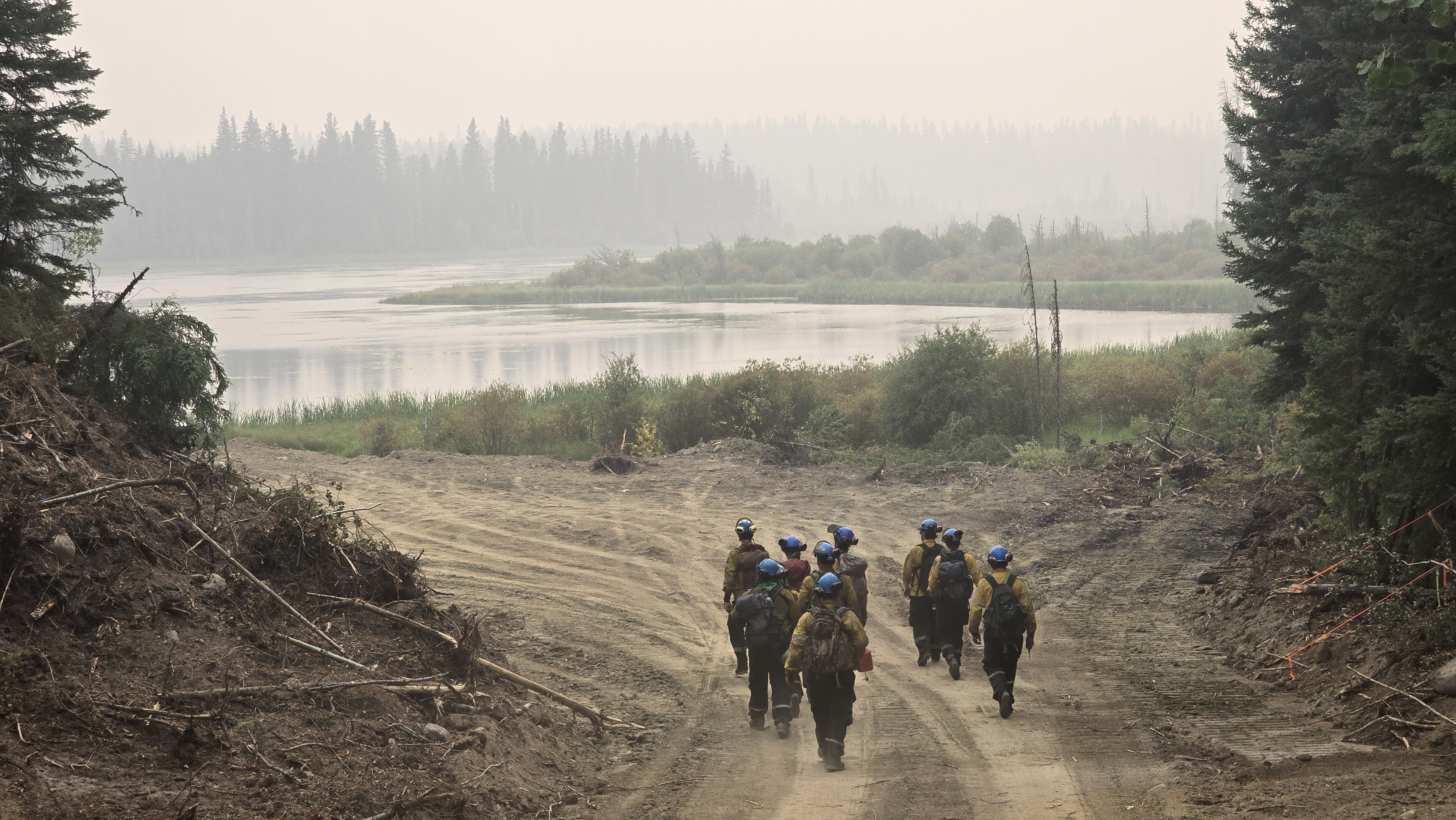
To use regional resources more efficiently, the Saskatchewan Public Safety Agency is now managing the Buhl fire as part of the Weyakwin Complex that includes the Ditch02 and Hawk fires. A Parks Canada Incident Management Team is managing this fire complex on behalf of Saskatchewan, and contributing fire crews, operational staff and helicopters to the operation.
Parks Canada fire crews continue to work directly on the Buhl fire within Prince Albert National Park.
Information bulletins on the Buhl Wildfire are shared on Mondays, Wednesdays and Fridays only, unless there are any significant changes.
Fire Weather
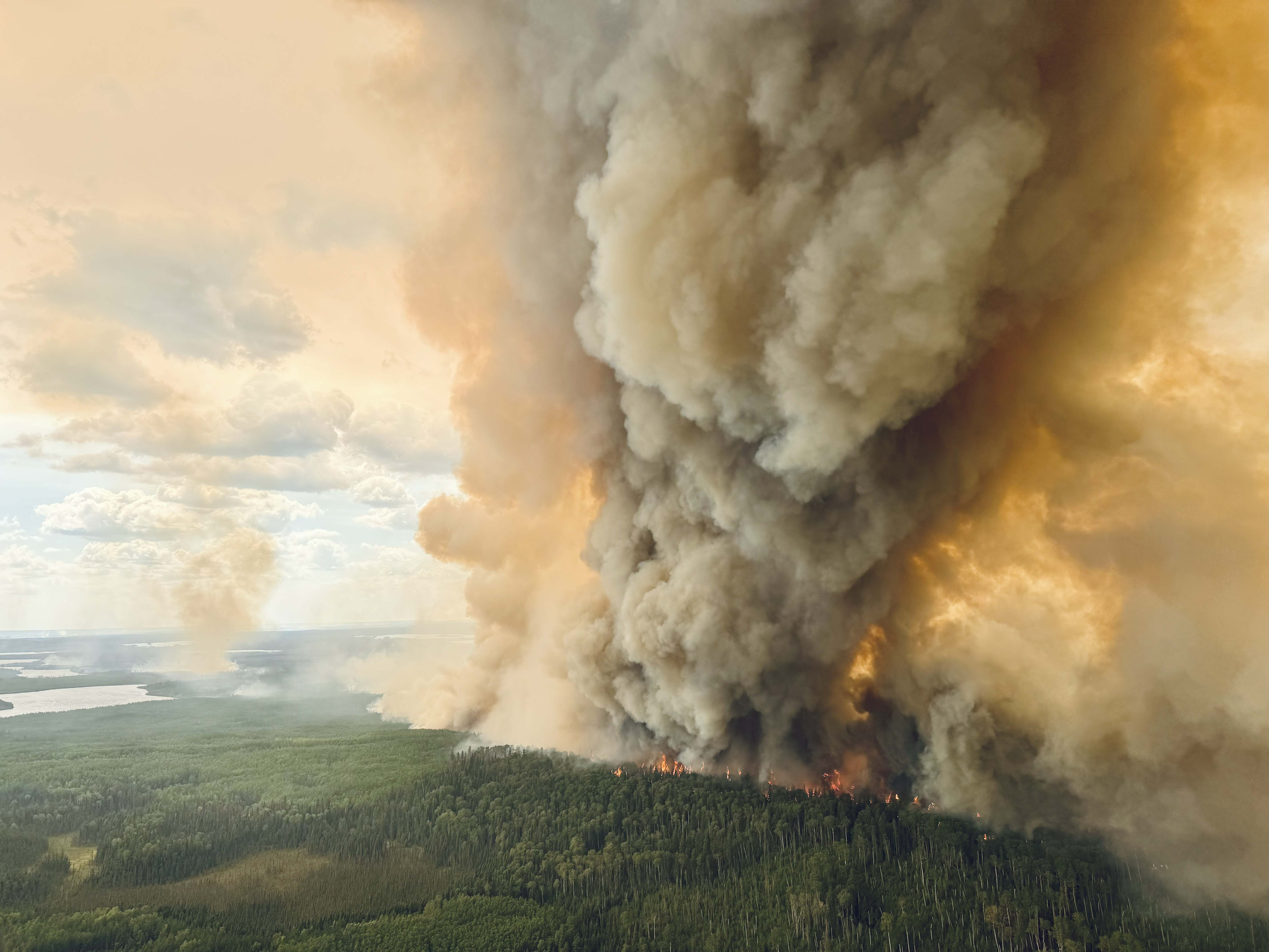
Over the weekend: On Friday, southern parts of the fires received between 15-20 ml of rain helping keep fire behaviour low. Rainfall was more scattered and in lower amounts to the north.
Saturday was overcast while Sunday saw clear, sunny skies in the morning with increased clouds in the afternoon. Temperatures remained in the low to mid-20s (oC). Humidity was relatively high, especially overnight, also helping to minimize fire spread.
While the rain was welcome, fuels could still dry out quickly.
Today: Mix of sun and cloud with a slight chance of scattered showers in the afternoon.
Maximum temperature expected is 22°C and relative humidity will remain high. There may be wind gusts of up to 50 km/hr throughout the day as a cold front moves in from the north.
Fire activity may pick up as things dry out and some areas may see reduced air quality throughout the day with localized smoke.
Fire Summary
Identified: June 29, 2025.
Cause: Lightning
Size: 96,991 hectares
Operations from August 8-10:
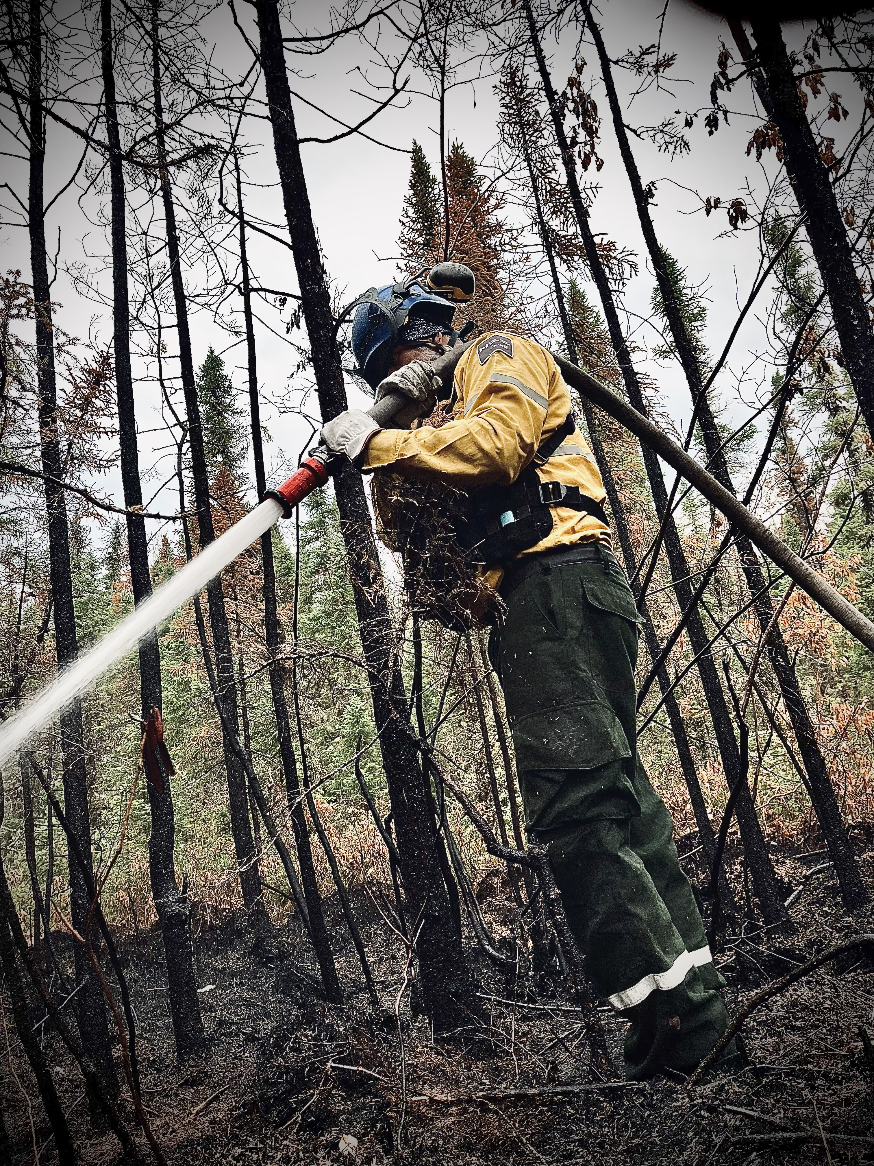
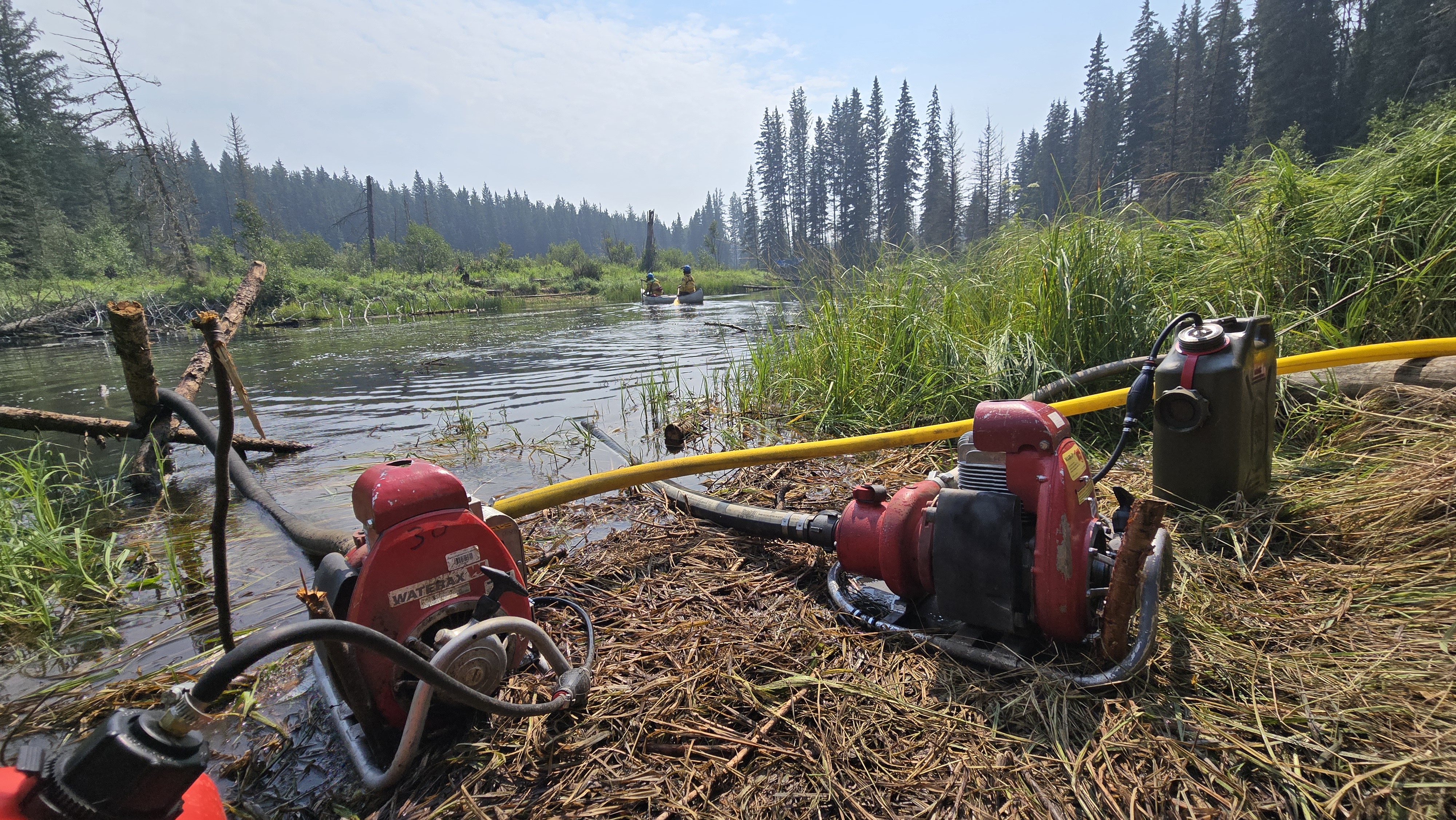
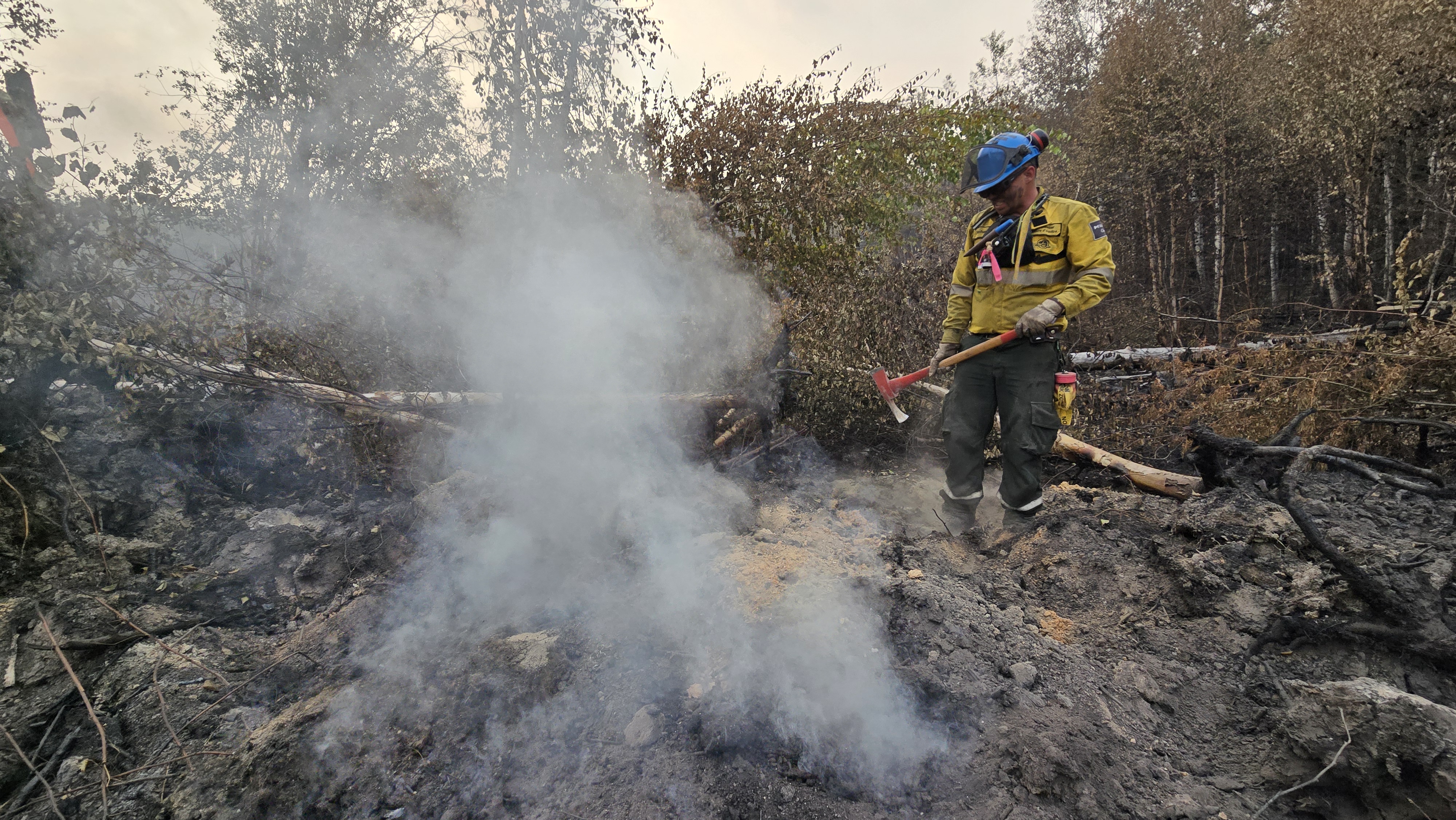
Crews made good progress as they continued working to secure the south and southeast perimeter of the Buhl fire. Hose has been laid along the line to support fire suppression efforts and crews are establishing a 15 metre (50’) blackline. A blackline is created by extinguishing hotspots and burning off remaining forest fuels along the perimeter of the fire. This creates a fuel break to prevent further fire spread. On the west side, crews continued to lay hose line along the fire’s edge between Clarke Lake and Little Clarke Lake.
Current resources assigned to the incident:
- Type 1, 2 and 3 fire crews
- Helicopter and air tanker support
- Heavy equipment
- Out of province incident management personnel and specialists
Community Status Update
For additional information on the current status of communities impacted by the Buhl Fire, refer to the local jurisdiction.
Travelers on Highway 2 north of Waskesiu may see fire activity from the road and visibility may be reduced due to smoke. Drive with caution and check the Highway Hotline for information about road conditions. SPSA fire crews, helicopters, and heavy machinery are working adjacent to the roadway.
Saskatchewan Parks, Culture and Sport, and Northern Municipal Services declared a local emergency and an evacuation order for the Resort Subdivision of Ramsey Bay and Ramsey Bay Campground on July 24, 2025. The evacuation order was terminated on August 10, 2025 at 12:00 PM. For more information, call 1-855-559-5502.
There are no other alerts or orders in effect at this time due to the Buhl Wildfire.
If you see smoke or flames and suspect a wildfire, do not hesitate—call 911 immediately. To report suspicious smoke or wildfires in Prince Albert National Park, call Parks Canada Dispatch at 780-852-3100 (toll free 877-852-3100).
Your quick action can save lives, protect homes, and help emergency responders contain the fire before it spreads.
Additional information
- SK Wildfire Inquiry Line: Available daily from 8 am to 5 pm. Toll-free: 1-855-559-5502
- Daily Buhl Wildfire updates – Prince Albert National Park
- Daily Situation Reports - SK Publications.
- SPSA Interactive Wildfire Map
- FireSmoke Canada
- Prince Albert National Park closures and fire ban
- A fire ban and several area closures in Prince Albert National Park remain in effect while the wildfire response is ongoing. For the safety of yourself and others, please respect all closures and the fire ban.
- Saskatchewan Fire Ban Map
- Saskatchewan Highway Hotline
Buhl Fire Update - August 8
Buhl Fire Information Bulletin – August 8, 2025
Location: Saskatchewan
Fire: Parks Canada – 2025PA04-Buhl, SPSA – 25WY-Buhl
This will be the last daily update on the Buhl Wildfire. Information bulletins will now be shared on Mondays, Wednesdays and Fridays unless there are significant updates.
Size: 95666 hectares (12,740 hectares within Prince Albert National Park, 82,926 hectares on provincial Crown land).*
* Firefighters use multiple tools to measure distances and sizes depending on visibility, smoke and availability of aircraft and drones. These tools have various accuracies to measure distance and are subject to change.
Current as of: August 8, 2025, at 12:00 pm CT.
Please note that the information provided is current at the time of writing and may be subject to change.
Operations from August 7:
A small amount of rain fell across the Buhl fire yesterday helping keep fire behaviour low. Crews continued working toward objectives to secure the fire perimeter. Good progress was made on priority areas in the south and southeast.
Tomorrow, and every day, operations will continue with the same priorities:
- Preserving life and safety.
- Protecting communities, infrastructure, and values at risk.
- Preventing harm to natural and cultural resources.
Incident Command Objective
Parks Canada and the Saskatchewan Public Safety Agency are operating under a Unified Command structure, ensuring a coordinated and collaborative approach to managing the incident and aligning operational objectives, resource sharing, and public communication.
Objectives for managing this incident are ensuring public safety, protecting critical infrastructure, and preserving valued natural and cultural resources. Collaboration between Parks Canada and the Saskatchewan Public Safety Agency allows for a coordinated wildfire response and sharing of timely and accurate information. Control and suppression efforts are aimed at limiting the spread of the wildfire perimeter, primarily in the direction of nearby communities and values at risk. Strategies will include maintaining safe and open access along key highways and roads and safeguarding community structures.
Community Status Update
For additional information on the current status of communities impacted by the Buhl Fire, refer to the local jurisdiction.
Travelers on Highway 2 north of Waskesiu may see fire activity from the road and visibility may be reduced due to smoke. Drive with caution and check the Highway Hotline for information about road conditions. SPSA fire crews, helicopters, and heavy machinery are working adjacent to the roadway.
Saskatchewan Parks, Culture and Sport, and Northern Municipal Services declared a local emergency and an evacuation order for the Resort Subdivision of Ramsey Bay and Ramsey Bay Campground on July 24, 2025. For more information, call 1-855-559-5502.
Prince Albert National Park including the Waskesiu Lake townsite, Montreal Lake Cree Nation, Elk Ridge and McPhee Lake do not currently have any alerts or orders in effect.
If you see smoke or flames and suspect a wildfire, do not hesitate—call 911 immediately. To report suspicious smoke or wildfires in Prince Albert National Park, call Parks Canada Dispatch at 780-852-3100 (toll free 877-852-3100).
Your quick action can save lives, protect homes, and help emergency responders contain the fire before it spreads.
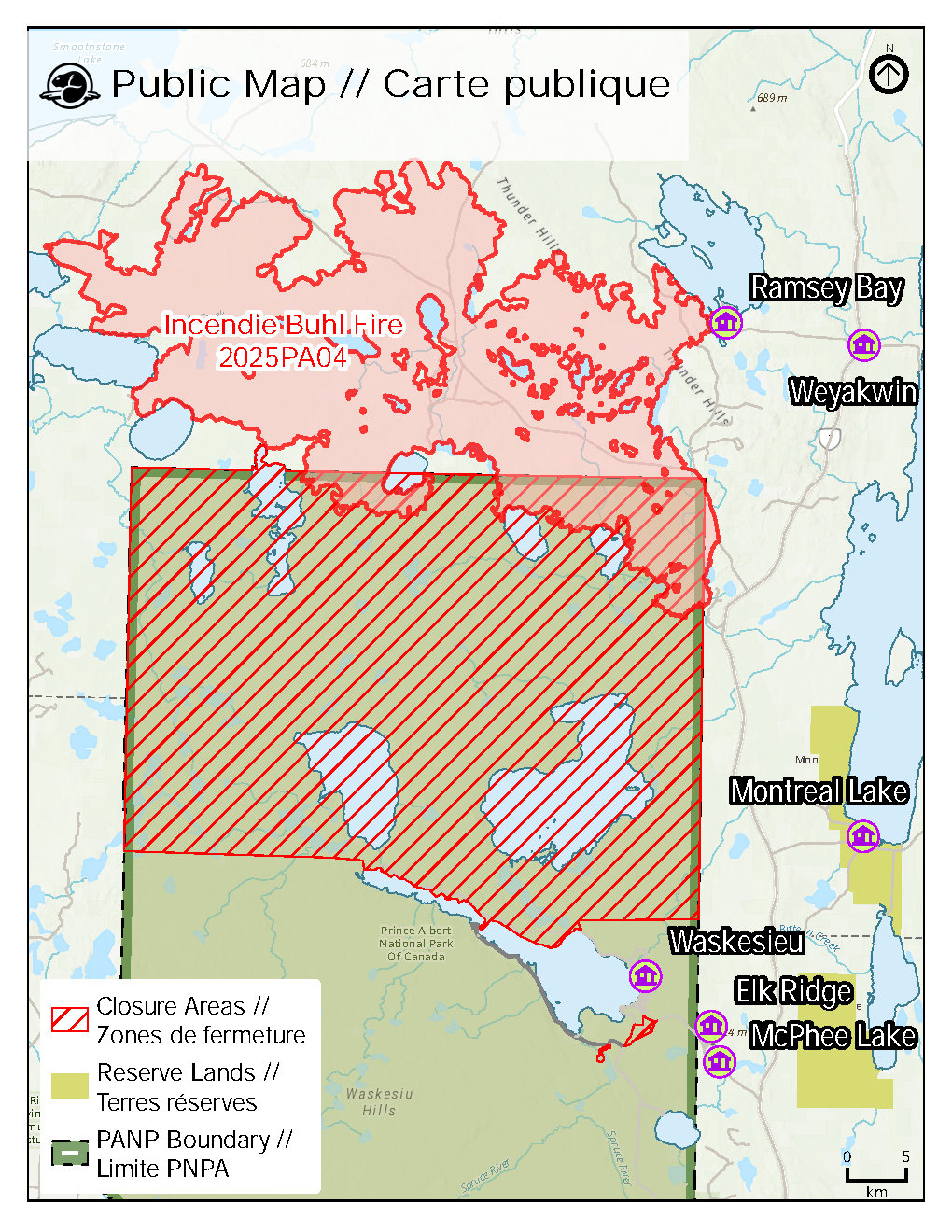
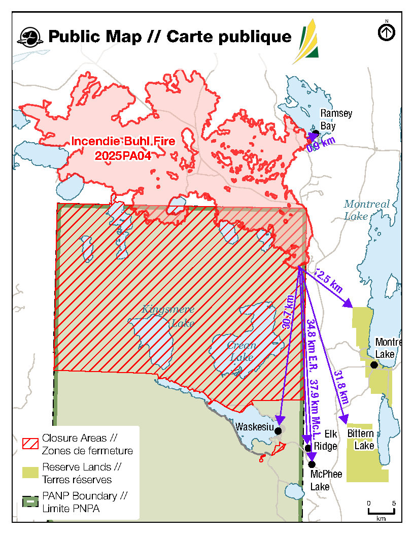
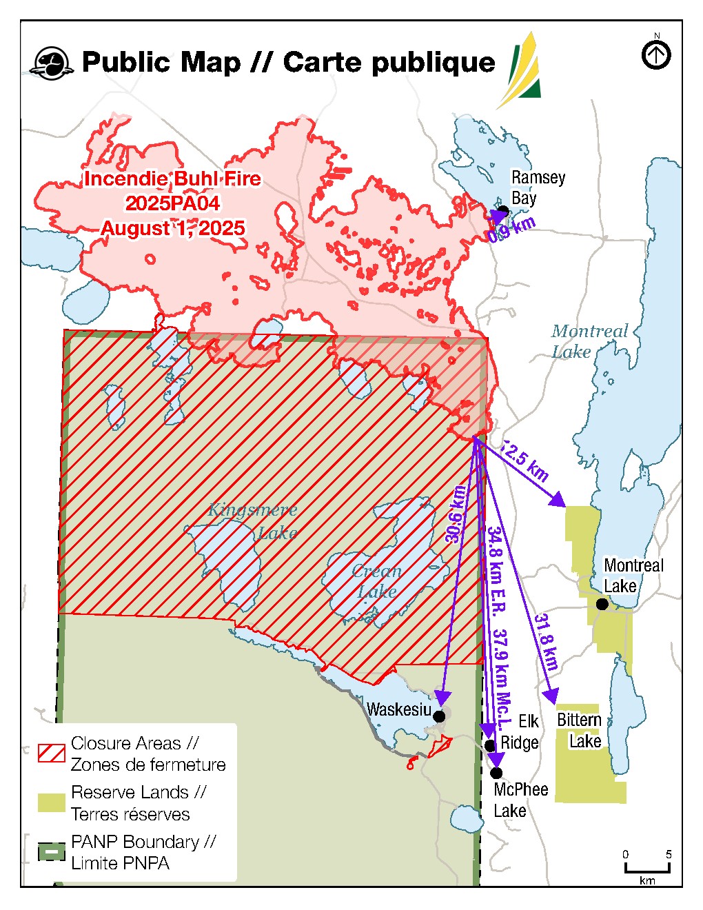
Fire Distance from Communities
Please note these are approximations and not exact distances. This information is only provided as a reference. Continue to monitor and follow instructions provided through the various emergency channels.
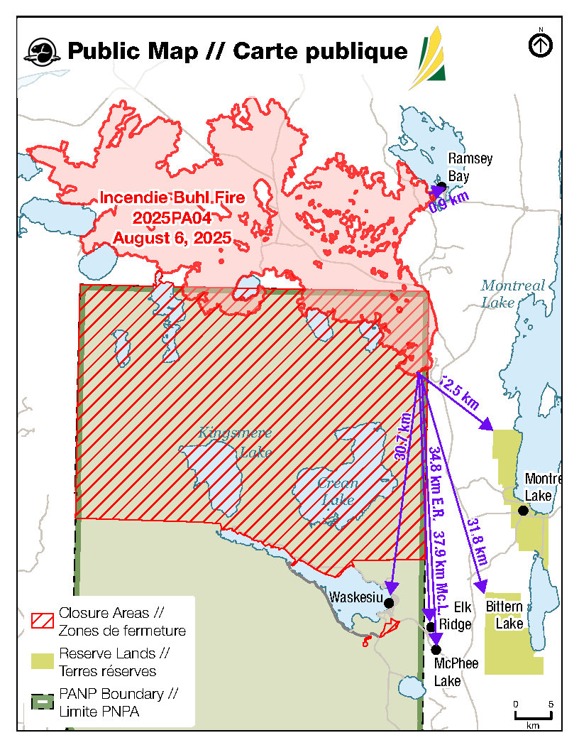
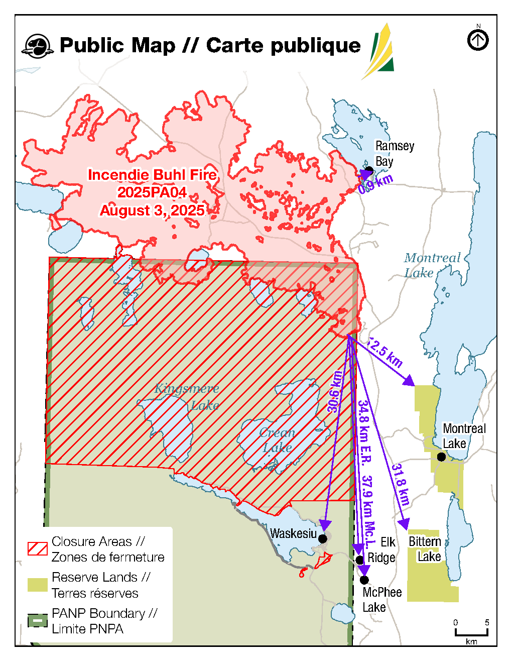
- Ramsey Bay – 0.9 km.
- Montreal Lake – 12.5 km.
- Waskesiu – 30.7 km.
- Bittern Lake – 31.8 km.
- Elk Ridge – 34.8 km.
- McPhee Lake – 37.9 km.
Weather Forecast
Mostly cloudy. Precipitation: 30% chance of showers/thunderstorms in the afternoon.
Maximum temperature: 24°C. Minimum relative humidity: 45%. Winds: E/NE 10-15 km/h, with gusts up to 30 km/h.
Buhl Fire Summary
Identified on June 29, 2025.
Cause: Lightning
Current resources assigned to the incident:
- 153 personnel (not including additional SPSA support staff)
- 6 helicopters
The Buhl Wildfire response also has access to additional air support, including air tankers and water tenders, and heavy equipment as and when required.
Provincial Operation Level: Level 4 - Enhanced Operation, District Response/District EOC activated.
Additional information
- SK Wildfire Inquiry Line: Available daily from 8 am to 5 pm. Toll-free: 1-855-559-5502
- Daily Buhl Wildfire updates – Prince Albert National Park
- Daily Situation Reports - SK Publications.
- SPSA Interactive Wildfire Map
- FireSmoke Canada
- Prince Albert National Park closures and fire ban
- A fire ban and several area closures in Prince Albert National Park remain in effect while the wildfire response is ongoing. For the safety of yourself and others, please respect all closures and the fire ban as the fire danger remains “extreme”.
- Saskatchewan Fire Ban Map
- The SPSA issued a fire ban effective at 8 am on July 10, 2025. The ban remains in effect and encompasses the area north of the provincial forest boundary, up to the Churchill River.
- Saskatchewan Highway Hotline
Buhl Fire Update - August 7

Buhl Fire Information Bulletin – August 7, 2025
Location: Saskatchewan
Fire: Parks Canada – 2025PA04-Buhl, SPSA – 25WY-Buhl
Size: 95,666 hectares (12,740 hectares within Prince Albert National Park, 82,926 hectares on provincial Crown land)*
* Firefighters use multiple tools to measure distances and sizes depending on visibility, smoke and availability of aircraft and drones. These tools have various accuracies to measure distance and are subject to change.
Current as of: August 7, 2025, at 12:30 pm CT.
Please note that the information provided is current at the time of writing and may be subject to change.
Incident Command Objective
Parks Canada and the Saskatchewan Public Safety Agency are operating under a Unified Command structure, ensuring a coordinated and collaborative approach to managing the incident and aligning operational objectives, resource sharing, and public communication.
Objectives for managing this incident are ensuring public safety, protecting critical infrastructure, and preserving valued natural and cultural resources. Collaboration between Parks Canada and the Saskatchewan Public Safety Agency allows for a coordinated wildfire response and sharing of timely and accurate information. Control and suppression efforts are aimed at limiting the spread of the wildfire perimeter, primarily in the direction of nearby communities and values at risk. Strategies will include maintaining safe and open access along key highways and roads and safeguarding community structures.
Operations from August 6:
Scattered showers were received again yesterday, concentrated on the east side of the fire. Minimal fire behaviour was observed in the east as a result of the rain but was more active in the west.
- Continued direct suppression along the southeastern and southern perimeters.
- Used hand tools to dig up hotspots and actioned with water.
- Maintaining structural protection equipment for Ramsey Bay, including a high-volume sprinkler system.
- Demobilizing equipment from areas where the fire line is now contained, allowing resources to be reallocated to higher-priority areas of the fire or to support other fires as needed.
- Ongoing monitoring for future ignition opportunities to support containment efforts.
Tomorrow, and every day, operations will continue with the same priorities:
- Preserving life and safety.
- Protecting communities, infrastructure, and values at risk.
- Preventing harm to natural and cultural resources.
Community Status Update
For additional information on the current status of communities impacted by the Buhl Fire, refer to the local jurisdiction.
Travelers on Highway 2 north of Waskesiu may see fire activity from the road and visibility may be reduced due to smoke. Drive with caution and check the Highway Hotline for information about road conditions. SPSA fire crews, helicopters, and heavy machinery are working adjacent to the roadway.
Saskatchewan Parks, Culture and Sport, and Northern Municipal Services declared a local emergency and an evacuation order for the Resort Subdivision of Ramsey Bay and Ramsey Bay Campground on July 24, 2025. For more information, call 1-855-559-5502.
Prince Albert National Park including the Waskesiu Lake townsite, Montreal Lake Cree Nation, Elk Ridge and McPhee Lake do not currently have any alerts or orders in effect.
If you see smoke or flames and suspect a wildfire, do not hesitate—call 911 immediately. To report suspicious smoke or wildfires in Prince Albert National Park, call Parks Canada Dispatch at 780-852-3100 (toll free 877-852-3100).
Your quick action can save lives, protect homes, and help emergency responders contain the fire before it spreads.
Fire Distance from Communities
Please note these are approximations and not exact distances. This information is only provided as a reference. Continue to monitor and follow instructions provided through the various emergency channels.
- Ramsey Bay – 0.9 km.
- Montreal Lake – 12.5 km.
- Waskesiu – 30.7 km.
- Bittern Lake – 31.8 km.
- Elk Ridge – 34.8 km.
- McPhee Lake – 37.9 km.
Weather Forecast
Partly cloudy. Precipitation: 60% chance of showers/thundershowers in the afternoon.
Maximum temperature: 25°C. Minimum relative humidity: 40%. Winds: SE 10-15 km/h, gusting to 25 km/h.
Buhl Fire Summary
Identified on June 29, 2025.
Cause: Lightning
Current resources assigned to the incident:
- 136 personnel (not including additional SPSA support staff)
- 8 helicopters
The Buhl Wildfire response also has access to additional air support, including air tankers and water tenders, and heavy equipment as and when required.
Provincial Operation Level: Level 4 - Enhanced Operation, District Response/District EOC activated.
Additional information
- SK Wildfire Inquiry Line: Available daily from 8 am to 5 pm. Toll-free: 1-855-559-5502
- Daily Buhl Wildfire updates – Prince Albert National Park
- Daily Situation Reports - SK Publications.
- SPSA Interactive Wildfire Map
- FireSmoke Canada
- Prince Albert National Park closures and fire ban
- A fire ban and several area closures in Prince Albert National Park remain in effect while the wildfire response is ongoing. For the safety of yourself and others, please respect all closures and the fire ban as the fire danger remains “extreme”.
- Saskatchewan Fire Ban Map
- The SPSA issued a fire ban effective at 8 am on July 10, 2025. The ban remains in effect and encompasses the area north of the provincial forest boundary, up to the Churchill River.
- Saskatchewan Highway Hotline
Buhl Fire Update - August 6
Buhl Fire Information Bulletin – August 6, 2025
Location: Saskatchewan
Fire: Parks Canada – 2025PA04-Buhl, SPSA – 25WY-Buhl
Size: 95,449 hectares (13,223 hectares within Prince Albert National Park, 82,226 hectares on provincial Crown land)*
* Firefighters use multiple tools to measure distances and sizes depending on visibility, smoke and availability of aircraft and drones. These tools have various accuracies to measure distance and are subject to change.
Current as of: August 6, 2025, at 12:30 pm CT.
Please note that the information provided is current at the time of writing and may be subject to change.
Incident Command Objective
Parks Canada and the Saskatchewan Public Safety Agency are operating under a Unified Command structure, ensuring a coordinated and collaborative approach to managing the incident and aligning operational objectives, resource sharing, and public communication.
Objectives for managing this incident are ensuring public safety, protecting critical infrastructure, and preserving valued natural and cultural resources. Collaboration between Parks Canada and the Saskatchewan Public Safety Agency allows for a coordinated wildfire response and sharing of timely and accurate information. Control and suppression efforts are aimed at limiting the spread of the wildfire perimeter, primarily in the direction of nearby communities and values at risk. Strategies will include maintaining safe and open access along key highways and roads and safeguarding community structures.
Operations from August 5:
Earlier rainfall helped keep wildfire intensity low, resulting in minimal fire growth. Scattered precipitation was received again in some areas yesterday, primarily on the east side of the wildfire. Yesterday’s operations included:
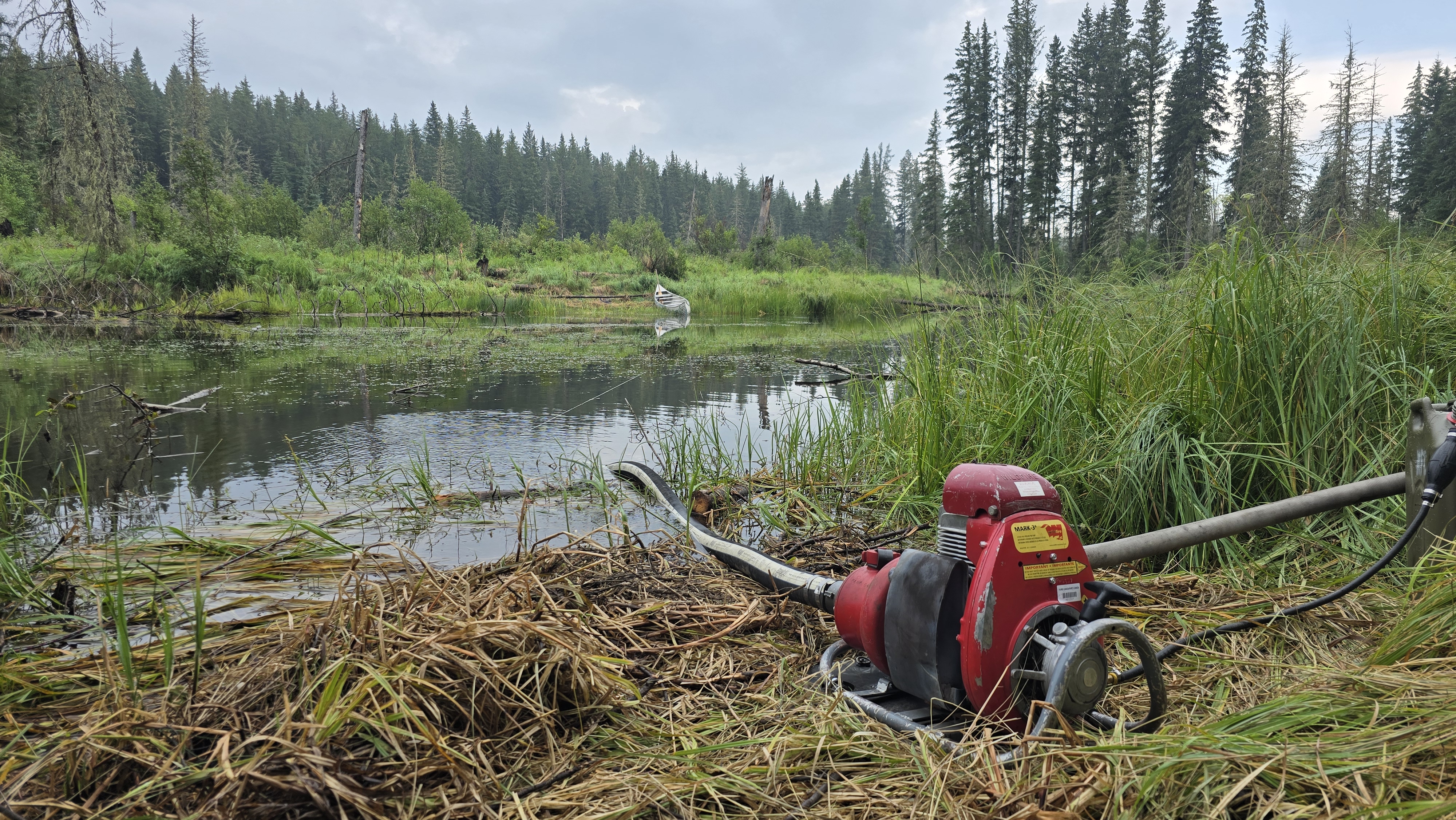
- Continuing to maintain and expand water access to action fire activity along the southeastern perimeter of the wildfire.
- Working to extinguish hotspots in priority areas including near Ramsey Bay, and the northeast corner of Prince Albert National Park.
- Assessing and removing danger trees in key areas of the southeastern and eastern fire perimeter to ensure a safer working environment.
- Continuing direct suppression tactics along the eastern and southeastern fire perimeters and aircraft bucketing in uncontained areas to limit fire spread.
- Maintaining structural protection based on needs for the community of Ramsey Bay, including a high-volume sprinkler system.
Tomorrow, and every day, operations will continue with the same priorities:
- Preserving life and safety.
- Protecting communities, infrastructure, and values at risk.
- Preventing harm to natural and cultural resources.
Community Status Update
For additional information on the current status of communities impacted by the Buhl Fire, refer to the local jurisdiction.
Travelers on Highway 2 north of Waskesiu may see fire activity from the road and visibility may be reduced due to smoke. Drive with caution and check the Highway Hotline for information about road conditions. SPSA fire crews, helicopters, and heavy machinery are working adjacent to the roadway.
Saskatchewan Parks, Culture and Sport, and Northern Municipal Services declared a local emergency and an evacuation order for the Resort Subdivision of Ramsey Bay and Ramsey Bay Campground on July 24, 2025. For more information, call 1-855-559-5502.
Last evening, Parks Canada lifted the pre-evacuation alert for Prince Albert National Park including the Waskesiu Lake townsite. This decision was taken in light of the significant progress towards containment of the Buhl Wildfire within the national park, alongside more favourable weather conditions and a decrease in fire behaviour. Although recent rainfall is welcome, the Buhl Wildfire is still classified as “out of control” and the situation could change quickly. Public safety is a top priority for Parks Canada, and an evacuation alert or order could still be issued if deemed necessary by fire management experts.
Montreal Lake Cree Nation, Elk Ridge and McPhee Lake do not currently have any alerts or orders in effect.
If you see smoke or flames and suspect a wildfire, do not hesitate—call 911 immediately. To report suspicious smoke or wildfires in Prince Albert National Park, call Parks Canada Dispatch at 780-852-3100 (toll free 877-852-3100).
Your quick action can save lives, protect homes, and help emergency responders contain the fire before it spreads.
Fire Distance from Communities
Please note these are approximations and not exact distances. This information is only provided as a reference. Continue to monitor and follow instructions provided through the various emergency channels.
- Ramsey Bay – 0.9 km.
- Montreal Lake – 12.5 km.
- Waskesiu – 30.6 km.
- Bittern Lake – 31.8 km.
- Elk Ridge – 34.8 km.
- McPhee Lake – 37.9 km.
Weather Forecast
Partly cloudy. Precipitation: 30% chance of thundershowers with risk of dry lightning and hail.
Maximum temperature: 24°C. Minimum relative humidity: 35%. Winds: N 10-15 km/h, gusting to 25 km/h.
Buhl Fire Summary
Identified on June 29, 2025.
Cause: Lightning
Current resources assigned to the incident:
- 160 personnel (not including additional SPSA support staff)
- 8 helicopters
The Buhl Wildfire response also has access to additional air support, including air tankers and water tenders, and heavy equipment as and when required.
Provincial Operation Level: Level 4 - Enhanced Operation, District Response/District EOC activated.
Additional information
- SK Wildfire Inquiry Line: Available daily from 8 am to 5 pm. Toll-free: 1-855-559-5502
- Daily Buhl Wildfire updates – Prince Albert National Park
- Daily Situation Reports - SK Publications.
- Prince Albert National Park closures and fire ban: A fire ban and several area closures in Prince Albert National Park remain in effect while the wildfire response is ongoing. For the safety of yourself and others, please respect all closures and the fire ban as the fire danger remains “extreme”.
- Saskatchewan Fire Ban Map: The SPSA issued a fire ban effective at 8 am on July 10, 2025. The ban remains in effect and encompasses the area north of the provincial forest boundary, up to the Churchill River.
Buhl Fire Update - August 5
Buhl Fire Information Bulletin – August 5, 2025
Location: Saskatchewan
Fire: Parks Canada – 2025PA04-Buhl, SPSA – 25WY-Buhl
Size: 95,456 hectares (13,226 hectares within Prince Albert National Park, 82,230 hectares on provincial Crown land)
Current as of: August 5, 2025, at 12:30 pm CT.
Please note that the information provided is current at the time of writing and may be subject to change.
Incident Command Objective
Parks Canada and the Saskatchewan Public Safety Agency are operating under a Unified Command structure, ensuring a coordinated and collaborative approach to managing the incident and aligning operational objectives, resource sharing, and public communication.
Objectives for managing this incident are ensuring public safety, protecting critical infrastructure, and preserving valued natural and cultural resources. Collaboration between Parks Canada and the Saskatchewan Public Safety Agency allows for a coordinated wildfire response and sharing of timely and accurate information. Control and suppression efforts are aimed at limiting the spread of the wildfire perimeter, primarily in the direction of nearby communities and values at risk. Strategies will include maintaining safe and open access along key highways and roads and safeguarding community structures.
Operations from August 4:
The much-needed rain yesterday helped reduce fire intensity in key areas. The northeast section of the fire received varying amounts of precipitation, ranging from 2.5 to 15 mm, while Ramsey Bay received approximately 12 to 15 mm. However, the rainfall was spotty, and some areas received little to no precipitation.
Yesterday, crews:
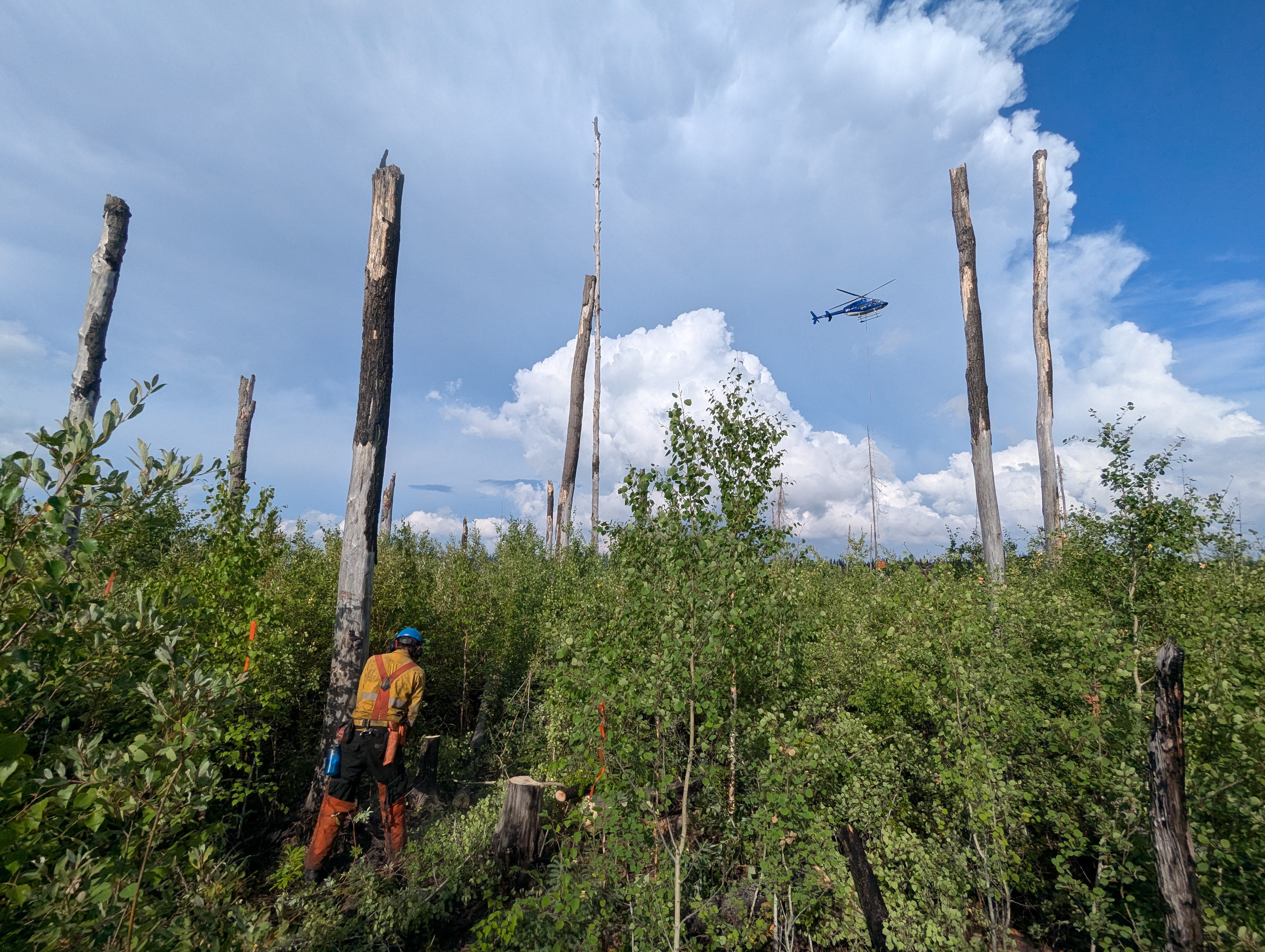
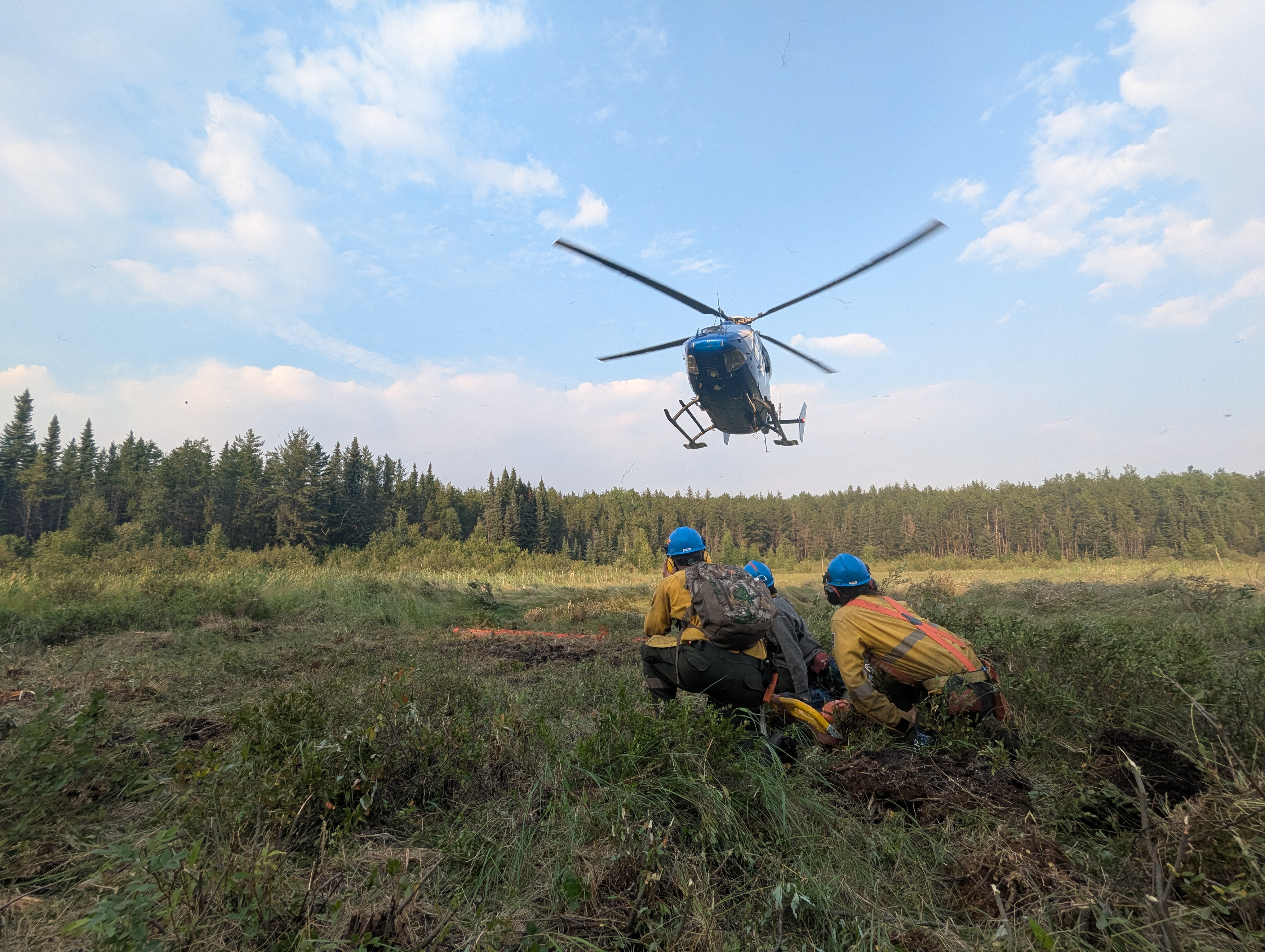
- Improved visibility enabled aerial operations to resume, allowing bucketing and skimmer aircraft to support various locations of the fire.
- Continued direct suppression tactics and extinguished hotspots along the eastern and southeastern fire perimeters, identified by aerial infrared scanning.
- Assessed and removed danger trees in key areas of the southeastern and eastern fire perimeter to ensure a safer working environment.
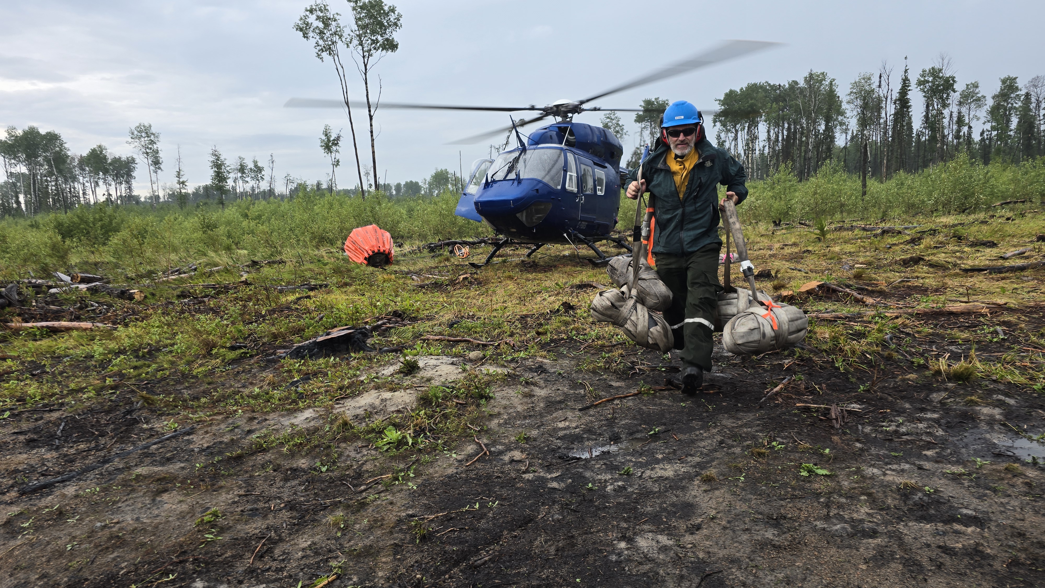
- Completed a new helipad in the southeast, improving access and egress for fire crews.
- Conducted a structural protection exercise in Ramsey Bay to ensure equipment, crews, and volunteer departments were operationally ready. Patrols are ongoing.
Tomorrow, and every day, operations will continue with the same priorities:
- Preserving life and safety.
- Protecting communities, infrastructure, and values at risk.
- Preventing harm to natural and cultural resources.
Community Status Update
For additional information on the current status of communities impacted by the Buhl Fire, refer to the local jurisdiction.
Travelers on Highway 2 north of Waskesiu may see fire activity from the road and visibility may be reduced due to smoke. Drive with caution and check the Highway Hotline for information about road conditions. SPSA fire crews, helicopters, and heavy machinery are working adjacent to the roadway.
Saskatchewan Parks, Culture and Sport, and Northern Municipal Services declared a local emergency and an evacuation order for the Resort Subdivision of Ramsey Bay and Ramsey Bay Campground on July 24, 2025. For more information, call 1-855-559-5502.
Parks Canada reissued the pre-evacuation alert for Prince Albert National Park on August 1, 2025. For more information, see Saskalerts.ca
Montreal Lake Cree Nation, Elk Ridge and McPhee Lake do not currently have any alerts or orders in effect.
If you see smoke or flames and suspect a wildfire, do not hesitate—call 911 immediately. To report suspicious smoke or wildfires in Prince Albert National Park, call Parks Canada Dispatch at 780-852-3100 (toll free 877-852-3100).
Your quick action can save lives, protect homes, and help emergency responders contain the fire before it spreads.
Fire Distance from Communities
Please note these are approximations and not exact distances. This information is only provided as a reference. Continue to monitor and follow instructions provided through the various emergency channels.
- Ramsey Bay – 0.9 km.
- Montreal Lake – 12.5 km.
- Waskesiu – 30.6 km.
- Bittern Lake – 31.8 km.
- Elk Ridge – 34.8 km.
- McPhee Lake – 37.9 km.
Weather Forecast
Cloudy skies. Precipitation: 30% chance of thundershowers with risk of dry lightning and hail.
Maximum temperature: 25°C. Minimum relative humidity: 45%. Winds: SW 12 km/h. Around 12 pm, SE 10 km/h.
Buhl Fire Summary
Identified on June 29, 2025.
Cause: Lightning
Current resources assigned to the incident:
- 161 personnel (not including additional SPSA support staff)
- 11 helicopters
- 1 infrared scanning drone
The Buhl Wildfire response also has access to additional air support, including air tankers and water tenders, and heavy equipment as and when required.
Provincial Operation Level: Level 4 - Enhanced Operation, District Response/District EOC activated.
Additional information
- SK Wildfire Inquiry Line: Available daily from 8 am to 5 pm. Toll-free: 1-855-559-5502
- Daily Buhl Wildfire updates – Prince Albert National Park
- Daily Situation Reports - SK Publications.
- SPSA Interactive Wildfire Map
- FireSmoke Canada
- Prince Albert National Park closures and fire ban
- Saskatchewan Fire Ban Map
- The SPSA issued a fire ban effective at 8 am on July 10, 2025. The ban remains in effect and encompasses the area north of the provincial forest boundary, up to the Churchill River.
- Saskatchewan Highway Hotline
Fire Map: Last Updated – 8 am, August 5, 2025

Buhl Fire Update - August 4
Buhl Fire Information Bulletin – August 4, 2025
Location: Saskatchewan
Fire: Parks Canada – 2025PA04-Buhl, SPSA – 25WY-Buhl
Size: 93,867 hectares (13,210 hectares within Prince Albert National Park, 80,657 hectares on provincial Crown land)
Current as of: August 4, 2025, at 12 pm CT.
Please note that the information provided is current at the time of writing and may be subject to change.
Incident Command Objective
Parks Canada and the Saskatchewan Public Safety Agency are operating under a Unified Command structure, ensuring a coordinated and collaborative approach to managing the incident and aligning operational objectives, resource sharing, and public communication.
Objectives for managing this incident are ensuring public safety, protecting critical infrastructure, and preserving valued natural and cultural resources. Collaboration between Parks Canada and the Saskatchewan Public Safety Agency allows for a coordinated wildfire response and sharing of timely and accurate information. Control and suppression efforts are aimed at limiting the spread of the wildfire perimeter, primarily in the direction of nearby communities and values at risk. Strategies will include maintaining safe and open access along key highways and roads and safeguarding community structures.
Operations from August 3
*Starting today, fire operations updates will only include completed work from the previous day, as most efforts remain ongoing.
Yesterday, low-lying smoke and fog helped keep the fire intensity lower but also grounded aerial operations. Crews were still able to make meaningful progress where possible:
- Used dozers to complete work along an existing guard and contingency line near the northeast perimeter, to limit fire spread.
- Continued direct suppression tactics along the eastern and southeastern fire perimeters and extinguishing hotspots along Highway 916.
- Ongoing structural protection operations for Ramsey Bay continued with additional crews and volunteer fire departments on-site.
- Ran the high-volume sprinkler system to dampen the fuel break.
- Removed hazardous trees along the Ramsey Bay high-volume sprinkler hose line to prevent damage or interruption to the system.
Due to unsafe flying conditions, crews assigned to divisions only accessible by air were redeployed to other areas and fire line operations.
Tomorrow, and every day, operations will continue with the same priorities:
- Preserving life and safety.
- Protecting communities, infrastructure, and values at risk.
- Preventing harm to natural and cultural resources.
Community Status Update
For additional information on the current status of communities impacted by the Buhl Fire, refer to the local jurisdiction.
Travelers on Highway 2 north of Waskesiu may see fire activity from the road and visibility may be reduced due to smoke from the Ditch Fire. Drive with caution and check the Highway Hotline for information about road conditions. SPSA fire crews, helicopters, and heavy machinery are working adjacent to the roadway on the Ditch Fire.
Saskatchewan Parks, Culture and Sport, and Northern Municipal Services declared a local emergency and an evacuation order for the Resort Subdivision of Ramsey Bay and Ramsey Bay Campground on July 24, 2025. For more information, call 1-855-559-5502.
Parks Canada reissued the pre-evacuation alert for Prince Albert National Park on August 1, 2025. For more information, see Saskalerts.ca
Montreal Lake Cree Nation, Elk Ridge and McPhee Lake do not currently have any alerts or orders in effect.
If you see smoke or flames and suspect a wildfire, do not hesitate—call 911 immediately. To report suspicious smoke or wildfires in Prince Albert National Park, call Parks Canada Dispatch at 780-852-3100 (toll free 877-852-3100).
Your quick action can save lives, protect homes, and help emergency responders contain the fire before it spreads.
Fire Distance from Communities
Please note these are approximations and not exact distances. This information is only provided as a reference. Continue to monitor and follow instructions provided through the various emergency channels.
- Ramsey Bay – 0.9 km.
- Montreal Lake – 12.5 km.
- Waskesiu – 30.6 km.
- Bittern Lake – 31.8 km.
- Elk Ridge – 34.8 km.
- McPhee Lake – 37.9 km.
Weather Forecast
Partly cloudy. Precipitation: 30% chance of thundershowers with risk of dry lightning and hail.
Maximum temperature: 28°C. Minimum relative humidity: 40%. Winds: SE 25 km/h with gusts up to 50 km/h. Around 12 pm, S/SW 25km/h with gusts up to 50%.
Buhl Fire Summary
Identified on June 29, 2025.
Cause: Lightning
Current resources assigned to the incident:
- 227 personnel (not including additional SPSA support staff)
- 12 helicopters
- 1 infrared scanning drone
- 11 pieces of heavy equipment.
The Buhl Wildfire response also has access to additional air support as and when required, including air tankers and water tenders.
Provincial Operation Level: Level 4 - Enhanced Operation, District Response/District EOC activated.
Additional information
- SK Wildfire Inquiry Line: Available daily from 8 am to 5 pm. Toll-free: 1-855-559-5502
- Daily Buhl Wildfire updates – Prince Albert National Park
- Daily Situation Reports - SK Publications.
- SPSA Interactive Wildfire Map
- FireSmoke Canada
- Prince Albert National Park closures and fire ban
- Saskatchewan Fire Ban Map
- The SPSA issued a fire ban effective at 8 am on July 10, 2025. The ban remains in effect and encompasses the area north of the provincial forest boundary, up to the Churchill River.
- Saskatchewan Highway Hotline
Fire Map: Last Updated – 9 am, August 4, 2025

Buhl Fire Update - August 3
Buhl Fire Information Bulletin – August 3, 2025
Location: Saskatchewan
Fire: Parks Canada – 2025PA04-Buhl, SPSA – 25WY-Buhl
Size: 93,867 hectares (13,210 hectares within Prince Albert National Park, 80,657 hectares on provincial Crown land)
Current as of: August 3, 2025, at 13 pm CT.
Please note that the information provided is current at the time of writing and may be subject to change.
Incident Command Objective
Parks Canada and the Saskatchewan Public Safety Agency are operating under a Unified Command structure, ensuring a coordinated and collaborative approach to managing the incident and aligning operational objectives, resource sharing, and public communication.
Objectives for managing this incident are ensuring public safety, protecting critical infrastructure, and preserving valued natural and cultural resources. Collaboration between Parks Canada and the Saskatchewan Public Safety Agency allows for a coordinated wildfire response and sharing of timely and accurate information. Control and suppression efforts are aimed at limiting the spread of the wildfire perimeter, primarily in the direction of nearby communities and values at risk. Strategies will include maintaining safe and open access along key highways and roads and safeguarding community structures.
Operations from August 2
*Starting August 4, fire operations updates will only include completed work from the previous day, as most efforts remain ongoing.
Fire activity continues to be challenging this week due to smoke and the ongoing warm, dry and windy conditions. Parks Canada, Saskatchewan Public Safety Agency and the several other supporting agencies from across the country are working together on the Buhl Fire response.
- Continued direct suppression along eastern fire perimeter and Highway 916, to strengthen containment and limit further spread.
- Utilized heavy equipment to widen an existing guard and create a contingency line in the northeast perimeter near Ramsey Bay.
- Continued suppression tactics to work towards containing the northeast fire perimeter by Weyakwin Lake, supported by aerial resources.
- Structural protection operations were maintained for Ramsey Bay with additional crews and volunteer fire departments patrolling on-site. In addition to activating sprinklers, crews secured flammables and wetted roofs in the community.
Today’s Focus: The following is the current operational plan for fire crews across the incident zone. Due to the dynamic nature of wildfire response, crews and equipment may be reassigned at any time. This information reflects intentions, not guarantees.
Priorities for Operations for August 2
- Using controlled ignition, bring the fire perimeter to natural or constructed features around Tibiska and Cheeyas lakes to reinforce barriers to fire spread.
- Use dozers to continue work along the existing guard and contingency line near the northeast perimeter to limit spread.
- Continue direct suppression tactics along the eastern and southeastern fire perimeters, with bucketing support.
- Ongoing structural protection operations for Ramsey Bay with additional crews and volunteer fire departments on-site.
Depending on the circumstances, controlled ignitions can be one of the most effective tools available during wildfire responses. Planned ignitions are carried out to remove vegetation from the path of a fire to slow or halt its growth. These fuel removal operations can range from small-scale hand ignitions to large-scale aerial ignitions and are only carried out under very specific conditions.
Community Status Update
For additional information on the current status of communities impacted by the Buhl Fire, refer to the local jurisdiction.
Travelers on Highway 2 north of Waskesiu may see fire activity from the road and visibility may be reduced due to smoke from the Ditch Fire. Drive with caution and check the Highway Hotline for information about road conditions. SPSA fire crews, helicopters, and heavy machinery are working adjacent to the roadway on the Ditch Fire.
Saskatchewan Parks, Culture and Sport, and Northern Municipal Services declared a local emergency and an evacuation order for the Resort Subdivision of Ramsey Bay and Ramsey Bay Campground on July 24, 2025. For more information, call 1-855-559-5502.
Parks Canada reissued the pre-evacuation alert for Prince Albert National Park on August 1, 2025. For more information, see Saskalerts.ca
Montreal Lake Cree Nation, Elk Ridge and McPhee Lake do not currently have any alerts or orders in effect.
If you see smoke or flames and suspect a wildfire, do not hesitate—call 911 immediately. To report suspicious smoke or wildfires in Prince Albert National Park, call Parks Canada Dispatch at 780-852-3100 (toll free 877-852-3100).
Your quick action can save lives, protect homes, and help emergency responders contain the fire before it spreads.
Fire Distance from Communities
Please note these are approximations and not exact distances. This information is only provided as a reference. Continue to monitor and follow instructions provided through the various emergency channels.
- Ramsey Bay – 0.9 km.
- Montreal Lake – 12.5 km.
- Waskesiu – 30.6 km.
- Bittern Lake – 31.8 km.
- Elk Ridge – 34.8 km.
- McPhee Lake – 37.9 km.
Weather Forecast
Partly cloudy.
Maximum temperature: 32°C. Minimum relative humidity: 30%. Winds: SE 10-15 km/h with gusts up to 30 km/h. Precipitation: 30% chance of thundershowers with risk of dry lightning and hail.
Buhl Fire Summary
Identified on June 29, 2025.
Cause: Lightning
Current resources assigned to the incident:
- 227 personnel (not including additional SPSA support staff)
- 12 helicopters
- 1 infrared scanning drone
- 11 pieces of heavy equipment.
The Buhl Wildfire response also has access to additional air support as and when required, including air tankers and water tenders.
Provincial Operation Level: Level 4 - Enhanced Operation, District Response/District EOC activated.
Additional information
- SK Wildfire Inquiry Line: Available daily from 8 am to 5 pm. Toll-free: 1-855-559-5502
- Daily Buhl Wildfire updates – Prince Albert National Park
- Daily Situation Reports - SK Publications.
- SPSA Interactive Wildfire Map
- FireSmoke Canada
- Prince Albert National Park closures and fire ban
- Saskatchewan Fire Ban Map
- The SPSA issued a fire ban effective at 8 am on July 10, 2025. The ban remains in effect and encompasses the area north of the provincial forest boundary, up to the Churchill River.
- Saskatchewan Highway Hotline
Fire Map: Last Updated – 8:00 am, August 3, 2025
Buhl Fire Update - August 2
Buhl Fire Information Bulletin – August 2, 2025
Location: Saskatchewan
Fire: Parks Canada – 2025PA04-Buhl, SPSA – 25WY-Buhl
Current as of: August 2, 2025, at 13 pm CT.
Please note that the information provided is current at the time of writing and may be subject to change.
Fire activity continues to be challenging this week due to smoke and the ongoing warm, dry and windy conditions. Parks Canada, Saskatchewan Public Safety Agency and the several other supporting agencies from across the country are working together on the Buhl Wildfire response.
Travelers on Highway 2 north of Waskesiu may see fire activity from the road and visibility may be reduced due to smoke from the Ditch Fire. Drive with caution and check the Highway Hotline for the most up to date information on road conditions. SPSA fire crews, helicopters, and heavy machinery are working adjacent to the roadway on the Ditch Fire.
Community Status Update
For additional information on the current status of communities impacted by the Buhl Fire, refer to the local jurisdiction.
Saskatchewan Parks, Culture and Sport, and Northern Municipal Services declared a local emergency and an evacuation order for the Resort Subdivision of Ramsey Bay and Ramsey Bay Campground on July 24, 2025. All residents are required to evacuate as soon as possible. For more information, call 1-855-559-5502.
Parks Canada reissued a pre-evacuation alert for Prince Albert National Park on August 1, 2025, due to the Buhl Wildfire that has potential to cause emergency situations for the public, including deteriorating air quality and or visibility due to wildfire smoke. For more information, see Saskalerts.ca
Montreal Lake Cree Nation, Elk Ridge and McPhee Lake do not currently have any alerts or orders in effect.
Closures and Fire Ban
The fire ban and several area closures in Prince Albert National Park remain in effect. Violating an area closure has serious consequences and may put your safety or others at risk. For more information on area closures and the fire ban, see the Important Bulletins page of the Prince Albert National Park website.
The Saskatchewan Public Safety Agency issued a fire ban effective at 8 am on July 10, 2025, due to high fire activity and extreme fire risk. The ban remains in effect and encompasses the area north of the provincial forest boundary, up to the Churchill River.
Buhl Fire Summary
The Buhl Fire, first identified on June 29, 2025, was caused by a lightning strike and has burned approximately 90,104 hectares – 12,893 hectares within park boundaries and 77,210 hectares on provincial Crown land. Current resources assigned to the incident include 227 personnel (not including additional SPSA support staff), 12 helicopters, 1 infrared scanning drone and 11 pieces of heavy equipment. The Buhl Wildfire response also has access to additional air support as and when required, including air tankers and water tenders.
Provincial Operation Level: Level 4 - Enhanced Operation, District Response/District EOC activated.
Fire Distance from Communities
Please note these are approximations and not exact distances. This information is only provided as a reference. Continue to monitor and follow instructions provided through the various emergency channels.
- Ramsey Bay – 0.9 km. *Changes in distance are attributed to enhanced mapping and wildfire perimeter data.
- Montreal Lake – 12.5 km.
- Waskesiu – 30.6 km.
- Bittern Lake – 31.8 km.
- Elk Ridge – 34.8 km.
- McPhee Lake – 37.9 km.
Weather Forecast
Fair overnight recovery expected. Surface inversion expected to break by 9:00 am, or when surface temperatures reach 26°C. Partly cloudy with crossover conditions.
Maximum temperature: 32°C. Minimum relative humidity: 30%. Winds: S 5-15 km/h with gusts up to 25 km/h. Precipitation: 30% chance of thundershowers with possible dry lightning and small hail.
Incident Command Objective
Parks Canada and the Saskatchewan Public Safety Agency are operating under a Unified Command structure, ensuring a coordinated and collaborative approach to managing the incident and aligning operational objectives, resource sharing, and public communication.
Objectives for managing this incident are ensuring public safety, protecting critical infrastructure, and preserving valued natural and cultural resources. Collaboration between Parks Canada and the Saskatchewan Public Safety Agency allows for a coordinated wildfire response and sharing of timely and accurate information. Control and suppression efforts are aimed at limiting the spread of the wildfire perimeter, primarily in the direction of nearby communities and values at risk. Strategies will include maintaining safe and open access along key highways and roads and safeguarding community structures.
Operations from August 1
Continued direct suppression along the northeastern, eastern and southeastern fire perimeters, supported by aerial resources, including bucketing and air tanker where possible.
- Extinguished hotspots along eastern perimeter and Highway 916 to strengthen containment line and limit spread to the south or east.
- Maintained comprehensive structural protection operations for Ramsey Bay including the setup of a high-volume sprinkler system, with additional crews and volunteer fire departments on-site to patrol.
Today’s Focus: The following is the current operational plan for fire crews across the incident zone. Due to the dynamic nature of wildfire response, crews and equipment may be reassigned at any time. This information reflects intentions, not guarantees.
Priorities for Operations for August 2
- Continue direct suppression along eastern fire perimeter and Highway 916, to strengthen containment and limit further spread, supported by aerial resources, as needed.
- Utilize heavy equipment and direct suppression tactics to work towards containing the northeast fire perimeter by Weyakwin Lake, supported by aerial resources.
- Continue structural protection operations for Ramsey Bay with additional crews and volunteer fire departments on-site to patrol.
- Continue direct suppression on southeast perimeter to prevent southernly spread.
Depending on the circumstances, controlled ignitions can be one of the most effective tools available during wildfire responses. Planned ignitions are carried out to remove vegetation from the path of a fire to slow or halt its growth. These fuel removal operations can range from small-scale hand ignitions to large-scale aerial ignitions and are only carried out under very specific conditions.
If you see smoke or flames and suspect a wildfire, do not hesitate—call 911 immediately. To report suspicious smoke or wildfires in Prince Albert National Park, call Parks Canada Dispatch at 780-852-3100 (toll free 877-852-3100) or Prince Albert National Park at 306-663-4522.
Your quick action can save lives, protect homes, and help emergency responders contain the fire before it spreads.
SK Wildfire Inquiry Line
Available daily from 8 am to 5 pm. Toll-free: 1-855-559-5502
Situation Reports are posted daily and can be found on the SK Publications Website and on the Prince Albert National Park website.
Visual information is located on the SPSA Interactive Wildfire Map.
For more information regarding wildfire weather and smoke, please visit FireSmoke Canada.
To learn more about highway conditions, including closures, please visit SK Highway Hotline.
Fire Map: Last Updated – 10 am, August 2, 2025
Buhl Fire Update - August 1
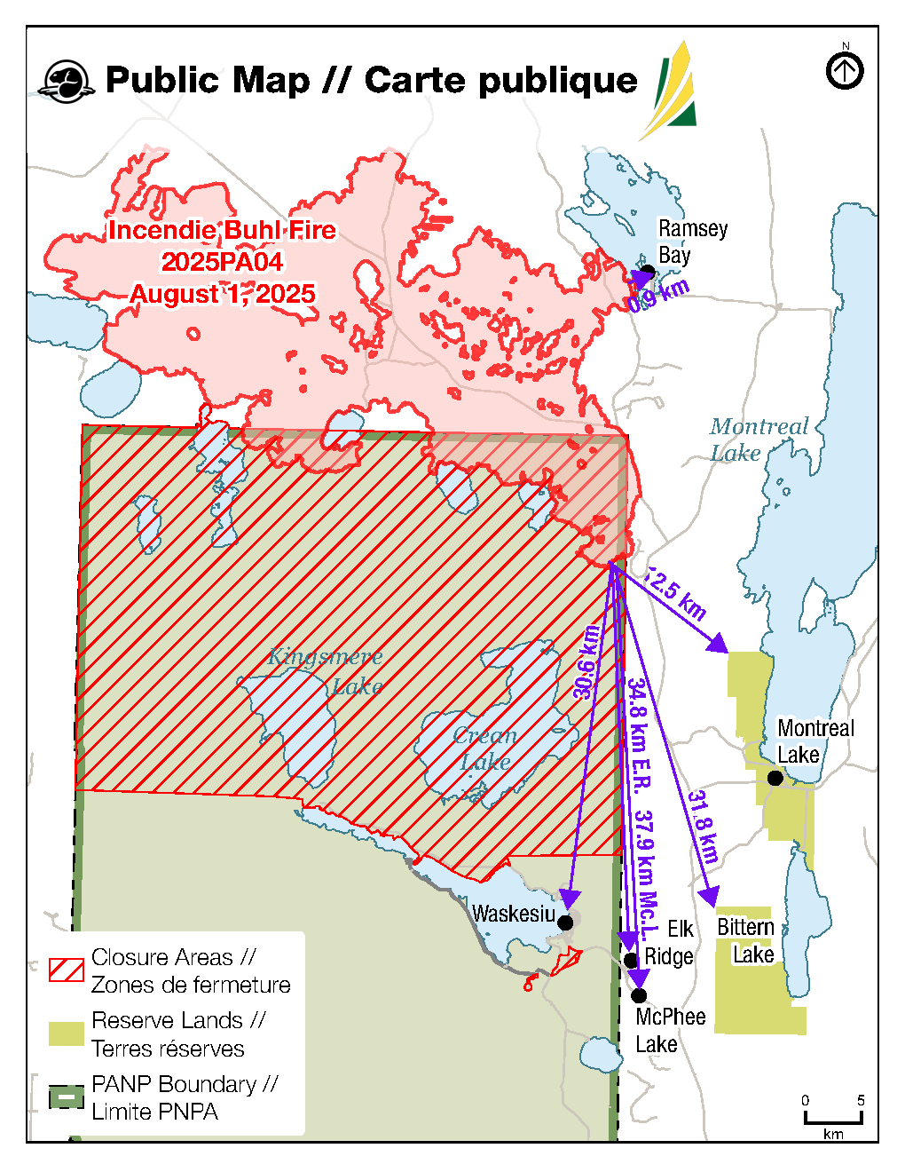
Buhl Fire Information Bulletin – August 1, 2025
Location: Saskatchewan
Fire: Parks Canada – 2025PA04-Buhl, SPSA – 25WY-Buhl
Current as of: August 1, 2025, at 12 pm CT.
Please note that the information provided is current at the time of writing and may be subject to change.
Use of drones is illegal in Prince Albert National Park. Flying drones near a wildfire zone results in grounding of incident helicopter operations used in wildfire suppression or emergencies. There are serious safety and legal implications for failing to comply.
There is an airspace restriction in place for the Buhl Fire area. Overflights are strongly discouraged as they interfere with safe incident air operations and must not interfere with the Notice to Airmen (NOTAM –Canadian Aircraft Regulation 601.15(a)).
Community Status Update
For additional information on the current status of communities impacted by the Buhl Fire, refer to the local jurisdiction.
Saskatchewan Parks, Culture and Sport, and Northern Municipal Services declared a local emergency and an evacuation order for the Resort Subdivision of Ramsey Bay and Ramsey Bay Campground on July 24, 2025. All residents are required to evacuate as soon as possible. For more information, call 1-855-559-5502.
As of July 30, 2025, residents of Montreal Lake Cree Nation are repatriating. The evacuation order has been removed.
Parks Canada reissued a pre-evacuation alert for Prince Albert National Park on July 26, 2025, due to the Buhl Wildfire that has potential to cause emergency situations for the public, including deteriorating air quality and or visibility due to wildfire smoke. For more information, see Saskalert.ca
Elk Ridge and McPhee Lake do not currently have any alerts or orders in effect.
SaskAlert Registration Update
For users having trouble finding these locations in the SaskAlert mobile apps, please use the below correlated postal code in the app’s search bar.
Apple iOS Devices (Apple Maps):
• Waskesiu – use postal code S0J 2Y0
• McPhee Lake – use postal code S0J 2Y0
• Elk Ridge – use postal code S0J 2Y0
Google/Android Devices (Google Maps):
• Waskesiu – use postal code S0J 2Y0
• McPhee Lake – use Elk Ridge
• Elk Ridge – use Elk Ridge
The experience with SaskAlert can vary depending on the mobile device and the map app they use. We’re continuing to work with both Apple and Google Maps to improve this.
Closures and Fire Ban
Prince Albert National Park has area closures in effect for the northern area of the park, Overflow Campground area and the Beartrap Helipad. Violating an area closure has serious consequences and may put your safety or others at risk. There is also a fire ban in effect. For more information on area closures and the fire ban, see the Important Bulletins page of the Prince Albert National Park website.
In addition, the Saskatchewan Public Safety Agency issued a fire ban effective at 8 am on July 10, 2025, due to high fire activity and extreme fire risk. The ban encompasses the area north of the provincial forest boundary, up to the Churchill River.
Buhl Fire Summary
The Buhl Fire, first identified on June 29, 2025, was caused by a lightning strike and has burned approximately 86,806 hectares – 12,692 hectares within park boundaries and 74,114 hectares on provincial Crown land. Current resources assigned to the incident include 225 personnel (not including additional SPSA support staff), 12 helicopters, one infrared scanning drone and 11 pieces of heavy equipment. The Buhl Wildfire response also has access to additional air support as and when required, including air tankers and water tenders.
Fire activity has been increasingly challenging this week due to smoke and the warm, dry and windy conditions. Parks Canada, SPSA and the several other supporting agencies from across the country are working together on the Buhl Fire response.
Provincial Operation Level: Level 4 - Enhanced Operation, District Response/District EOC activated.
Fire Distance from Communities
Please note these are approximations and not exact distances. This information is only provided as a reference. Continue to monitor and follow instructions provided through the various emergency channels.
• Ramsey Bay – 0.9 km. *Changes in distance are attributed to enhanced mapping and wildfire perimeter data.
• Montreal Lake – 12.5 km.
• Waskesiu – 30.6 km.
• Bittern Lake – 31.8 km.
• Elk Ridge – 34.8 km.
• McPhee Lake – 37.9 km.
Weather Forecast
Poor overnight recovery expected. Surface inversion expected to break by 9:00 am. Sunny, crossover conditions.
Maximum temperature: 31°C. Minimum relative humidity: 25%. Winds: S/SE 5-15 km/h with gusts up to 25 km/h. Precipitation: Nil.
Incident Command Objective
Parks Canada and the Saskatchewan Public Safety Agency are operating under a Unified Command structure, ensuring a coordinated and collaborative approach to managing the incident and aligning operational objectives, resource sharing, and public communication.
Objectives for managing this incident are ensuring public safety, protecting critical infrastructure, and preserving valued natural and cultural resources. Collaboration between Parks Canada and the Saskatchewan Public Safety Agency allows for a coordinated wildfire response and sharing of timely and accurate information. Control and suppression efforts are aimed at limiting the spread of the wildfire perimeter, primarily in the direction of nearby communities and values at risk. Strategies will include maintaining safe and open access along key highways and roads and safeguarding community structures.
Operations from July 31
• Used heavy equipment and direct suppression to work towards containing the northeast fire perimeter by Weyakwin Lake, supported by aerial resources.
• Continued to extinguish hotspots along eastern perimeter and Highway 916 to strengthen containment line and limit spread south or east.
• Continued direct suppression efforts and controlled ignition, where feasible, along southeastern and eastern perimeter to work towards containment.
• Continued structural protection operations for Ramsey Bay including the installation of a high-volume sprinkler system with additional crews and volunteer fire departments on-site to patrol.
Today’s Focus: The following is the current operational plan for fire crews across the incident zone. Due to the dynamic nature of wildfire response, crews and equipment may be reassigned at any time. This information reflects intentions, not guarantees.
Priorities for Operations for August 1
• Continue heavy equipment and direct suppression towards containment to the northeast fire perimeter by Weyakwin Lake, supported by aerial resources, as needed.
• Use direct suppression and aerial resources to limit spread to the east, between Cheeyas Lake and the unnamed lake to the north.
• Continue to extinguish hotspots along eastern perimeter and Highway 916 to strengthen containment line and limit spread south or east.
• Continue direct suppression efforts along southeastern and eastern perimeter to work towards containment.
• Continue structural protection operations for Ramsey Bay including the installation of a high-volume sprinkler system with additional crews and volunteer fire departments on-site to patrol.
Depending on the circumstances, controlled ignitions can be one of the most effective tools available during wildfire responses. Planned ignitions are carried out to remove vegetation from the path of a fire to slow or halt its growth. These fuel removal operations can range from small-scale hand ignitions to large-scale aerial ignitions and are only carried out under very specific conditions.
If you see smoke or flames and suspect a wildfire, do not hesitate—call 911 immediately. To report suspicious smoke or wildfires in Prince Albert National Park, call Parks Canada Dispatch at 780-852-3100 (toll free 877-852-3100) or Prince Albert National Park at 306-663-4522.
Your quick action can save lives, protect homes, and help emergency responders contain the fire before it spreads.
SK Wildfire Inquiry Line
Available daily from 8 am to 5 pm. Toll-free: 1-855-559-5502
Situation Reports are posted daily and can be found on the SK Publications Website and on the Prince Albert National Park website.
Visual information is located on the SPSA Interactive Wildfire Map.
For more information regarding wildfire weather and smoke, please visit FireSmoke Canada.
To learn more about highway conditions, including closures, please visit SK Highway Hotline.
Buhl Fire Update - July 31
Buhl Fire Information Bulletin – July 31, 2025
Location: Saskatchewan
Fire: Parks Canada – 2025PA04-Buhl, SPSA – 25WY-Buhl
Current as of: July 31, 2025, at 12 pm CT.
Please note that the information provided is current at the time of writing and may be subject to change.
Community Status Update
For additional information on the current status of communities impacted by the Buhl Fire, refer to the local jurisdiction.
Saskatchewan Parks, Culture and Sport, and Northern Municipal Services declared a local emergency and an evacuation order for the Resort Subdivision of Ramsey Bay and Ramsey Bay Campground on July 24, 2025. All residents are required to evacuate as soon as possible. For more information, call 1-855-559-5502.
As of June 30, 2025, residents of Montreal Lake Cree Nation are repatriating. The evacuation order has been removed.
Parks Canada reissued a pre-evacuation alert for Prince Albert National Park on July 26, 2025, due to the Buhl Wildfire that has potential to cause emergency situations for the public, including deteriorating air quality and or visibility due to wildfire smoke. For more information, see Saskalerts.ca
Elk Ridge and McPhee Lake do not currently have any alerts or orders in effect.
SaskAlert Registration Update
For users having trouble finding these locations in the SaskAlert mobile apps, please use the below correlated postal code in the app’s search bar.
Apple iOS Devices (Apple Maps):
• Waskesiu – use postal code S0J 2Y0
• McPhee Lake – use postal code S0J 2Y0
• Elk Ridge – use postal code S0J 2Y0
Google/Android Devices (Google Maps):
• Waskesiu – use postal code S0J 2Y0
• McPhee Lake – use Elk Ridge
• Elk Ridge – use Elk Ridge
The experience with SaskAlert can vary depending on the mobile device and the map app the use. We’re continuing to work with both Apple and Google Maps to improve this.
Closures and Fire Ban
Prince Albert National Park has area closures in effect for the northern area of the park, Overflow Campground area and the Beartrap Helipad. Violating an area closure has serious consequences and may put your safety or others at risk. There is also a fire ban in effect. For more information on area closures and the fire ban, see the Important Bulletins page of the Prince Albert National Park website.
In addition, the Saskatchewan Public Safety Agency issued a fire ban effective at 8 am on July 10, 2025, due to high fire activity and extreme fire risk. The ban encompasses the area north of the provincial forest boundary, up to the Churchill River.
Buhl Fire Summary
The Buhl Fire, first identified on June 29, 2025, was caused by a lightning strike and has burned approximately 85,894 hectares – 12,529 hectares within park boundaries and 73,364 hectares on provincial Crown land. Current resources assigned to the incident include 221 personnel (not including additional SPSA support staff), 12 helicopters, one infrared scanning drone and 11 pieces of heavy equipment. The Buhl Wildfire response also has access to additional air support as and when required, including air tankers and water tenders.
Fire activity has been increasingly challenging this week due to smoke and the warm, dry and windy conditions. Parks Canada, SPSA and the several other supporting agencies from across the country are working together on the Buhl Fire response.
Provincial Operation Level: Level 4 - Enhanced Operation, District Response/District EOC activated.
Fire Distance from Communities
Please note these are approximations and not exact distances. This information is only provided as a reference. Continue to monitor and follow instructions provided through the various emergency channels.
• Ramsey Bay – 1 km.
• Montreal Lake – 12.5 km.
• Waskesiu – 30.6 km.
• Bittern Lake – 31.8 km.
• Elk Ridge – 34.8 km.
• McPhee Lake – 37.9 km.
Weather Forecast
Fair overnight recovery. Surface inversion expected to break by 9:00 am. Partly cloudy but mainly sunny skies today.
Maximum temperature: 28°C. Minimum relative humidity: 25%. Winds: S 5-15 km/h with gusts up to 20 km/h. Precipitation: Nil.
Incident Command Objective
Parks Canada and the Saskatchewan Public Safety Agency are operating under a Unified Command structure, ensuring a coordinated and collaborative approach to managing the incident and aligning operational objectives, resource sharing, and public communication.
Objectives for managing this incident are ensuring public safety, protecting critical infrastructure, and preserving valued natural and cultural resources. Collaboration between Parks Canada and the Saskatchewan Public Safety Agency allows for a coordinated wildfire response and sharing of timely and accurate information. Control and suppression efforts are aimed at limiting the spread of the wildfire perimeter, primarily in the direction of nearby communities and values at risk. Strategies will include maintaining safe and open access along key highways and roads and safeguarding community structures.
Operations from July 30
• Continued extinguishing hotspots along eastern perimeter and Highway 916 to strengthen containment line and prevent spread south or east.
• Continued direct suppression efforts along southern and eastern perimeter to decrease risk to communities in the area.
• Continued structural protection operations for Ramsey Bay with an additional crew on-site monitoring, including overnight patrol.
• Conducted controlled ignition between Weyakwin Lake and Rock Lake Road to remove fuel in the area and help limit unwanted fire spread towards the community of Ramsey Bay.
Today’s Focus: The following is the current operational plan for fire crews across the incident zone. Due to the dynamic nature of wildfire response, crews and equipment may be reassigned at any time. This information reflects intentions, not guarantees.
Priorities for Operations for July 31
• Use heavy equipment and direct suppression to contain the northeast fire perimeter by Weyakwin Lake, supported by aerial resources, as needed.
• Continuing to extinguish hotspots along eastern perimeter and Highway 916 to strengthen containment line and prevent spread south or east.
• Continuing direct suppression efforts along southeastern and eastern perimeter to work towards containment.
• Continued structural protection operations for Ramsey Bay including the installation of a high volume sprinkler system with a additional crews and volunteer fire departments on-site to patrol.
Depending on the circumstances, controlled ignitions can be one of the most effective tools available during wildfire responses. Planned ignitions are carried out to remove vegetation from the path of a fire to slow or halt its growth. These fuel removal operations can range from small-scale hand ignitions to large-scale aerial ignitions and are only carried out under very specific conditions.
If you see smoke or flames and suspect a wildfire, do not hesitate—call 911 immediately. To report suspicious smoke or wildfires in Prince Albert National Park, call Parks Canada Dispatch at 780-852-3100 (toll free 877-852-3100) or Prince Albert National Park at 306-663-4522.
Your quick action can save lives, protect homes, and help emergency responders contain the fire before it spreads.
SK Wildfire Inquiry Line
Available daily from 8 am to 5 pm. Toll-free: 1-855-559-5502
Situation Reports are posted daily and can be found on the SK Publications Website and on the Prince Albert National Park website.
Visual information is located on the SPSA Interactive Wildfire Map.
For more information regarding wildfire weather and smoke, please visit FireSmoke Canada.
To learn more about highway conditions, including closures, please visit SK Highway Hotline.
Buhl Fire Update - July 30
Buhl Wildfire Information Bulletin – July 30, 2025
Location: Saskatchewan
Fire: Parks Canada – 2025PA04-Buhl, SPSA – 25WY-Buhl
Current as of: July 30, 2025, at 12 pm CT.
Please note that the information provided is current at the time of writing and may be subject to change.
If you see smoke or flames and suspect a wildfire, do not hesitate—call 911 immediately. To report suspicious smoke or wildfires in Prince Albert National Park, call Parks Canada Dispatch at 780 852 3100 (toll free 877 852 3100) or Prince Albert National Park at 306 663 4522.
Your quick action can save lives, protect homes, and help emergency responders contain the fire before it spreads.
SK Wildfire Inquiry Line
Available daily from 8 am to 5 pm. Toll-free: 1-855-559-5502
Situation Reports are posted daily and can be found on the SK Publications Website and on the Prince Albert National Park website.
Visual information is located on the SPSA Interactive Wildfire Map.
For more information regarding wildfire weather and smoke, please visit FireSmoke Canada.
To learn more about highway conditions, including closures, please visit SK Highway Hotline.
Community Status Update: For additional information on the current status of communities impacted by the Buhl Fire, refer to the local jurisdiction.
Saskatchewan Parks, Culture and Sport, and Northern Municipal Services declared a local emergency and an evacuation order for the Resort Subdivision of Ramsey Bay and Ramsey Bay Campground on July 24, 2025. All residents are required to evacuate as soon as possible. For more information, call 1-855-559-5502.
As of today, residents of Montreal Lake Cree Nation are returning to the community following the removal of the evacuation order.
Parks Canada reissued a pre-evacuation alert for Prince Albert National Park on July 26, 2025, due to the Buhl Wildfire that has potential to cause emergency situations for the public, including deteriorating air quality and or visibility due to wildfire smoke. For more information, see Saskalerts.ca
Elk Ridge and McPhee Lake do not currently have any alerts or orders in effect.
SaskAlert Registration Update
For users having trouble finding these locations in the SaskAlert mobile apps, please use the below correlated postal code in the app’s search bar.
Apple iOS Devices (Apple Maps):
• Waskesiu – use postal code S0J 2Y0
• McPhee Lake – use postal code S0J 2Y0
• Elk Ridge – use postal code S0J 2Y0
Google/Android Devices (Google Maps):
• Waskesiu – use postal code S0J 2Y0
• McPhee Lake – use Elk Ridge
• Elk Ridge – use Elk Ridge
The experience with SaskAlert can vary depending on the mobile device and the map app the use. We’re continuing to work with both Apple and Google Maps to improve this.
Closures and Fire Ban
Prince Albert National Park has area closures in effect for the northern area of the park, Overflow Campground area and the Beartrap Helipad. Violating an area closure has serious consequences and may put your safety or others at risk. There is also a fire ban in effect. For more information on area closures and the fire ban, see the Important Bulletins page of the Prince Albert National Park website.
In addition, the Saskatchewan Public Safety Agency issued a fire ban effective at 8 am on July 10, 2025, due to high fire activity and extreme fire risk. The ban encompasses the area north of the provincial forest boundary, up to the Churchill River.
Buhl Wildfire Summary
The Buhl Fire, first identified on June 29, 2025, was caused by a lightning strike and has burned approximately 79,233 hectares – 12,521 hectares within park boundaries and 66,712 hectares on provincial Crown land. Current resources assigned to the incident include 223 personnel (not including additional SPSA support staff and Canadian Armed Forces members), 11 helicopters, one infrared scanning drone and 9 pieces of heavy equipment. The Buhl Wildfire response also has access to additional air support as and when required, including air tankers and water tenders.
Provincial Operation Level: Level 4 - Enhanced Operation, District Response/District EOC activated.
Fire Distance from Communities: Please note these are approximations and not exact distances. This information is only provided as a reference. Continue to monitor and follow instructions provided through the various emergency channels.
• Ramsey Bay – 3.4 km.
• Montreal Lake – 12.5 km.
• Waskesiu – 30.6 km.
• Bittern Lake – 31.8 km.
• Elk Ridge – 34.8 km.
• McPhee Lake – 37.9 km.
Weather Forecast
Excellent overnight recovery expected. Surface inversion expected to break by 9:00am but another inversion may keep skies hazy until 11:00am. A mix of sun and cloud today with a slight chance of showers. Lake breezes may increase windspeeds and cause shifts in wind directions.
Maximum temperature: 25°C. Minimum relative humidity: 30%. Winds: S 5-15 km/h with gusts up to 25 km/h, low/variable at times. Precipitation: 20%.
Incident Command Objective
Parks Canada and the Saskatchewan Public Safety Agency are operating under a Unified Command structure, ensuring a coordinated and collaborative approach to managing the incident and aligning operational objectives, resource sharing, and public communication.
Objectives for managing this incident are ensuring public safety, protecting critical infrastructure, and preserving valued natural and cultural resources. Collaboration between Parks Canada and the Saskatchewan Public Safety Agency allows for a coordinated wildfire response and sharing of timely and accurate information. Control and suppression efforts are aimed at limiting the spread of the wildfire perimeter, primarily in the direction of nearby communities and values at risk. Strategies will include maintaining safe and open access along key highways and roads and safeguarding community structures.
Operations from July 29
• Actioned hotspots between Rock Lake Road and Weyakwin Lake with aerial resources, to limit fire spread towards Ramsey Bay.
• Further progress made extinguishing fire activity along Highway 916 with crews and bucketing support.
• Direct suppression continued along southern perimeter, supported by air tankers.
• Continued with structural protection work in community of Ramsey Bay.
Today’s Focus: The following is the current operational plan for fire crews across the incident zone. Due to the dynamic nature of wildfire response, crews and equipment may be reassigned at any time. This information reflects intentions, not guarantees.
Priorities for Operations for July 30
• If conditions permit, attempt controlled ignition north of Cheeyas Lake, west of Rock Lake Road, and limit fire spread towards the community of Ramsey Bay.
• Continue with direct suppression efforts along southern and eastern perimeter to decrease risk to communities in the area.
• Continue structural protection operations in Ramsey Bay, Montreal Lake (high volume sprinkler system), and ongoing planning for other communities in the vicinity.
Depending on the circumstances, controlled ignitions can be one of the most effective tools available during wildfire responses. Planned ignitions are carried out to remove vegetation from the path of a fire to slow or halt its growth. These fuel removal operations can range from small-scale hand ignitions to large-scale aerial ignitions and are only carried out under very specific conditions.
Buhl Fire Update - July 29
Buhl Fire Information Bulletin – July 29, 2025
Location: Saskatchewan
Fire: Parks Canada – 2025PA04-Buhl, SPSA – 25WY-Buhl
Current as of: July 29, 2025, at 12 pm CT.
Please note that the information provided is current at the time of writing and may be subject to change.
If you see smoke or flames and suspect a wildfire, do not hesitate—call 911 immediately. To report suspicious smoke or wildfires in Prince Albert National Park, call Parks Canada Dispatch at 780 852 3100 (toll free 877 852 3100) or Prince Albert National Park at 306 663 4522.
Your quick action can save lives, protect homes, and help emergency responders contain the fire before it spreads.
SK Wildfire Inquiry Line
Available daily from 8 am to 5 pm. Toll-free: 1-855-559-5502
Situation Reports are posted daily and can be found on the SK Publications Website and on the Prince Albert National Park website.
Visual information is located on the SPSA Interactive Wildfire Map.
For more information regarding wildfire weather and smoke, please visit FireSmoke Canada.
To learn more about highway conditions, including closures, please visit SK Highway Hotline.
Community Status Update: For additional information on the current status of communities impacted by the Buhl Fire, refer to the local jurisdiction.
Saskatchewan Parks, Culture and Sport, and Northern Municipal Services declared a local emergency and an evacuation order for the Resort Subdivision of Ramsey Bay and Ramsey Bay Campground on July 24, 2025. All residents are required to evacuate as soon as possible. For more information, call 1-855-559-5502.
Montreal Lake Cree Nation issued an evacuation for priority one and priority two residents on July 13, 2025, due to the dense, persistent wildfire smoke in the community. This order remains in effect. For more information, contact Dean Henderson or Lionel Bird.
Parks Canada reissued a pre-evacuation alert for Prince Albert National Park on July 26, 2025, due to the Buhl Wildfire that has potential to cause emergency situations for the public, including deteriorating air quality and or visibility due to wildfire smoke. For more information, see Saskalerts.ca
Elk Ridge and McPhee Lake do not currently have any alerts or orders in effect.
SaskAlert Registration Update
For users having trouble finding these locations in the SaskAlert mobile apps, please use the below correlated postal code in the app’s search bar.
Apple iOS Devices (Apple Maps):
- Waskesiu – use postal code S0J 2Y0
- McPhee Lake – use postal code S0J 2Y0
- Elk Ridge – use postal code S0J 2Y0
Google/Android Devices (Google Maps):
- Waskesiu – use postal code S0J 2Y0
- McPhee Lake – use Elk Ridge
- Elk Ridge – use Elk Ridge
The experience with SaskAlert can vary depending on the mobile device and the map app the use. We’re continuing to work with both Apple and Google Maps to improve this.
Closures and Fire Ban
Prince Albert National Park has area closures in effect for the northern area of the park, Overflow Campground area and the Beartrap Helipad. Violating an area closure has serious consequences and may put your safety or others at risk. There is also a fire ban in effect. For more information on area closures and the fire ban, see the Important Bulletins page of the Prince Albert National Park website.
In addition, the Saskatchewan Public Safety Agency issued a fire ban effective at 8 am on July 10, 2025, due to high fire activity and extreme fire risk. The ban encompasses the area north of the provincial forest boundary, up to the Churchill River.
Buhl Fire Summary
The Buhl Fire, first identified on June 29, 2025, was caused by a lightning strike and has burned approximately 76,502 hectares – 12,514 hectares within park boundaries and 63,988 hectares on provincial Crown land. Current resources assigned to the incident include 223 personnel (not including additional SPSA support staff), 10 helicopters, one infrared scanning drone and 9 pieces of heavy equipment. The Buhl Wildfire response also has access to additional air support as and when required, including air tankers and water tenders.
Provincial Operation Level: Level 4 - Enhanced Operation, District Response/District EOC activated.
Fire Distance from Communities: Please note these are approximations and not exact distances. This information is only provided as a reference. Continue to monitor and follow instructions provided through the various emergency channels.
- Ramsey Bay – 3.8 km.
- Montreal Lake – 12.5 km.
- Waskesiu – 30.6 km.
- Bittern Lake – 31.8 km.
- Elk Ridge – 34.8 km.
- McPhee Lake – 37.9 km.
Weather Forecast
Excellent overnight recovery expected. Surface inversion expected to break by 8:30am. Partly cloudy but mainly sunny skies today.
Maximum temperature: 23°C. Minimum relative humidity: 30%. Winds: W-SW to W-NW 5-15 km/h with gusts up to 25 km/h. Precipitation: Nil.
Incident Command Objective
Parks Canada and the Saskatchewan Public Safety Agency are operating under a Unified Command structure, ensuring a coordinated and collaborative approach to managing the incident and aligning operational objectives, resource sharing, and public communication.
Objectives for managing this incident are ensuring public safety, protecting critical infrastructure, and preserving valued natural and cultural resources. Collaboration between Parks Canada and the Saskatchewan Public Safety Agency allows for a coordinated wildfire response and sharing of timely and accurate information. Control and suppression efforts are aimed at limiting the spread of the wildfire perimeter, primarily in the direction of nearby communities and values at risk. Strategies will include maintaining safe and open access along key highways and roads and safeguarding community structures.
Operations from July 28
- Last evening, the northeast finger of the Buhl Wildfire saw minor growth eastwards towards Rock Lake Road and Ramsey Bay. Helicopter bucketing helped slow fire spread towards Rock Lake Road, holding the fire to the west of the road. The fire also spotted across to the east side in one area. Air tankers were rapidly deployed to assist suppression activities east of Rock Lake Road and the spot fire was contained.
- Made substantial progress containing fire to the perimeter along Highway 916 by extinguishing hotspots after removing danger trees.
- Continued direct suppression with a hose lay along southeastern edge of fire perimeter.
Today’s Focus: The following is the current operational plan for fire crews across the incident zone. Due to the dynamic nature of wildfire response, crews and equipment may be reassigned at any time. This information reflects intentions, not guarantees.
Priorities for Operations for July 29
- Remove remaining fuels north of Cheeyas Lake, west of Rock Lake Road through a controlled ignition operation if conditions allow and decrease risk to the community of Ramsey Bay.
- Continue extinguishing hotspots along eastern perimeter and Highway 916 to strengthen containment line and prevent spread south or east.
- Complete controlled ignition if conditions allow and continue direct suppression along southern perimeter, to decrease risk to communities in the area.
Depending on the circumstances, controlled ignitions can be one of the most effective tools available during wildfire responses. Planned ignitions are carried out to remove vegetation from the path of a fire to slow or halt its growth. These fuel removal operations can range from small-scale hand ignitions to large-scale aerial ignitions and are only carried out under very specific conditions.
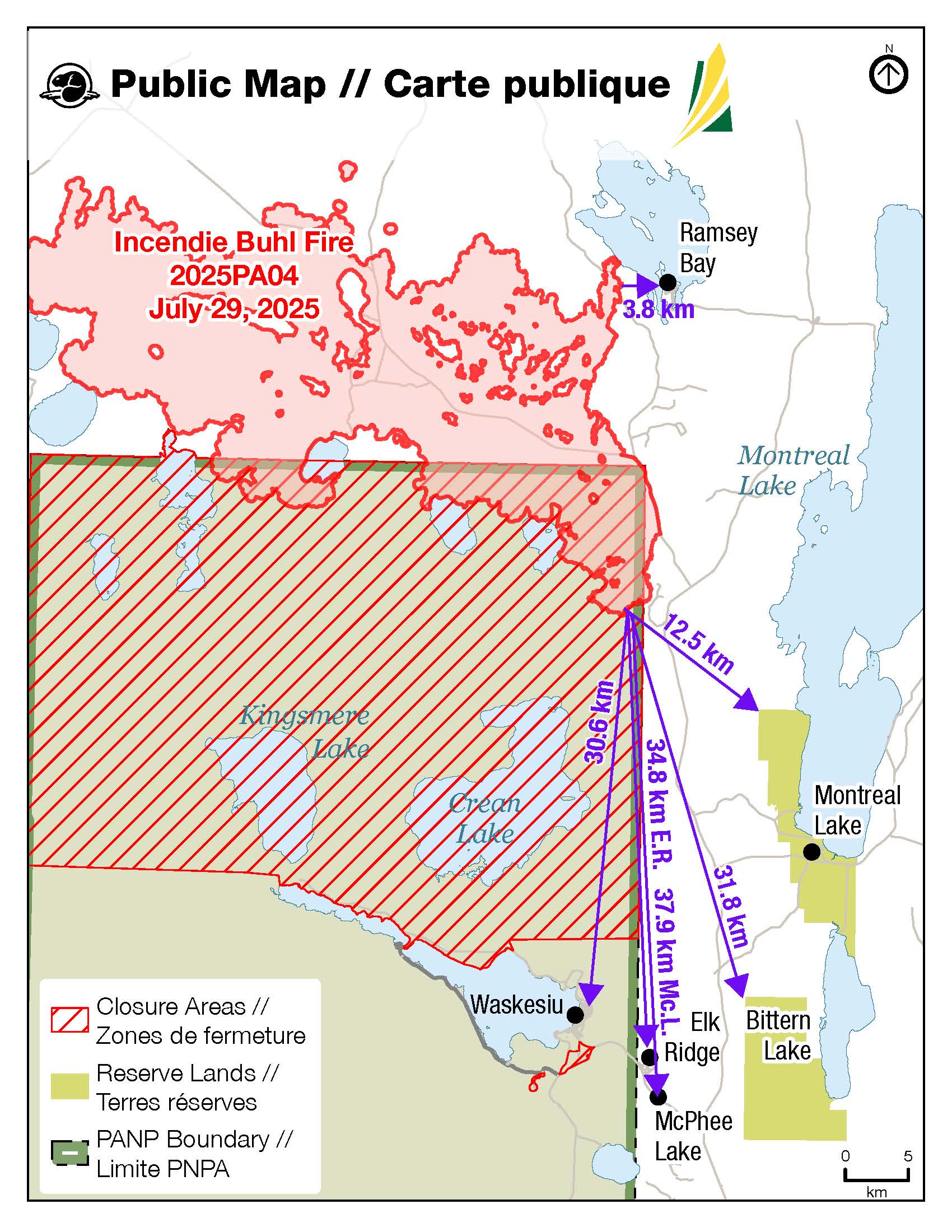
Buhl Fire Update - July 28
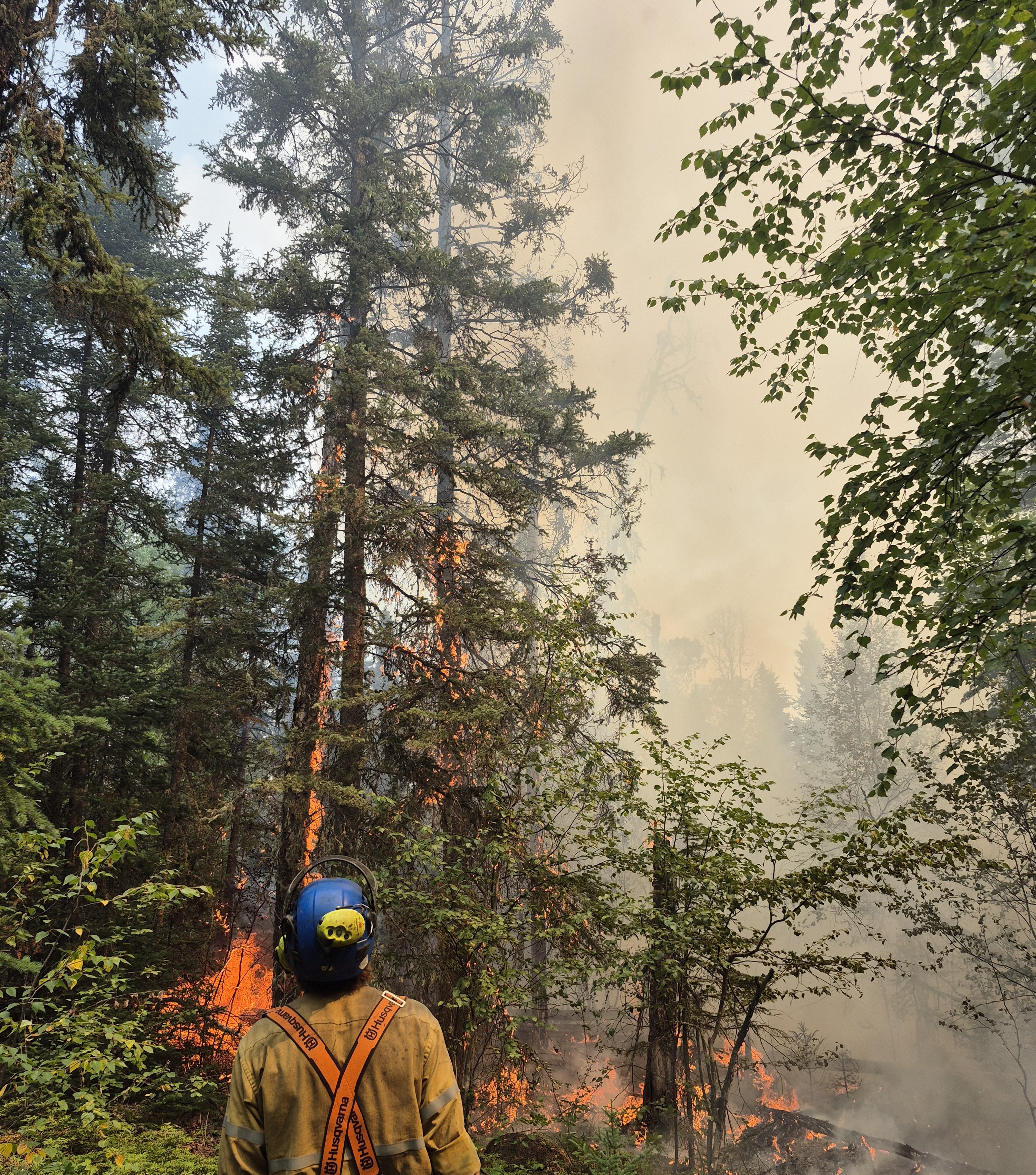
Buhl Fire Information Bulletin – July 28, 2025
Location: Saskatchewan
Fire: Parks Canada – 2025PA04-Buhl, SPSA – 25WY-Buhl
Current as of: July 28, 2025, at 11 am.
Please note that the information provided is current at the time of writing and may be subject to change.
If you see smoke or flames and suspect a wildfire, do not hesitate—call 911 immediately. To report suspicious smoke or wildfires in Prince Albert National Park, call Parks Canada Dispatch at 780 852 3100 (toll free 877 852 3100) or Prince Albert National Park at 306 663 4522.
Your quick action can save lives, protect homes, and help emergency responders contain the fire before it spreads.
SK Wildfire Inquiry Line
Available daily from 8 am to 5 pm. Toll-free: 1-855-559-5502
Situation Reports are posted daily and can be found on the Sk Publications Website and on the Prince Albert National Park website.
Visual information is located on the SPSA Interactive Wildfire Map.
For more information regarding wildfire weather and smoke, please visit FireSmoke Canada.
To learn more about highway conditions, including closures, please visit Sk Highway Hotline.
Community Status Update: For additional information on the current status of communities impacted by the Buhl Fire, refer to the local jurisdiction.
Saskatchewan Parks, Culture and Sport, and Northern Municipal Services declared a local emergency and an evacuation order for the Resort Subdivision of Ramsey Bay and Ramsey Bay Campground on July 24, 2025. All residents are required to evacuate as soon as possible. For more information, call 1-855-559-5502.
Montreal Lake Cree Nation issued an evacuation for priority one and priority two residents on July 13, 2025, due to the dense, persistent wildfire smoke in the community. This order remains in effect. For more information, contact Dean Henderson or Lionel Bird.
Parks Canada reissued a pre-evacuation alert for Prince Albert National Park on July 26, 2025, due to the Buhl Wildfire that has potential to cause emergency situations for the public, including deteriorating air quality and or visibility due to wildfire smoke. For more information, see Saskalerts.ca
Elk Ridge and McPhee Lake do not currently have any alerts or orders in effect.
Closures and Fire Ban
Prince Albert National Park has area closures in effect for the northern area of the park, Overflow Campground area and the Beartrap Helipad. Violating an area closure has serious consequences and may put your safety or others at risk. There is also a fire ban in effect. For more information on area closures and the fire ban, see the Important Bulletins page of the Prince Albert National Park website.
In addition, the Saskatchewan Public Safety Agency issued a fire ban effective at 8 am on July 10, 2025, due to high fire activity and extreme fire risk. The ban encompasses the area north of the provincial forest boundary, up to the Churchill River.
Buhl Fire Summary
The Buhl Fire, first identified on June 29, 2025, was caused by a lightning strike and has burned approximately 76,297 hectares – 12,514 hectares within park boundaries and 63,783 hectares on provincial Crown land. Current resources assigned to the incident include 224 personnel (not including additional SPSA support staff), 11 helicopters, one infrared scanning drone and 9 pieces of heavy equipment. The Buhl Fire response also has access to additional air support as and if required, including air tankers and water tenders.
Provincial Operation Level: Level 4 - Enhanced Operation, District Response/District EOC activated.
Fire Distance from Communities: Please note these are approximations and not exact distances. This information is only provided as a reference. Continue to monitor and follow instructions provided through the various emergency channels.
There were no significant changes in distances between communities and the Buhl Fire since yesterday.
• Ramsey Bay – 4.1 km.
• Montreal Lake – 12.5 km.
• Waskesiu – 30.6 km.
• Bittern Lake – 31.8 km.
• Elk Ridge – 34.8 km.
• McPhee Lake – 37.9 km.
Weather Forecast
Good overnight recovery expected. Surface inversion expected to break by 7:30 am but an inversion aloft (~ 2km) will linger throughout much of the day. Partly cloudy but mainly sunny skies today. Light smoke in morning but starting to build around 3 pm.
Maximum temperature: 20°C. Minimum relative humidity: 30%. Winds: W-NW 5-15 km/h with gusts up to 25 km/h. Precipitation: Nil
Incident Command Objective
Parks Canada and the Saskatchewan Public Safety Agency are operating under a Unified Command structure, ensuring a coordinated and collaborative approach to managing the incident and aligning operational objectives, resource sharing, and public communication.
Objectives for managing this incident are ensuring public safety, protecting critical infrastructure, and preserving valued natural and cultural resources. Collaboration between Parks Canada and the Saskatchewan Public Safety Agency allows for a coordinated wildfire response and sharing of timely and accurate information. Control and suppression efforts are aimed at limiting the spread of the wildfire perimeter, primarily in the direction of nearby communities and values at risk. Strategies will include maintaining safe and open access along key highways and roads and safeguarding community structures.
Operations from July 27
• Scaled-up direct suppression on southeast fire perimeter and along Highway 916 to strengthen containment line. Constructed two helipads on southern edge to increase firefighter access.
• Established pump sites around the northern finger near Ramsay Bay to support future controlled ignition operations as conditions allow and help protect the community.
• Work commenced to create dozer line southeast of Listen Lake towards northwest park boundary, to reinforce barriers to fire spread.
• Continued widening Rock Lake Road to support future controlled ignition operations.
Today’s Focus: The following is the current operational plan for fire crews across the incident zone. Due to the dynamic nature of wildfire response, crews and equipment may be reassigned at any time. This information reflects intentions, not guarantees.
Priorities for Operations for July 28
• Continue completing danger tree assessments and actioning hotspots along Highway 916.
• Continue suppressing fire activity with a hose lay along southeastern edge of fire perimeter.
• Advance dozer line southeast from Listen Lake, then along northwest park boundary.
• Fuel break construction along Rock Lake Road will continue in preparation for future controlled ignition operations.
• Conduct controlled ignition operations west of Rock Lake Road near Ramsay Bay if conditions permit, to help protect the community.
Depending on the circumstances, controlled ignitions can be one of the most effective tools available during wildfire responses. Planned ignitions are carried out to remove vegetation from the path of a fire to slow or halt its growth. This fuel removal work can range from small-scale hand ignitions to large-scale aerial ignitions and is only carried out under very specific conditions.

Buhl Fire Update - July 27
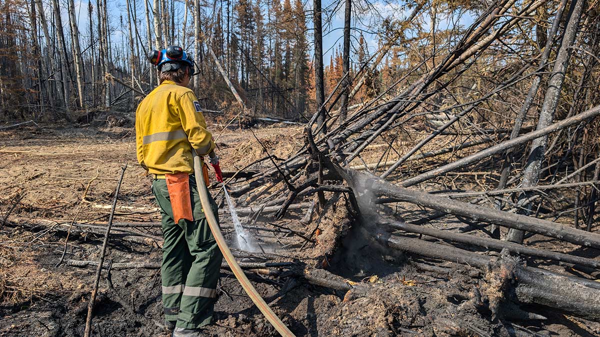
Buhl Fire Information Bulletin – July 27, 2025
Location: Saskatchewan
Fire: Parks Canada – 2025PA04-Buhl, SPSA – 25WY-Buhl
Current as of: July 27, 2025, at 12 pm.
Please note that the information provided is current at the time of writing and may be subject to change.
If you see smoke or flames and suspect a wildfire, do not hesitate—call 911 immediately. To report suspicious smoke or wildfires in Prince Albert National Park, call Parks Canada Dispatch at 780 852 3100 (toll free 877 852 3100) or Prince Albert National Park at 306 663 4522.
Your quick action can save lives, protect homes, and help emergency responders contain the fire before it spreads.
SK Wildfire Inquiry Line
Available daily from 8 am to 5 pm. Toll-free: 1-855-559-5502
Situation Reports are posted daily and can be found on the Sk Publications Website and on the Prince Albert National Park website.
Visual information is located on the SPSA Interactive Wildfire Map.
For more information regarding wildfire weather and smoke, please visit FireSmoke Canada.
To learn more about highway conditions, including closures, please visit Sk Highway Hotline.
Community Status Update: For additional information on the current status of communities impacted by the Buhl Fire, refer to the local jurisdiction.
Saskatchewan Parks, Culture and Sport, and Northern Municipal Services declared a local emergency and an evacuation order for the Resort Subdivision of Ramsey Bay and Ramsey Bay Campground on July 24, 2025. All residents are required to evacuate as soon as possible. For more information, call 1-855-559-5502.
Montreal Lake Cree Nation issued an evacuation for priority one and priority two residents on July 13, 2025, due to the dense, persistent wildfire smoke in the community. This order remains in effect. For more information, contact Dean Henderson or Lionel Bird.
Parks Canada reissued a pre-evacuation alert for Prince Albert National Park on July 26, 2025, due to the Buhl Wildfire that has potential to cause emergency situations for the public, including deteriorating air quality and or visibility due to wildfire smoke. For more information, see Saskalerts.ca
Elk Ridge and McPhee Lake do not currently have any alerts or orders in effect.
Closures and Fire Ban
Prince Albert National Park has area closures in effect for the northern area of the park, Overflow Campground area and the Beartrap Helipad. Violating an area closure has serious consequences and may put your safety or others at risk. There is also a fire ban in effect. For more information on area closures and the fire ban, see the Important Bulletins page of the Prince Albert National Park website.
In addition, the Saskatchewan Public Safety Agency issued a fire ban effective at 8 a.m. on July 10, 2025, due to high fire activity and extreme fire risk. The ban encompasses the area north of the provincial forest boundary, up to the Churchill River.
Buhl Fire Summary
The Buhl Fire, first identified on June 29, 2025, was caused by a lightning strike and has burned approximately 76,189 hectares – 12,514 hectares within park boundaries and 63,675 hectares on provincial Crown land. Current resources assigned to the incident include 187 personnel not including additional SPSA support staff, 11 helicopters, one infrared scanning drone and 9 pieces of heavy equipment. The Buhl Fire response also has access to additional air support as and if required, including air tankers and water tenders.
Provincial Operation Level: Level 4 - Enhanced Operation, District Response/District EOC activated
Fire Distance from Communities: Please note these are approximations and not exact distances. This information is only provided as a reference. Continue to monitor and follow instructions provided through the various emergency channels.
There were no significant changes in distances between communities and the Buhl Fire since yesterday. Minor changes in distance are attributed to enhanced mapping and wildfire perimeter data:
- Ramsey Bay – 4.1 km.
- Montreal Lake – 12.5 km.
- Waskesiu – 30.6 km.
- Bittern Lake – 31.8 km.
- Elk Ridge – 34.8 km.
- McPhee Lake – 37.9 km.
Weather Forecast
Good overnight recovery with inversion expected to break by 9 am. Mostly cloudy skies today with
some breaks of sun. Chance of showers and risk of thundershowers in the afternoon.
Max temperature: 21°C. Minimum relative humidity: 40%. Winds: N 5-15 with gusts up to 25km/h. Trace precipitation expected.
Incident Command Objective
Parks Canada and the Saskatchewan Public Safety Agency are operating under a Unified Command structure, ensuring a coordinated and collaborative approach to managing the incident and aligning operational objectives, resource sharing, and public communication.
Objectives for managing this incident are ensuring public safety, protecting critical infrastructure, and preserving valued natural and cultural resources. Collaboration between Parks Canada and the Saskatchewan Public Safety Agency allows for a coordinated wildfire response and sharing of timely and accurate information. Control and suppression efforts are aimed at limiting the spread of the wildfire perimeter, primarily in the direction of nearby communities and values at risk. Strategies will include maintaining safe and open access along key highways and roads and safeguarding community structures.
Operations from July 26
- Completed dozer line along northern finger of fire near Ramsey Bay to limit easterly spread towards community.
- Continued direct suppression activities along southern perimeter.
- Continued creating contingency line with heavy equipment by Montreal Lake Cree Nation.
- Completed dozer line between Clarke Lake and Listen Lake to limit western and southern spread.
- Maintained structural protection resources to limit threat to values at risk around perimeter.
Today’s Focus: The following is the current operational plan for fire crews across the incident zone. Due to the dynamic nature of wildfire response, crews and equipment may be reassigned at any time. This information reflects intentions, not guarantees.
Priorities for Operations for July 27
- If conditions permit, conduct fuel removal operation between northern finger and Ramsey Bay to further limit risk to the community.
- Create dozer line South of Listen Lake, along Northwest boundary of the national park to limit further spread.
- Further increase direct suppression on southeast fire perimeter based on overnight drone hotspot data.
- Maintain protection on outlying values at risk around the fire perimeter.
While most resources remain committed to managing the Buhl Wildfire, Parks Canada fire personnel are also patrolling Prince Albert National Park twice a day to action any new or additional starts in the park.
Fire Map: Last Updated – 11 am, July 25, 2025
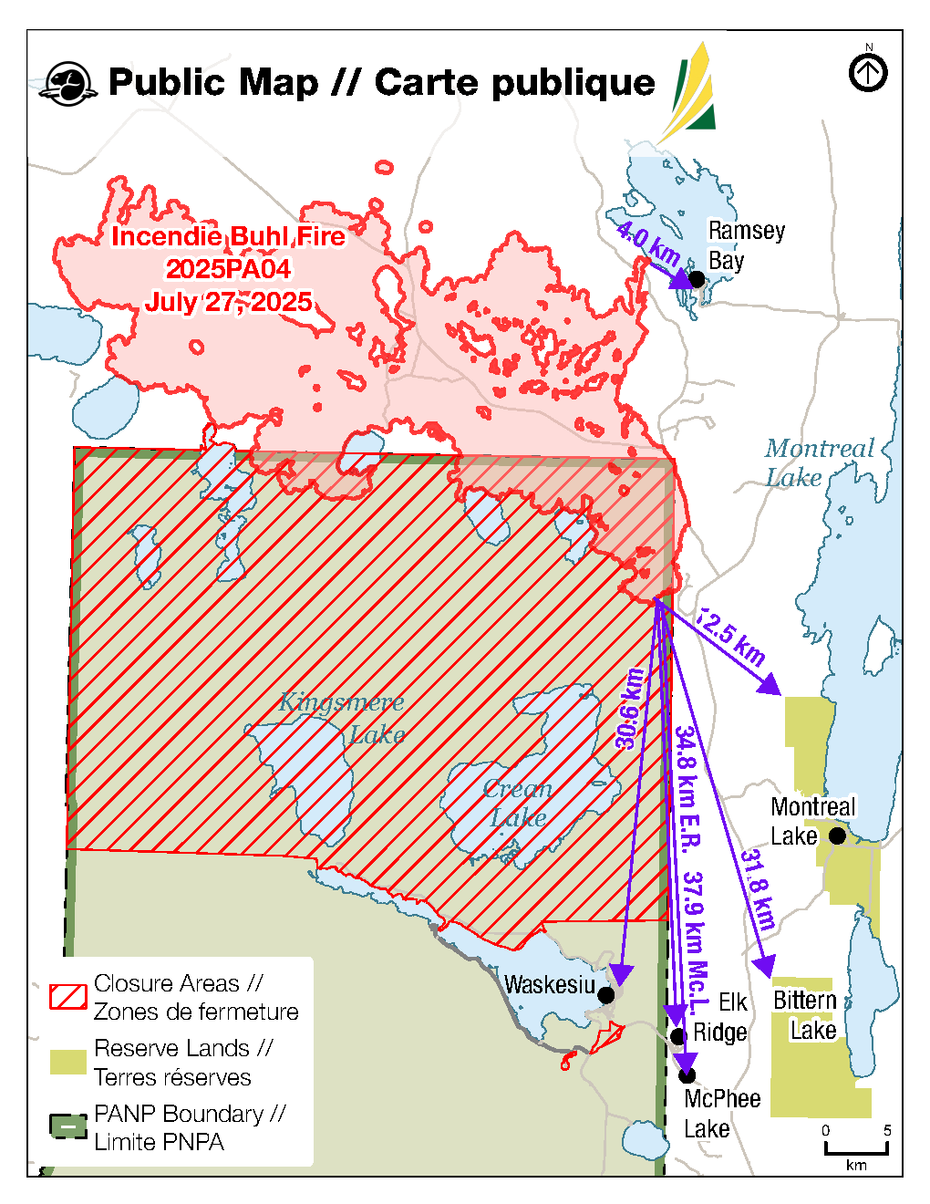
Buhl Fire Update - July 26
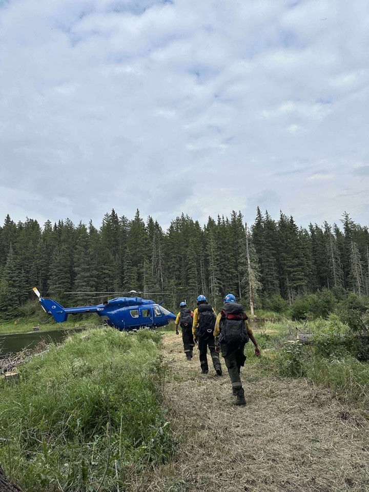
Buhl Fire Information Bulletin – July 26, 2025
Location: Saskatchewan
Fire: Parks Canada – 2025PA04-Buhl, SPSA – 25WY-Buhl
Current as of: July 26, 2025, at 12:00 p.m.
Please note that the information provided is current at the time of writing and may be subject to change.
If you see smoke or flames and suspect a wildfire, do not hesitate—call 911 immediately. To report suspicious smoke or wildfires in Prince Albert National Park, call Parks Canada Dispatch at 780 852 3100 (toll free 877 852 3100) or Prince Albert National Park at 306 663 4522.
Your quick action can save lives, protect homes, and help emergency responders contain the fire before it spreads.
SK Wildfire Inquiry Line
Available daily from 8:00 a.m. to 5:00 p.m. Toll-free: 1-855-559-5502
Situation Reports are posted daily and can be found on the Sk Publications Website and on the Prince Albert National Park website.
Visual information is located on the SPSA Interactive Wildfire Map.
For more information regarding wildfire weather and smoke, please visit FireSmoke Canada.
To learn more about highway conditions, including closures, please visit Sk Highway Hotline.
Community Status Update: For additional information on the current status of communities impacted by the Buhl Fire, refer to the local jurisdiction.
Saskatchewan Parks, Culture and Sport, and Northern Municipal Services declared a local emergency and an evacuation order for the Resort Subdivision of Ramsey Bay and Ramsey Bay Campground on July 24, 2025. All residents are required to evacuate as soon as possible. For more information, call 1-855-559-5502.
Montreal Lake Cree Nation issued an evacuation for priority one and priority two residents on July 13, 2025, due to the dense, persistent wildfire smoke in the community. This order remains in effect. For more information, contact Dean Henderson or Lionel Bird.
Parks Canada reissued a pre-evacuation alert for Prince Albert National Park on July 26, 2025, due to the Buhl Wildfire that has potential to cause emergency situations for the public, including deteriorating air quality and or visibility due to wildfire smoke. For more information, see Saskalerts.ca
Elk Ridge and McPhee Lake do not currently have any alerts or orders in effect.
Closures and Fire Ban
Prince Albert National Park has area closures in effect for the northern area of the park, Overflow Campground area and the Beartrap Helipad. There is also a fire ban in effect. For more information on area closures and the fire ban, see the Important Bulletins page of the Prince Albert National Park website.
In addition, the Saskatchewan Public Safety Agency issued a fire ban effective at 8 a.m. on July 10, 2025, due to high fire activity and extreme fire risk. The ban encompasses the area north of the provincial forest boundary, up to the Churchill River.
Buhl Fire Summary
The Buhl Fire, first identified on June 29, 2025, was caused by a lightning strike and has burned approximately 76,234 hectares – 12, 562 hectares within park boundaries and 63,672 hectares on provincial Crown land. Current resources assigned to the incident include 207 personnel not including additional SPSA support staff, 11 helicopters, one infrared scanning drone and 9 pieces of heavy equipment. The Buhl Fire response also has access to additional air support as and if required, including water tankers.
Provincial Operation Level: Level 4 - Enhanced Operation, District Response/District EOC activated
Fire Distance from Communities: Please note these are approximations and not exact distances. This information is only provided as a reference. Continue to monitor and follow instructions provided through the various emergency channels.
There was no significant growth towards communities on July 25.
Ramsey Bay – 4 km.
Montreal Lake – 12.5 km.
Waskesiu – 30.5 km.
Bittern Lake – 31.8 km.
Elk Ridge – 34.7 km.
McPhee Lake – 37.8 km.
Weather Forecast
Mix of sun and clouds in the morning with mostly cloudy skies and a chance of rain later in the day.
Max Temp: 23C, Min RH: 35%, Winds: W-NW5-10 with gusts up to 20 - 25 km/h, Precipitation: trace
Incident Command Objective
Parks Canada and the Saskatchewan Public Safety Agency are operating under a Unified Command structure, ensuring a coordinated and collaborative approach to managing the incident and aligning operational objectives, resource sharing, and public communication.
Objectives for managing this incident are ensuring public safety, protecting critical infrastructure, and preserving valued natural and cultural resources. Collaboration between Parks Canada and the Saskatchewan Public Safety Agency allows for a coordinated wildfire response and sharing of timely and accurate information. Control and suppression efforts are aimed at limiting the spread of the wildfire perimeter, primarily in the direction of nearby communities and values at risk. Strategies will include maintaining safe and open access along key highways and roads and safeguarding community structures.
Operations from July 25
- Established Cat line between northern finger of fire and Ramsey Bay to limit easterly spread towards community. Mobilized structural protection to limit threat to values at risk in Ramsey Bay. Held contingency lines with bucketing operations to limit further spread towards Ramsey Bay.
- Held control line on eastern fire perimeter by Cheeyas Lake and established helicopter pads to maintain access to the area.
- Held control line north of Bell Lake with crews and heavy equipment. Extinguished hot spots along the 916 Road to limit threat to Highway 2.
- Began strengthening control line by Crean River to limit southerly spread and identified future holding lines between Tibiska Lake and Wassegam Lake.
- Began dozer line on western fire perimeter between Listen Lake and Clarke Lake with heavy equipment to limit westerly spread.
- Monitored and maintained value protection on outlying values at risk around the fire perimeter.
Today’s Focus: The following is the current operational plan for fire crews across the incident zone. Due to the dynamic nature of wildfire response, crews and equipment may be reassigned at any time. This information reflects intentions, not guarantees.
Priorities for Operations for July 26
- Air operations will prioritize limiting northerly spread to limit the threat to Ramsey Bay.
- Continue establishing Cat line between northern finger of fire and Ramsey Bay with heavy equipment and hose lay to limit easterly spread towards community.
- Continue strengthening control line by Crean River with sprinkler lay and plan for future controlled ignition operations to limit southerly and easterly spread.
- Maintain structural protection resources to limit threat to values at risk in Ramsey Bay.
- Extinguish hotspots from previous controlled ignition operations by Cheeyas Lake and Rock Lake Road with crews and water tenders to limit threat to Highway 2. Widen Rock Lake Road for future control line.
- Continue establishing control line on western fire perimeter with industry partners’ heavy equipment to limit continued westerly spread and conduct controlled ignition operations if conditions allow.
- Monitor and maintain protection on outlying values at risk around the fire perimeter.
Fire Map: Last Updated – 10:00 hours, July 26, 2025

Buhl Fire Update - July 25
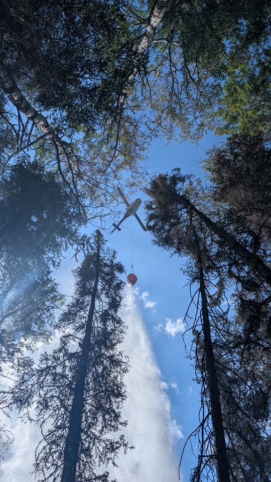
Buhl Fire Information Bulletin – July 25, 2025
Location: Saskatchewan
Fire: Parks Canada – 2025PA04-Buhl, SPSA – 25WY-Buhl
Current as of: July 25, 2025, at 12:00 p.m.
Please note that the information provided is current at the time of writing and may be subject to change.
If you see smoke or flames and suspect a wildfire, do not hesitate—call 911 immediately. To report suspicious smoke or wildfires in Prince Albert National Park, call Parks Canada Dispatch at 780 852 3100 (toll free 877 852 3100) or Prince Albert National Park at 306 663 4522.
Your quick action can save lives, protect homes, and help emergency responders contain the fire before it spreads.
SK Wildfire Inquiry Line
Available daily from 8:00 a.m. to 5:00 p.m. Toll-free: 1-855-559-5502
Situation Reports are posted daily and can be found on the Sk Publications Website and on the Prince Albert National Park website.
Visual information is located on the SPSA Interactive Wildfire Map.
For more information regarding wildfire weather and smoke, please visit FireSmoke Canada.
To learn more about highway conditions, including closures, please visit Sk Highway Hotline.
Community Status Update: For additional information on the current status of communities impacted by the Buhl Fire, refer to the local jurisdiction.
Saskatchewan Parks, Culture and Sport, and Northern Municipal Services declared a local emergency and an evacuation order for the Resort Subdivision of Ramsey Bay and Ramsey Bay Campground on July 24, 2025. All residents are required to evacuate as soon as possible. For more information, call 1-855-559-5502.
Montreal Lake Cree Nation issued an evacuation for priority one and priority two residents on July 13, 2025, due to the dense, persistent wildfire smoke in the community. This order remains in effect. For more information, contact Dean Henderson or Lionel Bird.
Parks Canada reissued a pre-evacuation alert for Prince Albert National Park on July 20, 2025, due to the Buhl Wildfire that has potential to cause emergency situations for the public, including deteriorating air quality and or visibility due to wildfire smoke. For more information, see Saskalerts.ca
Elk Ridge and McPhee Lake do not currently have any alerts or orders in effect.
Closures and Fire Ban
Prince Albert National Park has area closures in effect for the northern area of the park, Overflow Campground area and the Beartrap Helipad. There is also a fire ban in effect. For more information on area closures and the fire ban, see the Important Bulletins page of the Prince Albert National Park website.
In addition, the Saskatchewan Public Safety Agency issued a fire ban effective at 8 a.m. on July 10, 2025, due to high fire activity and extreme fire risk. The ban encompasses the area north of the provincial forest boundary, up to the Churchill River.
Buhl Fire Summary
The Buhl Fire, first identified on June 29, 2025, was caused by a lightning strike and has burned approximately 74, 364 hectares – 12, 313 hectares within park boundaries and 62, 050 hectares on provincial Crown land. Current resources assigned to the incident include 169 personnel not including additional SPSA support staff, 11 helicopters, one infrared scanning drone and 9 pieces of heavy equipment. The Buhl Fire response also has access to additional air support as and if required, including water tankers.
Provincial Operation Level: Level 4 - Enhanced Operation, District Response/District EOC activated
Fire Distance from Communities: Please note these are approximations and not exact distances. This information is only provided as a reference. Continue to monitor and follow instructions provided through the various emergency channels.
The fire progressed towards the community of Ramsey Bay on July 24, but did not make significant progress towards other communities on July 24.
Ramsey Bay – 4 km.
Montreal Lake – 12.5 km.
Waskesiu – 30.5 km.
Bittern Lake – 31.8 km.
Elk Ridge – 34.7 km.
McPhee Lake – 37.8 km.
Weather Forecast
Mostly cloudy skies with chance of showers. Risk of thundershowers that may bring up to 10 mm of rain and wind gusts up to 80 km/hr with risk of hail in strong or severe thunderstorms.
Max Temp: 24C, Min RH: 30%, Winds: W15 - 25km/hr with gusts up to 35-40 km/h, Precipitation: approx.. 2 mm, possibly more in thundershowers.
Incident Command Objective
Parks Canada and the Saskatchewan Public Safety Agency are operating under a Unified Command structure, ensuring a coordinated and collaborative approach to managing the incident and aligning operational objectives, resource sharing, and public communication.
Objectives for managing this incident are ensuring public safety, protecting critical infrastructure, and preserving valued natural and cultural resources. Collaboration between Parks Canada and the Saskatchewan Public Safety Agency allows for a coordinated wildfire response and sharing of timely and accurate information. Control and suppression efforts are aimed at limiting the spread of the wildfire perimeter, primarily in the direction of nearby communities and values at risk. Strategies will include maintaining safe and open access along key highways and roads and safeguarding community structures.
Operations from July 24
- Continued establishing contingency line north of Cheeyas Lake with crews supported by controlled ignition operations, air bucketing operations and retardant drops to limit spread to Ramsey Bay. Continued establishing control line with heavy equipment and sprinkler lay south of Ramsey Bay.
- Held control line on the southerly finger of the Buhl Fire with direct ground suppression and air bucketing support to limit easterly and southerly spread.
- Held control line north of Bell Lake with crews, controlled ignition operations and sprinklers to limit threat to Highway 2.
- Began dozer line on western fire perimeter between Listen Lake and Clarke Lake with heavy equipment to limit westerly spread.
- Monitored and maintained value protection on outlying values at risk around the fire perimeter.
Today’s Focus: The following is the current operational plan for fire crews across the incident zone. Due to the dynamic nature of wildfire response, crews and equipment may be reassigned at any time. This information reflects intentions, not guarantees.
Priorities for Operations for July 25
- Air operations will prioritize limiting northerly spread to limit the threat to Ramsey Bay.
- Continue to hold contingency line north of Cheeyas Lake with crews and aerial support to limit northerly spread. Continue work on control line south of Ramsey Bay and mobilize structural protection resources to limit threat to values at risk in Ramsey Bay.
- Hold control line between Cheeyas Lake and Rock Lake Road with ground suppression and air bucketing support to limit threat to Highway 2.
- Continue direct ground suppression with crews to hold control line on southerly finger of fire.
- Continue establishing control line on western fire perimeter with industry partners’ heavy equipment to limit continued westerly spread and conduct controlled ignition operations if conditions allow.
- Monitor and maintain protection on outlying values at risk around the fire perimeter.
Fire Map: Last Updated – 11:00 hours, July 25, 2025
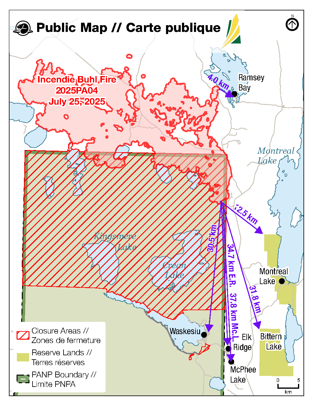
Buhl Fire Update - July 24
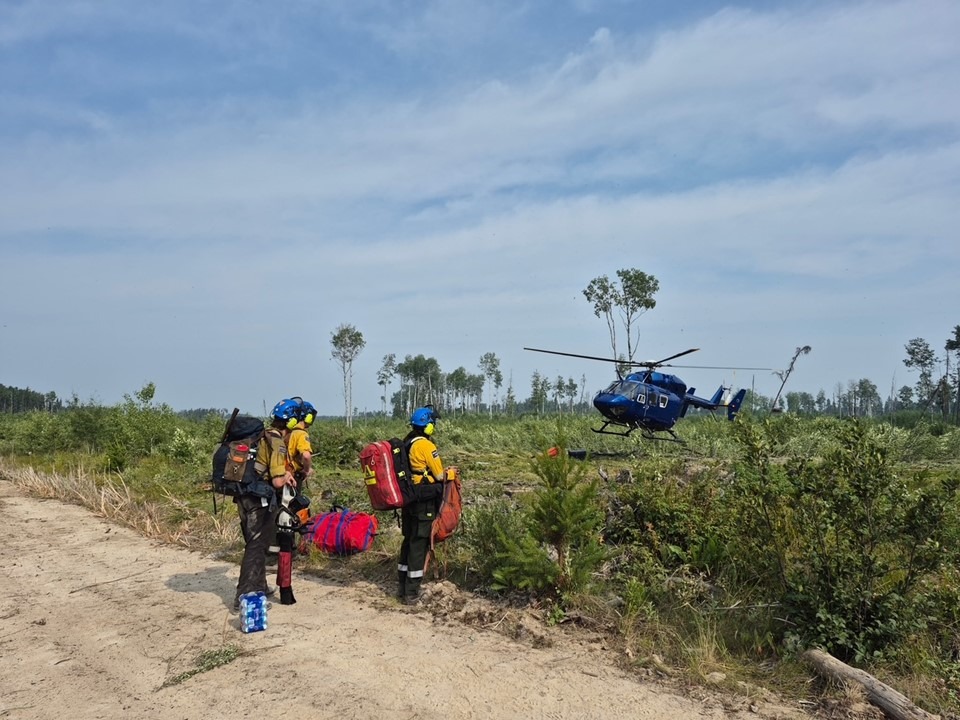
Buhl Fire Information Bulletin – UPDATE - July 24, 2025
Location: Saskatchewan
Fire: Parks Canada – 2025PA04-Buhl, SPSA – 25WY-Buhl
Current as of: July 24, 2025, at 4:00 p.m.
Saskatchewan Parks, Culture and Sport, and Northern Municipal Services declared a Local Emergency and General Evacuation Order for the Resort Subdivision of Ramsey Bay and Ramsey Bay Campground on July 24, 2025. All residents are required to evacuate as soon as possible.
Permanent residents who require assistance should register online on the SPSA Evacuation App (https://app.saskecs.ca/) and call 1-855-559-5502 to process food security support if you are not staying at an evacuation site that provides food.
If you require accommodations, please proceed to the Days Inn in Prince Albert Room 106 to register. Pets are not allowed.
For more information, call 1-855-559-5502
Buhl Fire Information Bulletin – July 24, 2025
Location: Saskatchewan
Fire: Parks Canada – 2025PA04-Buhl, SPSA – 25WY-Buhl
Current as of: July 24, 2025, at 12:00 p.m.
Please note that the information provided is current at the time of writing and may be subject to change.
If you see smoke or flames and suspect a wildfire, do not hesitate—call 911 immediately. To report suspicious smoke or wildfires in Prince Albert National Park, call Parks Canada Dispatch at 780 852 3100 (toll free 877 852 3100) or Prince Albert National Park at 306 663 4522.
Your quick action can save lives, protect homes, and help emergency responders contain the fire before it spreads.
SK Wildfire Inquiry Line
Available daily from 8:00 a.m. to 5:00 p.m. Toll-free: 1-855-559-5502
Situation Reports are posted daily and can be found on the Sk Publications Website and on the Prince Albert National Park website.
Visual information is located on the SPSA Interactive Wildfire Map.
For more information regarding wildfire weather and smoke, please visit FireSmoke Canada.
To learn more about highway conditions, including closures, please visit Sk Highway Hotline.
Community Status Update: For additional information on the current status of communities impacted by the Buhl Fire, refer to the local jurisdiction.
There is an evacuation alert in effect for Ramsey Bay, including the Weyakwin Lake Recreation Site. Visitors and residents are not required to leave at this time but should be prepared to evacuate on short notice. For more information on how to prepare for an evacuation, see the Saskatchewan Public Safety Agency website.
Montreal Lake Cree Nation issued an evacuation for priority one and priority two residents on July 13, 2025, due to the dense, persistent wildfire smoke in the community. This order remains in effect. For more information, contact Dean Henderson or Lionel Bird.
Parks Canada reissued a pre-evacuation alert for Prince Albert National Park on July 20, 2025, due to the Buhl Wildfire that has potential to cause emergency situations for the public, including deteriorating air quality and or visibility due to wildfire smoke. For more information, see Saskalerts.ca
Elk Ridge and McPhee Lake do not currently have any alerts or orders in effect.
Closures and Fire Ban
Prince Albert National Park extended the northern area closure on July 23, 2025, to include the Kingsmere road west of the Heart Lakes Access Road. The area closures for the Overflow Campground area and the Beartrap Helipad remain as well as the fire ban remain in effect. For more information on area closures and the fire ban, see the Important Bulletins page of the Prince Albert National Park website.
In addition, the Saskatchewan Public Safety Agency issued a fire ban effective at 8 a.m. on July 10, 2025, due to high fire activity and extreme fire risk. The ban encompasses the area north of the provincial forest boundary, up to the Churchill River.
Buhl Fire Summary
The Buhl Fire, first identified on June 29, 2025, was caused by a lightning strike and has burned approximately 65 326 hectares – 11 517 hectares within park boundaries and 53 809 hectares on provincial Crown land. Current resources assigned to the incident include 161 personnel not including additional SPSA support staff, 11 helicopters, and 9 pieces of heavy equipment. The Buhl Fire response also has access to additional air support as and if required, including water tankers.
Provincial Operation Level: Level 4 - Enhanced Operation, District Response/District EOC activated
Fire Distance from Communities: Please note these are approximations and not exact distances. This information is only provided as a reference. Continue to monitor and follow instructions provided through the various emergency channels.
The fire progressed towards the community of Ramsey Bay on July 23, but did not make significant progress towards other communities on July 23.
Ramsey Bay – 6.4 km.
Montreal Lake – 12.5 km.
Waskesiu – 30.5 km.
Bittern Lake – 31.8 km.
Elk Ridge – 34.7 km.
McPhee Lake – 37. km.
Weather Forecast
Mostly cloudy skies in the afternoon. A surface inversion should break around noon. Chance of rain later in the evening with possible thundershower and gusty winds overnight.
Max Temp: 23C, Min RH: 30%, Winds: S10-20 km/hr with gusts up to 25 km/h, Precipitation: Nil
Incident Command Objective
Parks Canada and the Saskatchewan Public Safety Agency are operating under a Unified Command structure, ensuring a coordinated and collaborative approach to managing the incident and aligning operational objectives, resource sharing, and public communication.
Objectives for managing this incident are ensuring public safety, protecting critical infrastructure, and preserving valued natural and cultural resources. Collaboration between Parks Canada and the Saskatchewan Public Safety Agency allows for a coordinated wildfire response and sharing of timely and accurate information. Control and suppression efforts are aimed at limiting the spread of the wildfire perimeter, primarily in the direction of nearby communities and values at risk. Strategies will include maintaining safe and open access along key highways and roads and safeguarding community structures.
Operations from July 23
- Held control line on the southerly finger of the Buhl Fire with direct ground suppression and air bucketing support to limit easterly and southerly spread.
- Held control line north of Bell Lake with crews. Monitored and extinguished hot spots along the 916 Road with water truck and heavy equipment to limit threat to Highway 2.
- Continued establishing control line with heavy equipment and sprinkler lay south of Ramsey Bay to limit threat to community.
- Continued establishing a contingency line by Montreal Lake Cree Nation with heavy equipment to limit threat to community.
- Built contingency line north of Cheeyas Lake with retardant drops and hose lay.
- Monitored and maintained value protection on outlying values at risk around the fire perimeter.
- Some planned operations were interrupted because of low visibility from wildfire smoke and unsafe conditions on the ground.
Today’s Focus: The following is the current operational plan for fire crews across the incident zone. Due to the dynamic nature of wildfire response, crews and equipment may be reassigned at any time. This information reflects intentions, not guarantees.
Priorities for Operations for July 24
- Hold control line between Cheeyas Lake and Rock Lake Road with ground suppression and air bucketing support to limit threat to Highway 2. Construct helipads at both ends of Cheeyas Lake to maintain access and support operations.
- Continue direct ground suppression with crews and air bucketing supporting to hold control line on southerly finger of fire.
- Continue establishing a contingency line with heavy equipment south of Ramsey Bay.
- Establish control line on western fire perimeter with industry partners heavy equipment to limit continued westerly spread.
- Monitor and maintain value protection on outlying values at risk around fire perimeter.
Fire Map: Last Updated – 10:30 hours, July 24, 2025
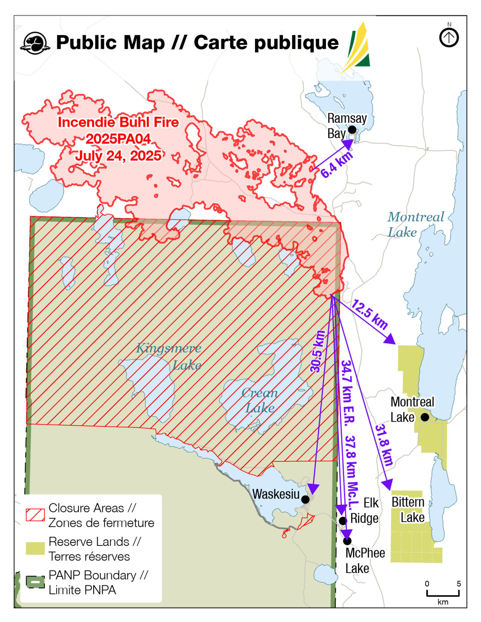
Buhl Fire Update - July 23
Buhl Fire Update - July 22
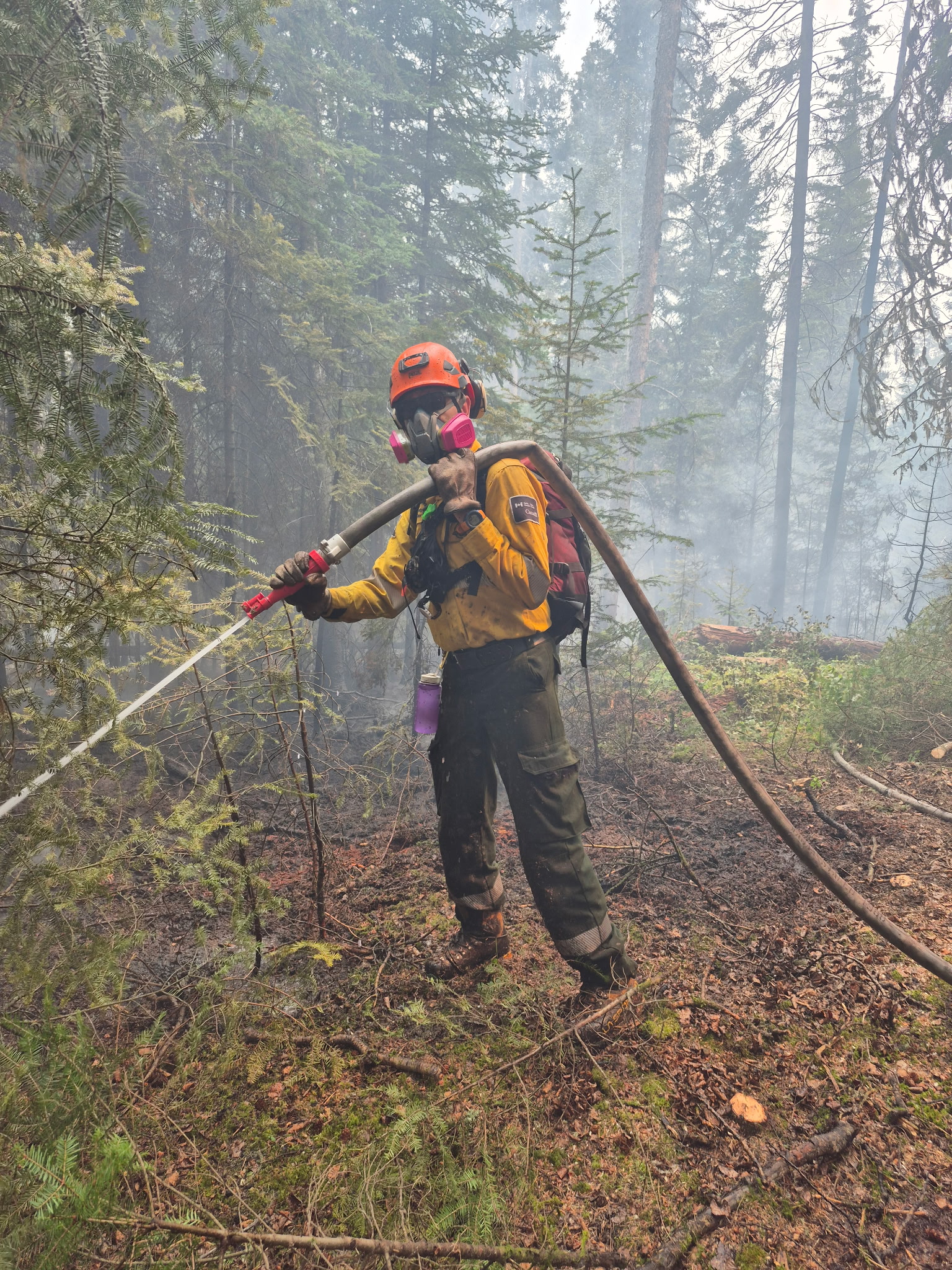
Buhl Fire Information Bulletin – July 22, 2025
Location: Saskatchewan
Fire: Parks Canada – 2025PA04-Buhl, SPSA – 25WY-Buhl
Current as of: July 22, 2025, at 12:00 p.m.
Please note that the information provided is current at the time of writing and may be subject to change.
If you see smoke or flames and suspect a wildfire, do not hesitate—call 911 immediately. To report suspicious smoke or wildfires in Prince Albert National Park, call Parks Canada Dispatch at 780 852 3100 (toll free 877 852 3100) or Prince Albert National Park at 306 663 4522.
Your quick action can save lives, protect homes, and help emergency responders contain the fire before it spreads.
SK Wildfire Inquiry Line
Available daily from 8:00 a.m. to 5:00 p.m. Toll-free: 1-855-559-5502
Situation Reports are posted daily and can be found on the Sk Publications Website and on the Prince Albert National Park website.
Visual information is located on the SPSA Interactive Wildfire Map.
For more information regarding wildfire weather and smoke, please visit FireSmoke Canada.
To learn more about highway conditions, including closures, please visit Sk Highway Hotline.
Community Status Update:
Montreal Lake Cree Nation issued an evacuation for priority one and priority two residents on July 13, 2025, due to the dense, persistent wildfire smoke in the community. This order remains in effect. For more information, contact Dean Henderson or Lionel Bird.
Parks Canada reissued a pre-evacuation alert for Prince Albert National Park on July 20, 2025, due to the Buhl Wildfire that has potential to cause emergency situations for the public, including deteriorating air quality and or visibility due to wildfire smoke. For more information, see Saskalerts.ca.
Ramsey Bay, Elk Ridge and McPhee Lake do not currently have any alerts or orders in effect.
Closures and Fire Ban
Prince Albert National Park closed the Overflow Campground area including the Overflow Campground access road and the Red Deer Trail between Highway 264 and 263, as well as the access road to Beartrap Helipad and Beartrap helipad on July 22, 2025. The area closures for the northern area of Prince Albert National Park and the fire ban remain in effect. For more information on area closures and the fire ban, please see the Important Bulletins page of the Prince Albert National Park website.
In addition, the Saskatchewan Public Safety Agency issued a fire ban effective at 8 a.m. on July 10, 2025, due to high fire activity and extreme fire risk. The ban encompasses the area north of the provincial forest boundary, up to the Churchill River.
Buhl Fire Summary
The Buhl Fire, first identified on June 29, 2025, was caused by a lightning strike and has burned approximately 60 389 hectares – 11 059 hectares within park boundaries and 49 329 hectares on provincial Crown land. Current resources assigned to the incident include 126 personnel not including additional SPSA support staff, 9 helicopters, and 9 pieces of heavy equipment. The Buhl Fire response also has access to additional air support as and if required, including water tankers.
Provincial Operation Level: Level 3 - Provincial Response/Provincial EOC activated
Fire Distance from Communities: Please note these are approximations and not exact distances. This information is only provided as a reference. Continue to monitor and follow instructions provided through the various emergency channels.
There was no significant growth towards communities on July 21.
Ramsey Bay – 8 km.
Montreal Lake – 12 km.
Waskesiu – 30 km.
Bittern Lake – 32 km.
Elk Ridge – 35 km.
McPhee Lake – 38 km.
Weather Forecast – July 22
An upper trough and high pressure/surface ridge will bring mostly cloudy skies and lighter winds.
Max Temp: 21C, Min RH: 30%, Winds: W-NW5-20 km/h, Precipitation: Nil
Incident Command Objective
Parks Canada and the Saskatchewan Public Safety Agency are operating under a Unified Command structure, ensuring a coordinated and collaborative approach to managing the incident and aligning operational objectives, resource sharing, and public communication.
Objectives for managing this incident are ensuring public safety, protecting critical infrastructure, and preserving valued natural and cultural resources. Collaboration between Parks Canada and the Saskatchewan Public Safety Agency allows for a coordinated wildfire response and sharing of timely and accurate information. Control and suppression efforts are aimed at limiting the spread of the wildfire perimeter, primarily in the direction of nearby communities and values at risk. Strategies will include maintaining safe and open access along key highways and roads and safeguarding community structures.
Operations from July 21
· Held and patrolled control line on southerly finger of Buhl fire and continued direct ground suppression to limit easterly and southerly spread.
· Monitored and maintained value protection on outlying values at risk around the fire perimeter.
· Held control line on eastern fire perimeter between MacLennan Lake and the junction of the 916 Road and Rock Road to limit threat to Highway 2. Monitored and extinguished hot spots from previous controlled ignition operations with water trucks.
· Completed control line between Weyakwin Lake and small lake north of Cheeyas Lake.
· Some planned operations on the southern and eastern fire perimeter were interrupted because of low visibility from wildfire smoke and unsafe conditions on the ground.
Today’s Focus: The following is the current operational plan for fire crews across the incident zone. Due to the dynamic nature of wildfire response, crews and equipment may be reassigned at any time. This information reflects intentions, not guarantees.
Priorities for Operations for July 22
· Establish hand line between Cheeyas Lake and Leadley Lake to create a control line on the eastern fire perimeter between MacLennan Lake and Cheeyas Lake to limit threat to Highway 2 and Ramsey Bay.
· Continue hose lay on the southern most part of the fire west of the MacLennan River to limit threat to communities south of fire.
· Monitor and maintain value protection and road access to protect community and critical infrastructure.
· Establish a helicopter pad south shore of the small lake north of Cheeyas Lake to maintain access to northern perimeter of fire. Establish pump and hose lay between Cheeyas Lake and small lake north.
· Continue establishing control line north of Bell Lake with heavy equipment and hoselay. Continue to extinguish hotspots along the 916 Road.
Fire Map: Last Updated – 11:00 hours, July 22, 2025
*Maps will be updated when there are significant changes to the perimeter of the Buhl Wildfire*
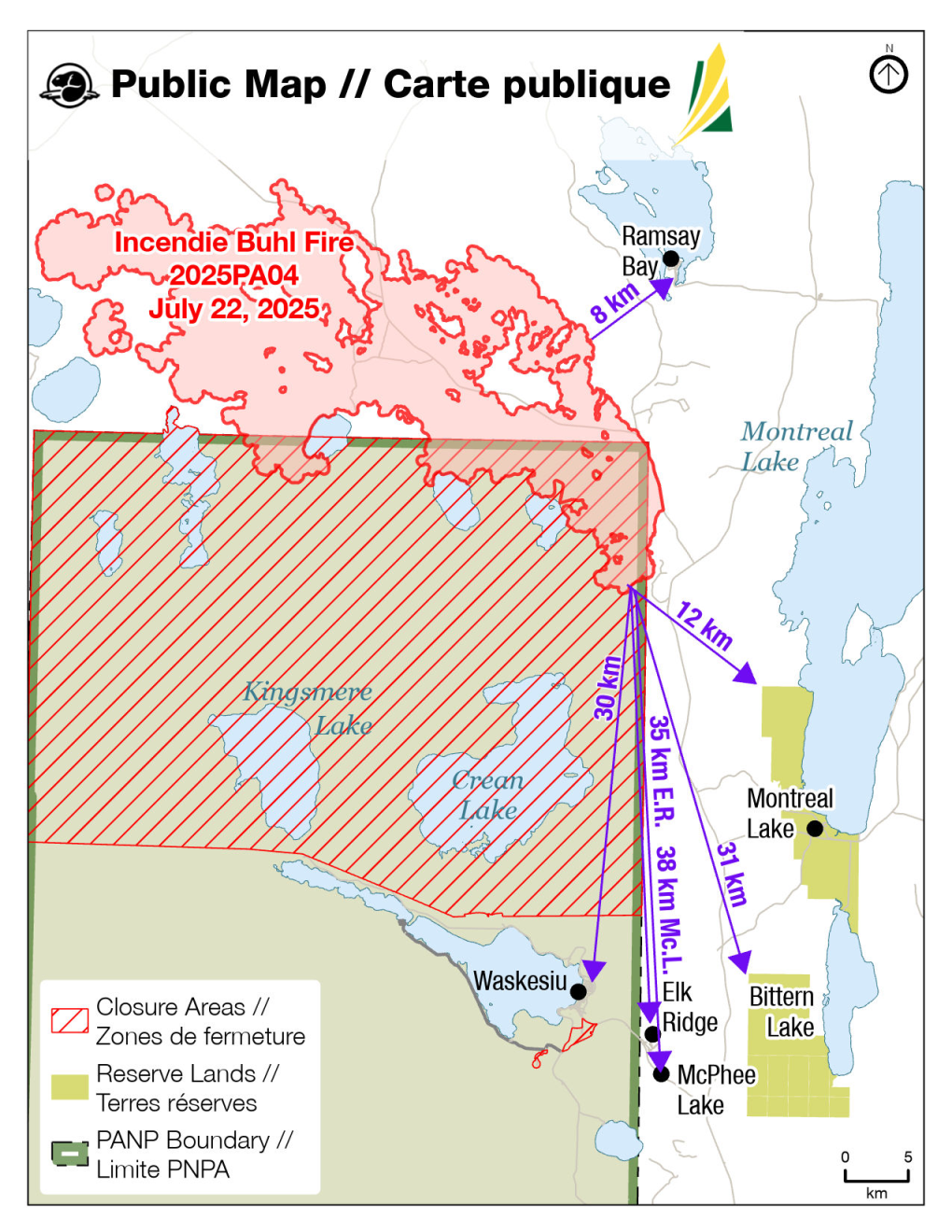
Buhl Fire Update - July 21
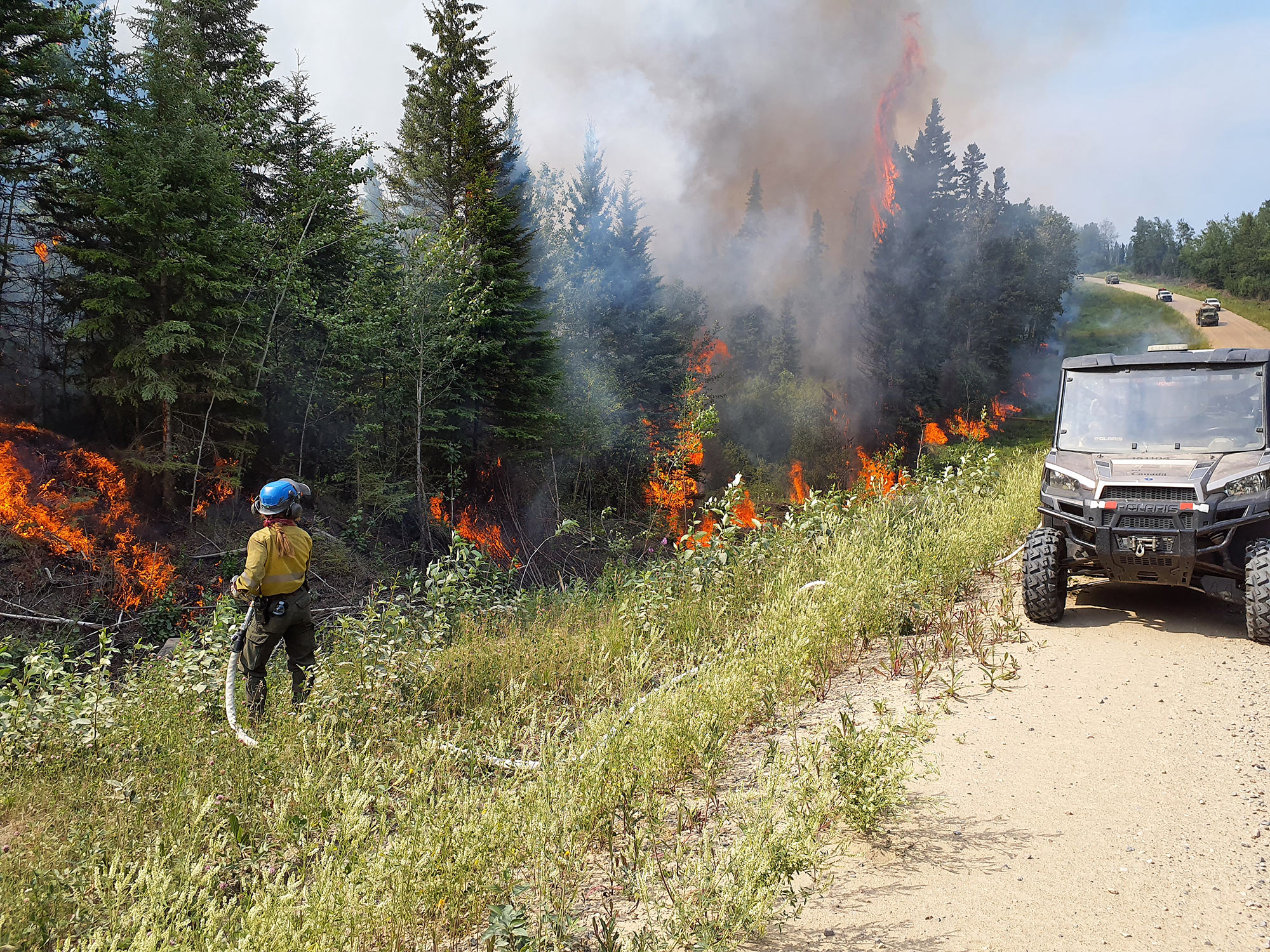
Buhl Fire Information Bulletin – July 21, 2025
Location: Saskatchewan
Fire: Parks Canada – 2025PA04-Buhl, SPSA – 25WY-Buhl
Current as of: July 21, 2025, at 12:00 p.m.
Please note that the information provided is current at the time of writing and may be subject to change.
If you see smoke or flames and suspect a wildfire, do not hesitate— call 911 immediately. To report suspicious smoke or wildfires in Prince Albert National Park, call Parks Canada Dispatch at 780 852 3100 (toll free 877 852 3100) or Prince Albert National Park at 306 663 4522.
Your quick action can save lives, protect homes, and help emergency responders contain the fire before it spreads.
SK Wildfire Inquiry Line
Available daily from 8:00 a.m. to 5:00 p.m. Toll-free: 1-855-559-5502
Situation Reports are posted daily and can be found on the Sk Publications Website and on the Prince Albert National Park website.
Visual information is located on the SPSA Interactive Wildfire Map.
For more information regarding wildfire weather and smoke, please visit FireSmoke Canada.
To learn more about highway conditions, including closures, please visit Sk Highway Hotline.
Incident Command Objective
Parks Canada and the Saskatchewan Public Safety Agency are operating under a Unified Command structure, ensuring a coordinated and collaborative approach to managing the incident and aligning operational objectives, resource sharing, and public communication.
Objectives for managing this incident are ensuring public safety, protecting critical infrastructure, and preserving valued natural and cultural resources. Collaboration between Parks Canada and the Saskatchewan Public Safety Agency allows for a coordinated wildfire response and sharing of timely and accurate information. Control and suppression efforts are aimed at limiting the spread of the wildfire perimeter, primarily in the direction of nearby communities and values at risk. Strategies will include maintaining safe and open access along key highways and roads and safeguarding community structures.
Closures and Fire Ban
The Saskatchewan Public Safety Agency has issued a fire ban effective at 8 a.m. on July 10, 2025, due to high fire activity and extreme fire risk. The ban encompasses the area north of the provincial forest boundary, up to the Churchill River.
Parks Canada has also initiated a fire ban including all of Prince Albert National Park and an area closure for the northern area of Prince Albert National Park, from the northern boundary extending south to include, but not limited to, the Kingsmere Wilderness Area, Crean Lake and area, Heart Lakes and area, Wabeno, Wassegam, Tibiska, Nova and Osten areas. For more information on the fire ban and area closure, please see the Important Bulletins page of the Prince Albert National Park website
Buhl Fire Summary
The Buhl Fire, first identified on June 29, 2025, was caused by a lightning strike and has burned approximately 53,835 hectares – 10,376 hectares within park boundaries and 43,458 hectares on provincial Crown land. Current resources assigned to the incident include 126 personnel not including additional SPSA support staff, 9 helicopters, and 9 pieces of heavy equipment.
Provincial Operation Level: Level 3 - Provincial Response/Provincial EOC activated
Fire Distance from Communities: Please note these are approximations and not exact distances. This information is only provided as a reference. Continue to monitor and follow instructions provided through the various emergency channels.
There was no significant growth towards communities on July 20.
Ramsey Bay – 8 km.
Montreal Lake – 12 km.
Waskesiu – 30 km.
Bittern Lake – 32 km.
Elk Ridge – 35 km.
McPhee Lake – 38 km.
Community Status Update:
Montreal Lake Cree Nation issued an evacuation for priority one and priority two residents on July 13, 2025, due to the dense, persistent wildfire smoke in the community. This order remains in effect. For more information, contact Dean Henderson or Lionel Bird.
Parks Canada reissued a pre-evacuation alert for Prince Albert National Park on July 20, 2025, due to the Buhl Wildfire that has potential to cause emergency situations for the public, including deteriorating air quality and or visibility due to wildfire smoke. For more information, see Saskalerts.ca
Ramsey Bay, Elk Ridge and McPhee Lake do not currently have any alerts or orders in effect.
Weather Forecast – July 21
Forecast for Monday: The low-pressure system exiting the province will bring cloudy skies, increased wind speeds and a chance of light rain showers to the area early in the day. A cold front will move through the region late in the afternoon bringing the risk of thundershowers and gusty winds.
Max Temp: 24C, Min RH: 40%, Winds: - Generally NW10G30 km/h, Precipitation: Trace
Operations from July 20
• Continued direct ground suppression on the southerly finger of the Buhl Fire with crews and support from helicopter bucketing operations to hold it at Bell Lake and limit easterly and southerly spread.
• Monitored, maintained or established new value protection on outlying values at risk around the fire perimeter
• Continued establishing a control line on eastern fire perimeter between MacLennan Lake and Cheeyas Lake. Continued work included ground suppression and controlled ignition operations near Bell Lake and the 916 Road, and between Cheeyas and Leadley Lakes to limit threat to Highway 2 and Ramsey Bay.
Today’s Focus: The following is the current operational plan for fire crews across the incident zone. Due to the dynamic nature of wildfire response, crews and equipment may be reassigned at any time. This information reflects intentions, not guarantees.
Priorities for Operations for July 21
• Monitor and maintain value protection and road access to protect community and critical infrastructure, including establishing a contingency line by Montreal Lake Cree Nation.
• Continued direct ground suppression on the southerly finger of the Buhl fire to hold fire to Bell Lake and limit easterly and southerly spread.
• Monitor and extinguish hotspots from previous controlled ignition operations using float trucks and water tenders along the 916 Road to secure control line.
• Continue establishing control line between McLennan Lake and Cheeyas Lake to limit threat to highway 2 and Ramsey Bay.
• Continue suppression and controlled ignition operations along the 916 Road to establish and hold fire breaks to limit easterly and southerly spread.
Fire Map: Last Updated – 11:00 hours, July 21, 2025
*Maps will be updated when there are significant changes to the perimeter of the Buhl Wildfire*
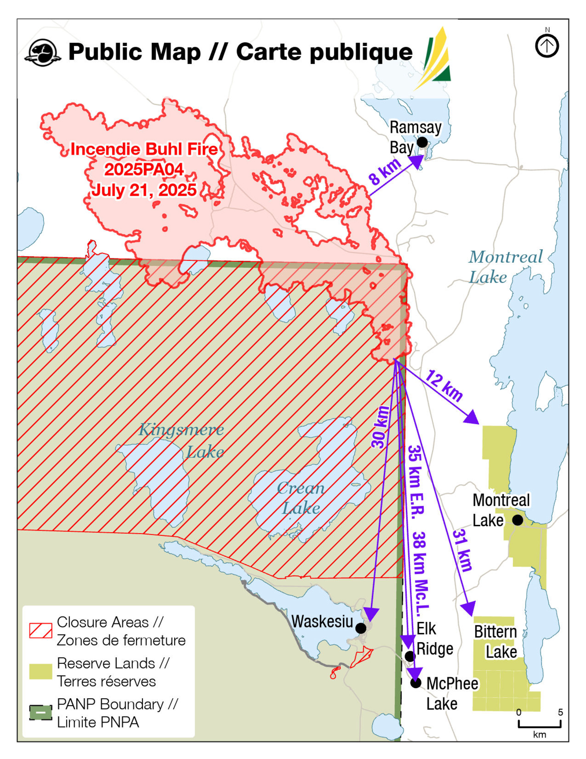
Buhl Fire Update - July 20
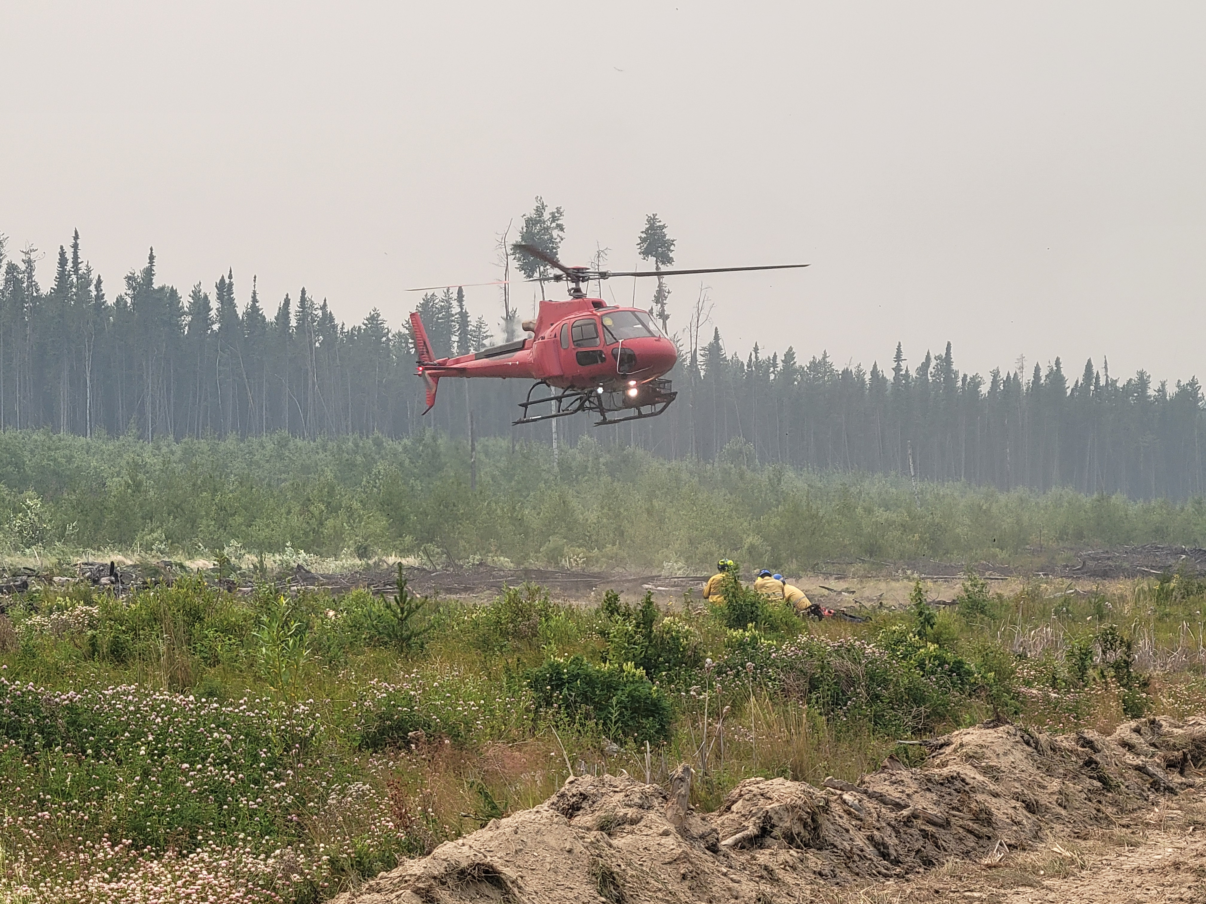
Buhl Fire Information Bulletin – July 20, 2025
Location: Saskatchewan
Fire: Parks Canada – 2025PA04-Buhl, SPSA – 25WY-Buhl
Current as of: July 20, 2025 at 13:00
Please note that the information provided is current at the time of writing and may be subject to change.
If you see smoke or flames and suspect a wildfire, do not hesitate—call 911 immediately. To report suspicious smoke or wildfires in Prince Albert National Park, call Parks Canada Dispatch at 780 852 3100 (toll free 877 852 3100) or Prince Albert National Park at 306 663 4522.
Your quick action can save lives, protect homes, and help emergency responders contain the fire before it spreads.
SK Wildfire Inquiry Line
Available daily from 8:00 a.m. to 5:00 p.m. Toll-free: 1-855-559-5502
Situation Reports are posted daily and can be found on the Sk Publications Website and on the Prince Albert National Park website.
Visual information is located on the SPSA Interactive Wildfire Map.
For more information regarding wildfire weather and smoke, please visit FireSmoke Canada.
To learn more about highway conditions, including closures, please visit Sk Highway Hotline.
Incident Command Objective
Parks Canada and the Saskatchewan Public Safety Agency are operating under a Unified Command structure, ensuring a coordinated and collaborative approach to managing the incident and aligning operational objectives, resource sharing, and public communication.
Objectives for managing this incident are ensuring public safety, protecting critical infrastructure, and preserving valued natural and cultural resources. Collaboration between Parks Canada and the Saskatchewan Public Safety Agency allows for a coordinated wildfire response and sharing of timely and accurate information. Control and suppression efforts are aimed at limiting the spread of the wildfire perimeter, primarily in the direction of nearby communities and values at risk. Strategies will include maintaining safe and open access along key highways and roads and safeguarding community structures.
Closures and Fire Ban
The Saskatchewan Public Safety Agency has issued a fire ban effective at 8 a.m. on July 10, 2025, due to high fire activity and extreme fire risk. The ban encompasses the area north of the provincial forest boundary, up to the Churchill River.
Parks Canada has also initiated a fire ban including all of Prince Albert National Park and an area closure for the northern area of Prince Albert National Park, from the northern boundary extending south to include, but not limited to, the Kingsmere Wilderness Area, Crean Lake and area, Heart Lakes and area, Wabeno, Wassegam, Tibiska, Nova and Osten areas. For more information on the fire ban and area closure, please see the Important Bulletins page of the Prince Albert National Park website.
Buhl Fire Summary
The Buhl Fire, first identified on June 29, 2025, was caused by a lightning strike and has burned approximately 50,550 hectares – 10,023 hectares within park boundaries and 40,527 hectares on provincial Crown land. Current resources assigned to the incident include 121 personnel not including additional SPSA support staff, 10 helicopters, and 9 pieces of heavy equipment.
Provincial Operation Level: Level 3 - Provincial Response/Provincial EOC activated
Fire Distance from Communities: Please note these are approximations and not exact distances. This information is only provided as a reference. Continue to monitor and follow instructions provided through the various emergency channels.
There was no significant growth towards communities on July 19.
Ramsey Bay – 8 km.
Montreal Lake – 12 km.
Waskesiu – 31 km.
Bittern Lake – 32 km.
Elk Ridge – 35 km.
McPhee Lake – 38 km.
Community Status Update:
Montreal Lake Cree Nation issued an evacuation for priority one and priority two residents on July 13, 2025, due to the dense, persistent wildfire smoke in the community. This order remains in effect. For more information, contact Dean Henderson or Lionel Bird.
A wildfire emergency alert is being re-issued by Parks Canada today for Prince Albert National Park due to the Buhl Wildfire that has potential to cause emergency situations for the public, including deteriorating air quality and or visibility due to wildfire smoke. The danger has not passed, and conditions can change quickly. Residents and visitors to Prince Albert National Park should be prepared and ready to evacuate if required on short notice. Vulnerable individuals may choose to leave now and or consider not traveling to the area. For more information, see Saskalerts.ca
Ramsay Bay, Elk Ridge and McPhee Lake do not currently have any alerts or orders in effect.
Weather Forecast – July 20
Forecast for Sunday: The surface inversion is expected to break between 6:00-09:00. A low-pressure system brings cloudy skies, an increase in winds speeds and a chance of light rain showers.
Max Temp: 24C, Min RH: 35%, Winds: Generally E10-20 G35-40 km/h, Precipitation: Trace.
Operations from July 19
· Monitored, maintained or established new value protection to safeguard the community and critical infrastructure around the fire perimeter.
· Continued ground suppression with crews and retardant drops on the southerly finger of the Buhl fire west of the MacLennan River to limit easterly and southerly spread.
· Continued controlled ignition operations near Bell Lake near the 916 Road to create future control line to limit threat to Highway 2 and Ramsay Bay.
Today’s Focus: The following is the current operational plan for fire crews across the incident zone. Due to the dynamic nature of wildfire response, crews and equipment may be reassigned at any time. This information reflects intentions, not guarantees.
Priorities for Operations for July 20
· Monitor and maintain value protection to protect community and critical infrastructure.
· Continue ground suppression and controlled ignition operations to establish control lines along the 916 Road to Cheeyas Lake to limit threat to Highway 2 and Ramsay Bay.
· Extinguish hotspots south of Bell Lake and west of the river and patrol the July 19 ignition line from Bell Lake to Rock Lake junction.
· Conduct controlled ignition between Cheeyas and Leadley Lakes to clear a land bridge
· Hold and extend control lines north and east toward Bear Camp and Montreal Lake contingency line.
· Widen Rock Lake Road northward to limit southerly spread.
· Heavy equipment remains staged at Halfway House in readiness for operations with air operations including helicopters staged near the townsite of Waskesiu.
Fire Map: Last Updated – 13:00 hours, July 20, 2025
*Maps will be updated when there are significant changes to the perimeter of the Buhl Wildfire*
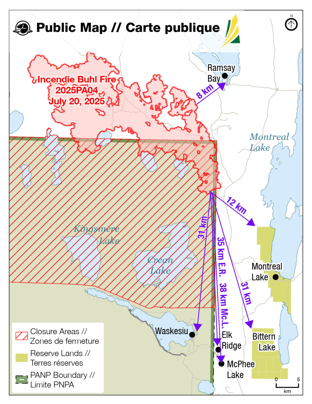
Buhl Fire Update - July 19

Buhl Fire Information Bulletin – July 19, 2025
Location: Saskatchewan
Fire: Parks Canada – 2025PA04-Buhl, SPSA – 25WY-Buhl
Current as of: July 19, 2025 at 12:00 p.m.
Please note that the information provided is current at the time of writing and may be subject to change.
If you see smoke or flames and suspect a wildfire, do not hesitate—call 911 immediately. To report suspicious smoke or wildfires in Prince Albert National Park, call Parks Canada Dispatch at 780 852 3100 or Prince Albert National Park at 306 663 4522.
Your quick action can save lives, protect homes, and help emergency responders contain the fire before it spreads.
SK Wildfire Inquiry Line
Available daily from 8:00 a.m. to 5:00 p.m. Toll-free: 1-855-559-5502
Situation Reports are posted daily and can be found on the Sk Publications Website and on the Prince Albert National Park website.
Visual information is located on the SPSA Interactive Wildfire Map.
For more information regarding wildfire weather and smoke, please visit FireSmoke Canada.
To learn more about highway conditions, including closures, please visit Sk Highway Hotline.
Incident Command Objective
Parks Canada and the Saskatchewan Public Safety Agency are operating under a Unified Command structure, ensuring a coordinated and collaborative approach to managing the incident and aligning operational objectives, resource sharing, and public communication.
Objectives for managing this incident are ensuring public safety, protecting critical infrastructure, and preserving valued natural and cultural resources. Collaboration between Parks Canada and the Saskatchewan Public Safety Agency allows for a coordinated wildfire response and sharing of timely and accurate information. Control and suppression efforts are aimed at limiting the spread of the wildfire perimeter, primarily in the direction of nearby communities and values at risk. Strategies will include maintaining safe and open access along key highways and roads and safeguarding community structures.
Closures and Fire Ban
The Saskatchewan Public Safety Agency has issued a fire ban effective at 8 a.m. on July 10, 2025, due to high fire activity and extreme fire risk. The ban encompasses the area north of the provincial forest boundary, up to the Churchill River.
Parks Canada has also initiated a fire ban including all of Prince Albert National Park and an area closure for the northern area of Prince Albert National Park, from the northern boundary extending south to include, but not limited to, the Kingsmere Wilderness Area, Crean Lake and area, Heart Lakes and area, Wabeno, Wassegam, Tibiska, Nova and Osten areas. For more information on the fire ban and area closure, please see the Important Bulletins page of the Prince Albert National Park website: https://parks.canada.ca/pn-np/sk/princealbert/securite-safety/bulletins
Buhl Fire Summary
The Buhl Fire, first identified on June 29, 2025, was caused by a lightning strike and has burned approximately 45, 667 hectares – 9,575 hectares within park boundaries and 36,092 hectares on provincial Crown land. Current resources assigned to the incident include 109 personnel not including additional SPSA support staff, 9 helicopters, and 11 pieces of heavy equipment.
Provincial Operation Level: Level 3 - Provincial Response/Provincial EOC activated
Fire Distance from Communities: Please note these are approximations and not exact distances. This information is only provided as a reference. Continue to monitor and follow instructions provided through the various emergency channels.
There was no significant growth towards communities on July 18.
Ramsay Bay – 9 km.
Montreal Lake – 12 km
Waskesiu – 31 km.
Bittern Lake – 32 km
Elk Ridge – 35 km.
McPhee Lake – 38 km.
Community Status Update:
Montreal Lake Cree Nation issued an evacuation for priority one and priority two residents on July 13, 2025, due to the dense, persistent wildfire smoke in the community. This order remains in effect. For more information, contact Dean Henderson or Lionel Bird.
Parks Canada issued a pre-evacuation alert for Prince Albert National Park on July 13, 2025. This alert remains in effect. For more information, see Saskalerts.ca
Ramsay Bay, Elk Ridge and McPhee Lake do not currently have any alerts or orders in effect.
While there is no immediate threat to public safety, changes in the weather and fire behaviour could put public safety at risk.
Weather Forecast – July 19
Cloudy skies. Max Temp: 24C, Min RH: 30%, Winds: SE 5-15, gusts up to 30 km/h, Precipitation: Nil. Smoky conditions may lift when a surface inversion breaks around 09:00 CST. Another surface inversion will build by 21:00 CST.
Operations from July 18
· Constructed fire breaks east of Highway 2 toward Montreal Lake Cree Nation as a contingency measure to protect community infrastructure.
· Secured control line south of Bell Lake and east of the MacLennan River with retardant drops to prevent easterly and southerly spread to limit threat to Highway 2.
· Crews did ground suppression on the southerly finger of the Buhl fire, west of the MacLennan River, to prevent easterly or southerly spread to limit threat to Highway 2 and communities south of the fire.
· Conducted controlled ignition operations on northeast of fire to hold the fire to the 916 Road to limit easterly spread to limit threat to the community of Ramsay Bay and Highway 2.
· Maintained value protection previously set up along the 916 Road corridor to protect community infrastructure.
· Widened Rock Lake Road from its junction with the 916, including fuel reduction along the east side of the roadway to limit the community of Ramsay Bay.
Today’s Focus: The following is the current operational plan for fire crews across the incident zone. Due to the dynamic nature of wildfire response, crews and equipment may be reassigned at any time. This information reflects intentions, not guarantees.
Priorities for Operations for July 19
· Monitoring and maintaining value protection units along the 916 Road up to Elaine Lake, with additional supplies including mixed gas and extra pumps being deployed to support these efforts.
· Continue ground suppression on the southerly finger of the Buhl fire west of the MacLennan River to limit easterly or southerly spread.
· Continue controlled ignition operations south of Bell Lake near the 916 Road to create future control lines.
· Float trucks remain staged at Halfway House and will be utilized as needed, particularly in support of ongoing and upcoming ignition operations. Air operations are now being staged near the townsite of Waskesiu to support operations.
· Sprinkler line installation continues along the fire guard north of Bell Lake. Once this setup is complete, float trucks will be deployed to monitor the ignition area from the previous day.
Fire Map: Last Updated – 10:00 hours, July 19, 2025
*Maps will be updated when there are significant changes to the perimeter of the Buhl Wildfire*
Buhl Fire Update - July 18
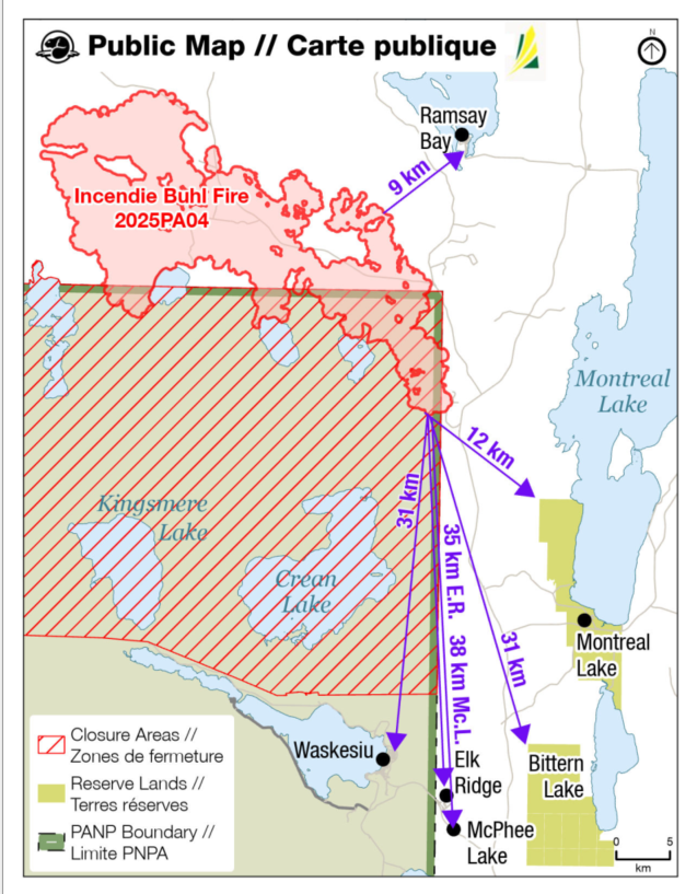
Buhl Fire Information Bulletin – July 18, 2025
Location: Saskatchewan
Fire: Parks Canada – 2025PA04-Buhl, SPSA – 25WY-Buhl
Current as of: July 18, 2025 at 12:00 p.m.
Please note that the information provided is current at the time of writing and may be subject to change.
If you see smoke or flames and suspect a wildfire, do not hesitate—call 911 immediately. To report suspicious smoke or wildfires in Prince Albert National Park, call Parks Canada Dispatch at 780 852 3100 or the Prince Albert National Park at 306 663 4522.
Your quick action can save lives, protect homes, and help emergency responders contain the fire before it spreads.
SK Wildfire Inquiry Line
Available daily from 8:00 a.m. to 5:00 p.m. Toll-free: 1-855-559-5502
Situation Reports are posted daily and can be found on the Sk Publications Website and the Important Bulletins web page on the Prince Albert National Park website.
Visual information is located on the SPSA Interactive Wildfire Map.
For more information regarding wildfire weather and smoke, please visit FireSmoke Canada.
To learn more about highway conditions, including closures, please visit Sk Highway Hotline.
Incident Command Objective
Parks Canada and the Saskatchewan Public Safety Agency are operating under a Unified Command structure, ensuring a coordinated and collaborative approach to managing the incident and aligning operational objectives, resource sharing, and public communication.
Objectives for managing this incident are ensuring public safety, protecting critical infrastructure, and preserving valued natural and cultural resources. Collaboration between Parks Canada and the Saskatchewan Public Safety Agency (SPSA) allows for a coordinated wildfire response and sharing of timely and accurate information. Control and suppression efforts are aimed at limiting the spread of the wildfire perimeter, primarily in the direction of nearby communities and values at risk. Strategies will include maintaining safe and open access along key highways and roads and safeguarding community structures.
Closures and Fire Ban
The Saskatchewan Public Safety Agency (SPSA) has issued a fire ban effective at 8 a.m. on July 10, 2025, due to high fire activity and extreme fire risk. The ban encompasses the area north of the provincial forest boundary, up to the Churchill River.
This fire ban in includes all of Prince Albert National Park and an area closure for the northern area of Prince Albert National Park, from the northern boundary extending south to include, but not limited to, the Kingsmere Wilderness Area, Crean Lake and area, Heart Lakes and area, Wabeno, Wassegam, Tibiska, Nova and Osten areas. For more information on the fire ban and area closure, please see the Important Bulletins page of the Prince Albert National Park website.
Buhl Fire Summary
The Buhl Fire, first identified on June 29, 2025, was caused by a lightning strike and has burned approximately 42,615 hectares – 8,470 hectares within park boundaries and 34,146 hectares on provincial Crown land. Current resources assigned to the incident include 96 personnel, 8 helicopters, and 12 pieces of heavy equipment.
Provincial Operation Level: Level 3 - Provincial Response/Provincial EOC activated
Fire Distance from Communities: Please note these are approximations and not exact distances. This information is only provided as a reference. Continue to monitor and follow instructions provided through the various emergency channels.
There was no significant growth towards communities on July 17.
Ramsay Bay – 9 km.
Montreal Lake – 12 km
Waskesiu – 31 km.
Bittern Lake – 32 km
Elk Ridge – 35 km.
McPhee Lake – 38 km.
Weather Forecast – July 18
Mix of sun and clouds. Max temp 23°C, min RH 25%. Winds E 5-10 km/h Precipitation: Nil. Smoky conditions may lift when a surface inversion breaks around 09:00 CST. Another surface inversion will build by 21:00 CST.
Weather conditions may lead to fire spread today with potential for spotting.
Operations from July 17
- Held the fire along the 916 Road to prevent fire northerly spread and held the fire south of Bell Lake by MacLennan River to prevent easterly or southerly spread to limit threat to Highway 2.
- Established ground suppression and used water tankers to support ground crews by southerly finger of Buhl Fire and used water tankers to support ground crews.
- Completed assessment of critical infrastructure protection needs in the townsite of Waskesiu.
Today’s Focus: The following is the current operational plan for fire crews across the incident zone. Due to the dynamic nature of wildfire response, crews and equipment may be reassigned at any time. This information reflects intentions, not guarantees.
Priorities for Operations for July 18
· Construct fire breaks east of Highway 2 toward Montreal Lake Cree Nation as a contingency measure to protect community infrastructure.
Establish access to southern shore of Mac Lakes to continue ground suppression on southerly finger of fire between the MacLennan River and the Mac Lakes.
Assess controlled ignition options on the northeast of the fire to create a future holding line that will limit easterly spread and limit threat to the community of Ramsay Bay and Highway 2.
· Maintain value protection previously set up along the 916 Road corridor to protect community infrastructure.
· Widening Rock Lake Road from its junction with the 916, including fuel reduction along the east side of the roadway to protect the community of Ramsay Bay.
Attached fire Map: Last Updated – 10:00 hours, July 17, 2025
*Maps will be updated when there are significant changes to the perimeter of the Buhl Wildfire*
Buhl Fire Update - July 17

Buhl Fire Update– July 17, 2025
Location: Saskatchewan
Fire: Parks Canada – 2025PA04-Buhl, SPSA – 25WY-Buhl
Current as of: July 17, 2025 at 2:00 p.m.
Please note that the information provided is current at the time of writing and may be subject to change.
If you see smoke or flames and suspect a wildfire, do not hesitate—call 911 immediately. To report suspicious smoke or wildfires in Prince Albert National Park, call Parks Canada Dispatch at 780 852 3100 or the Prince Albert National Park at 306 663 4522.
Your quick action can save lives, protect homes, and help emergency responders contain the fire before it spreads.
SK Wildfire Inquiry Line
Available daily from 8:00 a.m. to 5:00 p.m. Toll-free: 1-855-559-5502
Situation Reports are posted daily and can be found on the Sk Publications Website.
Visual information is located on the SPSA Interactive Wildfire Map.
For more information regarding wildfire weather and smoke, please visit FireSmoke Canada.
To learn more about highway conditions, including closures, please visit Sk Highway Hotline.
Incident Command Objective
Parks Canada and the Saskatchewan Public Safety Agency are working collaboratively to allow both organizations to have authority and responsibility for this incident while working together effectively without losing their individual authority.
Objectives for managing this incident are ensuring public safety, protecting critical infrastructure, and preserving valued natural and cultural resources. Collaboration between Parks Canada and the Saskatchewan Public Safety Agency (SPSA) allows for a coordinated wildfire response and sharing of timely and accurate information. Control and suppression efforts are aimed at limiting the spread of the wildfire perimeter, primarily in the direction of nearby communities and values at risk. Strategies will include maintaining safe and open access along key highways and roads and safeguarding community structures.
Closures and Fire Ban
The Saskatchewan Public Safety Agency (SPSA) has issued a fire ban effective at 8 a.m. on July 10, 2025, due to high fire activity and extreme fire risk. The ban encompasses the area north of the provincial forest boundary, up to the Churchill River.
This fire ban in includes all of Prince Albert National Park and an area closure for the northern area of Prince Albert National Park, from the northern boundary extending south to include, but not limited to, the Kingsmere Wilderness Area, Crean Lake and area, Heart Lakes and area, Wabeno, Wassegam, Tibiska, Nova and Osten areas.
Buhl Fire Summary
The Buhl Fire, first identified on June 29, 2025, was caused by a lightning strike and has burned approximately 40,958 hectares— 8,113 hectares within park boundaries and 32,845 hectares on provincial Crown land. Current resources assigned to the incident include 95 personnel, 7 helicopters, and 14 pieces of heavy equipment.
Provincial Operation Level: Level 3 - Provincial Response/Provincial EOC activated
Fire Distance from Communities: Please note these are approximations and not exact distances. This information is only provided as a reference. Continue to monitor and follow instructions provided through the various emergency channels.
Elk Ridge – 35 km.
McPhee Lake – 38 km.
Montreal Lake – 12 km.
Ramsey Bay – 9 km.
Waskesiu – 31 km.
Weather Forecast
Outlook for Thursday: The surface ridge will begin to break around 08:30 CST. A broad surface ridge and upper trough will bring mostly cloudy skies with a chance of light rain showers and a risk of thunderstorms. Up to 5mm of rain, winds gusting 70km/h and a risk of dry lightning in thundershowers.
Max temp 23°C, min RH 30%. Winds light and variable – SW in the morning then switching N-NE. Precipitation: trace in any showers.
Outlook for Friday will be partly cloudy south. North and east-central SK: mostly cloudy with showers and risk of thundershowers. Elsewhere: sun/cloud mix.
Operations from July 16
- Parks Canada and SPSA crews, heavy equipment and air tankers collaborated to drop retardant to hold the fire near the MacLennan River and reduce easterly spread to Highway 2.
- Established and reinforced control lines to limit fire spread towards populated areas, including Montreal Lake Cree Nation, Ramsey Bay, the townsite of Waskesiu Lake, Elk Ridge and McPhee Lake.
- Constructed and reinforced control lines as contingency measures in key locations, including near east of Rock Lake Road toward Bear Camp junction, west of Highway 2 near Crean Lake, and east of Highway 2 toward Montreal Lake.
- Suppression and ignition operations along the 916 Road in preparation for potential pre-burn operations using Buckmaster ground ignition equipment.
Today’s Focus: The following is the current operational plan for fire crews across the incident zone. Due to the dynamic nature of wildfire response, crews and equipment may be reassigned at any time. This information reflects intentions, not guarantees.
Priorities for Operations for July 17
- Suppression and ignition tactics along the 916 Road to establish and hold control lines, aiming to prevent wildfire spread northeast toward Ramsey Bay and south toward Prince Albert National Park.
- Building and strengthening control lines using heavy equipment, including south of the 916 Road to Bell Lake, widening Rock Lake Road from its junction with the 916, east of Rock Lake Road to Bear Camp, northeast of Cheeyas Lake, and both north and sorth of the 916 Road. Additional control lines are being strengthen west of Highway 2 near Crean Lake and Wassegam Lake in Prince Albert National Park.
- Protecting critical infrastructure, values and community structures. A structural fire specialist continues to assess protection needs for critical and other infrastructure, including within the townsite of Waskesiu.
- Extinguishing hotspots and assessing dozer guard north of the 916 Road toward Leadley Lake and pump and hose deployment. Float truck operations continue east of Elaine Lake for extinguishment along roadways.
Buhl Fire Update - July 16
BUHL FIRE UPDATE : JULY 16, 2025 – 10 h 15 CST
WASKESIU LAKE, SASKATCHEWAN, July 15, 2025 – There remains one (1) confirmed fire known as the Buhl Fire in Prince Albert National Park. The Buhl fire is estimated to be 37,787 hectares with 6838 hectares within park boundaries. It is currently 31 km from the townsite of Waskesiu and does not pose a threat to the community at this time.
There are 48 personnel, 3 helicopters and heavy equipment responding. Yesterday, fire personnel successfully established access and cleared lines to Crean Lake for future holdings lines. They also continued work on a Cat line by Crean Lake to limit southerly fire spread. Fire personnel will continue to focus on limiting fire spread to the east and south today.
Crews will extinguish hotspots along the MacLennon River to limit fire spread east towards the community of Ramsay Bay. In addition, they will also complete the control line to Crean Lake and directly attack the southern portion of the fire to limit southerly spread.
Weather conditions are expected to lead to fire spread today with potential for spotting. The fire is out of control and has the potential to grow. While there is no immediate threat to public safety or the townsite of Waskesiu, changes in the weather and fire behaviour could put public safety at risk.
It is especially important to report all suspicious smoke or wildfires to Jasper Dispatch at 780 852 6255 or Prince Albert National Park 306 663 4522.
Closures and Fire Ban
There is a fire ban in effect for all of Prince Albert National Park and an area closure for the northern area of Prince Albert National Park, from the northern boundary extending south to include, but not limited to, the Kingsmere Wilderness Area, Crean Lake and area, Heart Lakes and area, Wabeno, Wassegam, Tibiska, Nova and Ostern areas.
Weather Forecast
The temperature today in Prince Albert National Park is forecasted to be up to 24 degrees with no precipitation. Winds will be light but variable and have the potential to change. Conditions will remain warm and windy.
Smoky conditions often accompany wildfires and are expected throughout the region today. The direction and amount of smoke in an area depends on weather and changes in wind direction.
Smoke forecasts and air quality:
Current smoke forecasts
Canada’s Wildfire Smoke Prediction System (FireWork)
Environment Canada Air Quality Health Index
-30-
Contacts:
Daisy Ramsden
Fire Information Officer
306 914 6289
Buhl Fire Update - July 15
WASKESIU LAKE, SASKATCHEWAN, July 15, 2025 – There is currently one (1) confirmed fire known as the Buhl Fire in Prince Albert National Park. The Buhl fire is estimated to be 33,917 hectares with 6262 hectares within park boundaries. It is currently 31 km from the townsite of Waskesiu and does not pose a threat to the community at this time.
There are 29 personnel, 3 helicopters and heavy equipment responding. Fire personnel are focused on limiting southerly fire spread. They have planned Cat lines north and south of MacLennon River as well as one north of Crean Lake. Additional Cat lines are in progress to protect the communities of Ramsay Bay and one is planned for Montreal Lake Cree Nation. They will also conduct bucketing operations near Crean Lake. Crews have set up value protection for backcountry cabins and cultural areas in Prince Albert National Park.
Weather conditions are expected to lead to fire spread today with potential for spotting. The fire is out of control and has the potential to grow. While there is no immediate threat to public safety or the townsite of Waskesiu, changes in the weather and fire behaviour could put public safety at risk.
It is especially important to report all suspicious smoke or wildfires to Jasper Dispatch at 780 852 6255 or Prince Albert National Park 306 663 4522.
Closures and Fire Ban
There is a fire ban in effect for all of Prince Albert National Park and an area closure for the northern area of Prince Albert National Park, from the northern boundary extending south to include, but not limited to, the Kingsmere Wilderness Area, Crean Lake and area, Heart Lakes and area, Wabeno, Wassegam, Tibiska, Nova and Ostern areas.
Weather Forecast
The temperature today in Prince Albert National Park is forecasted to be up to 20 degrees with no precipitation. Winds will be N-NW at 10 km/hr with gusts up to 20 km/hr. Conditions will remain warm and windy.
Smoky conditions often accompany wildfires and are expected throughout the region today. The direction and amount of smoke in an area depends on weather and changes in wind direction.
Smoke forecasts and air quality:
Current smoke forecasts
Canada’s Wildfire Smoke Prediction System (FireWork)
Environment Canada Air Quality Health Index
Buhl Fire Update - July 14
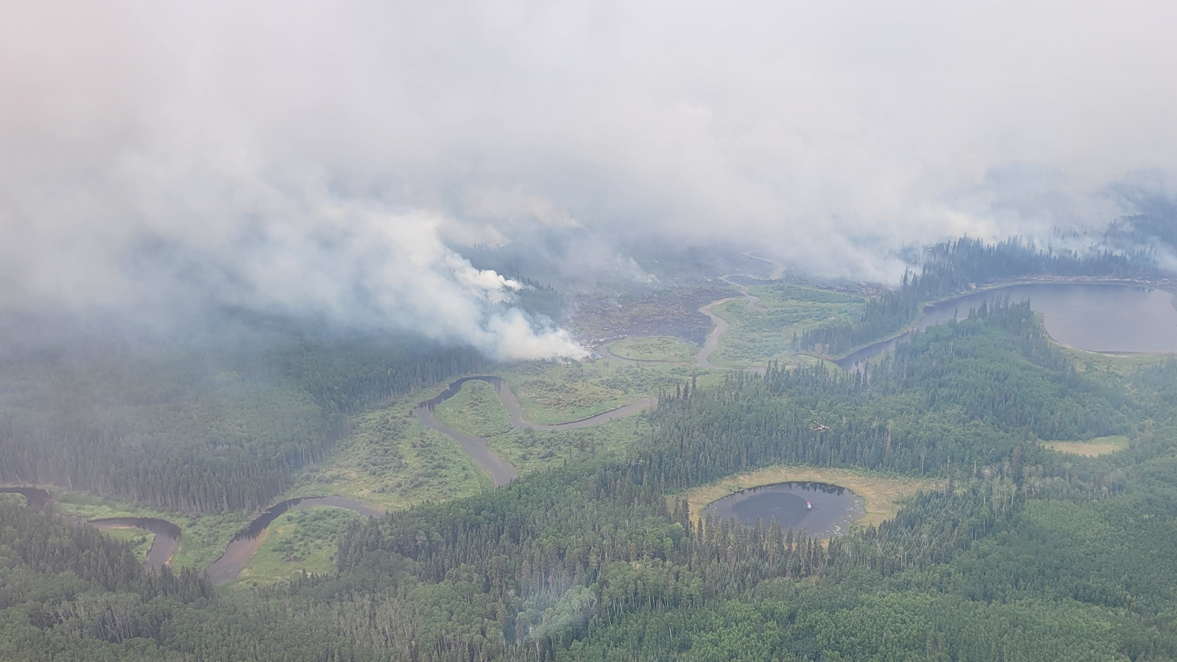
Parks Canada is taking proactive steps to reduce the risk of wildfire and ensure visitor safety.
Wildfire Update: The Buhl Fire was detected on June 30, 2025 north of Prince Albert National Park, and on July 12th spread into the north and northeastern areas of the park. Fire conditions are currently extreme, meaning conditions are favorable for continued fire growth. The fire is currently approximately 35 km from the townsite of Waskesiu. This fire is being managed collaboratively by the Saskatchewan Public Safety Agency (SPSA) and Parks Canada. Fire management specialists are continuing facility protection work in the north end of the park, in addition to two ground fire crews, with more resources incoming.
Area Closure: Effective July 13, the northern area of the park, from the entire north boundary extending south, including and not limited to the Kingsmere Wilderness Area, Crean Lake and area, Heart Lakes and area, Wabeno, Wassegam Tibiska, Nova and Osten areas are closed. See additional information about the area closure.
Pre-evacuation Alert: A pre-evacuation alert for Prince Albert National Park was issued on July 13. Heavy smoke exists in Waskesiu as a result of the wildfire and will remain through the week. Visibility is limited and wildfire smoke can impact health. For residents and visitors, an alert means ‘if you are able to leave, please do so now. The community of Montreal Lake Cree Nation, located outside of Prince Albert National Park, ordered evacuation on June 13, 2025 due to smoke from the wildfires. Highways are expected to be busy.
Fire Ban: A fire ban is also in place for all areas of Prince Albert National Park. See additional information about the fire ban.
Helpful links
Current wildfire and fire ban situation
The province maintains a special wildfire and fire ban information websites:
Saskatchewan
Register with the Province of Saskatchewan before an emergency happens:
- Sign up for Sask-Alerts
- Pre-register on the Saskatchewan Evacuation App
- Date modified :